Walking tours · History · 5 stops
Churchyards and Burying Grounds
A short loop of about a mile and three quarters through the four places where Newburyport buried its dead: the churchyard of St. Paul's, the hilltop burying ground behind the Frog Pond, the town's "New Hill" of 1800, and the garden cemetery of 1842 on the old turnpike. Five stops, a few long legs, and the best epitaphs in town.
- Length
- About 1.8 mi, a loop
- Time
- About 55 min, with the reading
- Start and finish
- St. Paul’s Church, 166 High Street
Before you set off
The oldest graves on this walk are older than Newburyport itself. John J. Currier's History of Newburyport, published in 1906, says the Third Parish of Newbury, the "water side" people who would become Newburyport in 1764, built their meeting house in Market Square in 1725 and four years later laid out a burying ground on the hill behind the Frog Pond; the Church of England families raised St. Paul's at the head of Market Street in 1738 and were burying in its yard by 1742. Currier adds that when the new town was incorporated both grounds lay near its geographical centre, so that bearers could carry a coffin from the house to the grave on their shoulders; the town did not buy its first two hearses until 1813.
Each of the four grounds belongs to a different idea of what a burying place should be: a churchyard beside the church, a parish hill with slate stones and carved angels, a town lot bought by vote of town meeting, and finally, in 1842, a private association's "well-arranged and attractive cemetery" of winding avenues under old oaks, which Currier's "Ould Newbury" of 1896 calls a "silent city of the dead." Mrs. E. Vale Smith's History of Newburyport of 1854, Sarah Anna Emery's Reminiscences of a Nonagenarian of 1879 and the two volumes of Currier's History will do most of the talking; the stones themselves do the rest.
Numbers follow the walk. The line is the route along the streets, back to where you started.
Read it aloud as you go: each stop begins with where to walk and where to stand, then what the old histories say about the place. The sources are named as you read and listed in full at the end.
StartThe loop begins at St. Paul's Church, the granite church on the corner of High Street and Market Street, at 166 High Street; there is on-street parking along High Street and in the streets below it. Stand on the High Street sidewalk in front of the church, with the tower above you and Market Street running downhill to your left. look: Granite walls and a square tower in a Colonial Revival dress; the state inventory form says this is the third church on the spot, built in 1922 and 1923.
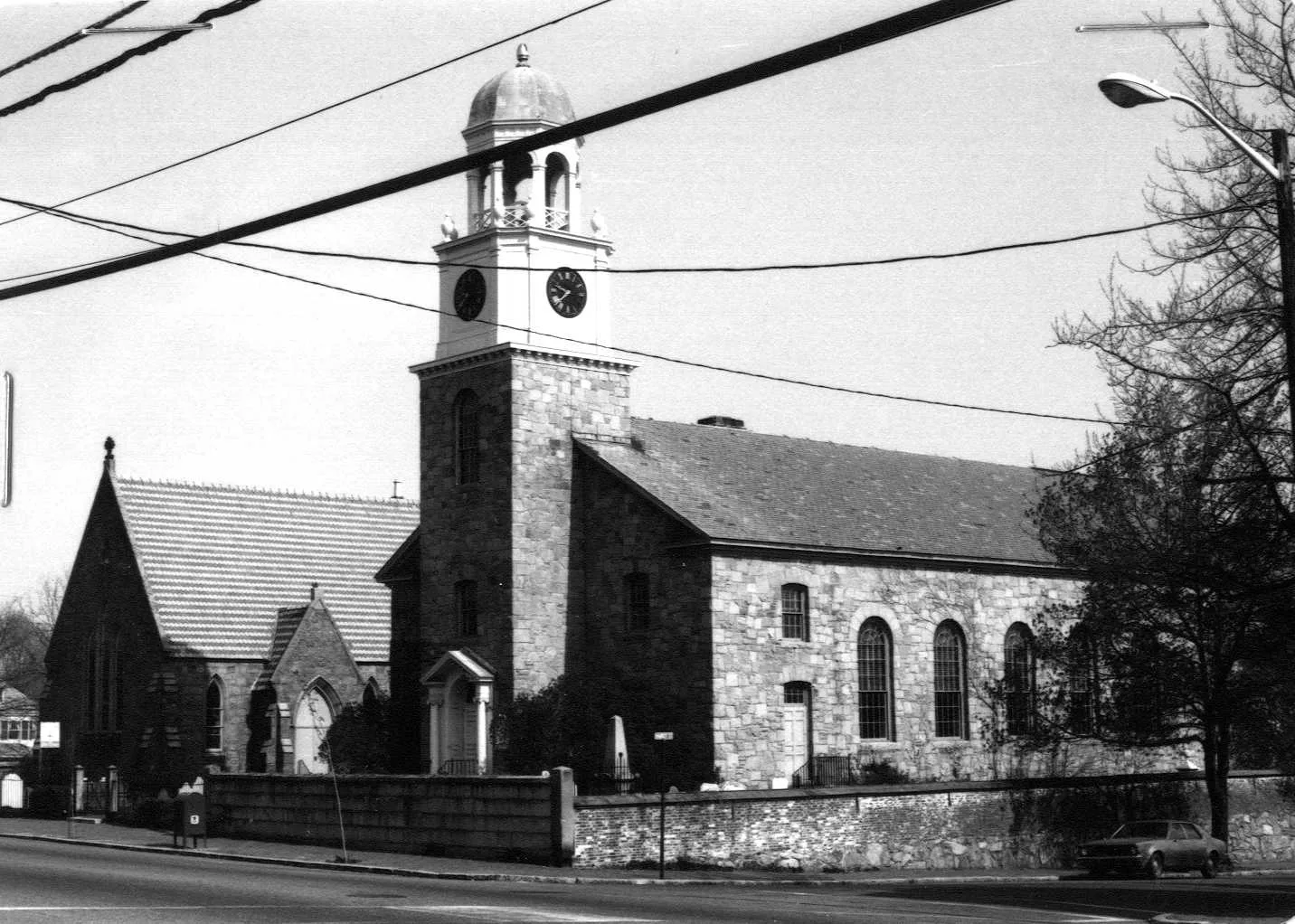
Stop 1 · c. 1922
166 High Street
St. Paul's Episcopal Church
Photo: Massachusetts Historical Commission, MACRIS inventory
The parish is older than the town. Sarah Anna Emery's Reminiscences of 1879 say that as early as 1725 "the church people dwelling at the water side" wanted a church of their own, and that in 1738, after the Reverend Matthias Plant of Queen Anne's Chapel and the merchant Joseph Atkins had each offered fifty pounds, "the foundation of one was laid at the head of Queen, now Market street." Currier's "Ould Newbury" prints Atkins's deed of February 3, 1741, giving the land on "Queen Street, or Ordway's Lane," with the building on it, for worship forever "according to ye Rubrick of ye Common Prayer Book used by the Church of England." Emery remembered it: "I have a recollection of the old building, which was small and painted light yellow."
The man the church is remembered for is Edward Bass. Mrs. Smith's History of 1854 says he entered Harvard at thirteen, was chosen Plant's assistant in 1751, went to England for ordination, and became rector on Plant's death in 1753. Currier prints his letter of July 16, 1776, agreeing to drop the prayers for the king "during the present state of our political affairs," and says he stayed at his post all through the war. He was consecrated the first Episcopal bishop of Massachusetts in 1797, and when the church was rebuilt in 1800 and 1801 a carved wooden mitre went up above the belfry, Currier says, "to indicate that the new edifice was a cathedral." Timothy Dexter gave a hundred pounds toward it; a painted notice in the parish house records "MR. TIMOTHY DEXTER Generously gave the sum of $333.33 Towards the Finishing and Ornamenting of this church." The present granite church is the third on the site; its bell was cast in 1899 in memory of the Reverend James Morss, rector from 1803 to 1842.
Sources: MACRIS inventory form · Emery, Reminiscences of a Nonagenarian (1879), p. 198 · Currier, “Ould Newbury” (1896), ch. "St. Paul's Church" · Smith, History of Newburyport (1854), pp. 301, 371 · Currier, History of Newburyport, vol. 1 (1906), pp. 257–264
Walk · 90 yardsWalk along High Street to the corner, about 35 yards, and turn left down Market Street. The churchyard is on your left, behind and beside the church, running down to Summer Street; go in by the gate about 50 yards down Market Street and stand by the two tombs to the left of the little stone chapel. look: The stone chapel: Currier's 1906 History says it was built in 1862 by the rector, the Reverend William Horton, in memory of his daughter Anna M. Horton, who died in 1857, and consecrated on May 27, 1863.
Stop 2 · 1742
St. Paul’s Churchyard
This is the yard where the Church of England families buried their dead, and Currier's "Ould Newbury" of 1896 has the first entry from the rector's own book: "Elizabeth, Dater of Ambrose Davis & Margaret, was ye first corpse interred in ye new church yard by ye water side July 17, 1742, aged 17 months." The oldest stone still standing, Currier says, is Sarah Atkins's, two days later; the oldest person buried here was Joseph Atkins, the merchant who gave the land, dead on January 21, 1773, at ninety-nine by Currier's count; and in 1896 he counted two hundred and eighty inscriptions. His roll of the "worthy and distinguished" runs from Michael Dalton, Anthony Gwynn and Patrick Tracy through Bishop Bass and Dr. Morss to Dudley Atkins Tyng and Tristram Dalton. Bass died on September 10, 1803, in his seventy-sixth year, and was buried here on the thirteenth.
Dalton's stone is the one Currier put in the foreground of his photograph of the yard. Caleb Cushing's history of 1826 has him born in Newbury in 1738, a merchant with his father, then representative, speaker of the House, state senator "and lastly member of the Senate of the United States"; when his term ended he sold his Essex estate, moved to Washington and lost his fortune in speculation. Mrs. Smith says he died in Boston in June 1817, aged seventy-nine, "and his remains were brought to his native town for burial," to the yard of the church where he had been a warden. The site's own list of graves adds names the histories pass over: Flora Marston, who died in 1788 at nineteen, the only known burial here of a person of African descent, near the Summer Street wall; the physician John Brickett; and Captain Wyatt St. Barbe.
Sources: Currier, “Ould Newbury” (1896), ch. "St. Paul's Church" · Currier, History of Newburyport, vol. 1 (1906), pp. 215, 264, 341 · Cushing, History and Present State of Newburyport (1826) · Smith, History of Newburyport (1854), p. 345 · oldnbpt.com research
Walk · 310 yardsGo back up Market Street to High Street and turn left. After about 35 yards bear left off High Street into Auburn Street, which drops away downhill, and follow it about 90 yards to Greenleaf Street. Turn left onto Greenleaf Street; the Frog Pond and Bartlet Mall open out on your left and the burying ground climbs on your right. Walk about 135 yards along Greenleaf Street to the gate on your right and go in; the whole leg is about 300 yards. look: Slate stones with winged heads on the crest; the long row of low stones in the hollow on the far, northwesterly side are the French refugees.
Stop 3 · 1729
Old Hill Burying Ground
Currier's "Ould Newbury" says the Third Parish voted in the spring of 1730 to fence, for burials, "the lot of land in the rear of Frog Pond, then known as Snelling's hill," after a physician of 1650. The 1906 History adds that the town's powder house of 1754 stood beside the ground, and that in 1790 the enclosure was enlarged down to Pond Street and Auburn Street.
The ministers are on the top: Currier puts the Reverend John Lowell, the parish's first minister, on the summit, with Murray of the Old South and Milton of Prospect Street a few rods off, and his list runs from Colonel Richard Kent, who died in 1740, to Mrs. Mary Toppan, dead at a hundred and five. The epitaphs are the thing. Captain William Starkey's of 1766 begins, "Tho Neptunes waves & Boreas Blasts Has toss'd me to and Fro. In Spite of both, by God's Decree, I'm Anchored here below," and Mrs. Mary McHard's slab near Pond and Greenleaf Streets records that she died in 1780 "by swallowing a pea at her own table." On the northwesterly side lies Timothy Dexter. William C. Todd's inquiry of 1886 says Dexter asked to be laid in the tomb he had built in his garden, "but the board of health interfered, and he rests with his follies in the cemetery close to the beautiful mall." In the hollow below are the French refugees of the 1790s, among them Marie Félicité Nadau, whose story Hannah F. Gould told in "The Grave beneath the Thorn Tree." Near Pond and Auburn Streets is the marble for seven of the crew of the brig Pocahontas, lost on Plum Island in December 1839: "In foreign lands their humble grave adorned By strangers honored and by strangers mourned." Mrs. Smith saw a stone here in 1854 put up by Tristram Dalton "To Pompey, a faithful servant"; the site's list names Fortune, of the same household, who died in 1804.
Sources: Currier, “Ould Newbury” (1896), ch. "Old Hill Burying Ground" · Currier, History of Newburyport, vol. 1 (1906), pp. 214–215, 217, 255 · Todd, Timothy Dexter (1886) · Smith, History of Newburyport (1854), p. 345 · Currier, History of Newburyport, vol. 2 (1909), pp. 18–19 · oldnbpt.com research
Walk · 320 yardsCome out by the Greenleaf Street gate, turn left, and walk back up Greenleaf Street about 130 yards to Auburn Street. Turn left onto Auburn Street and follow it, with the lower slope of Old Hill on your left, about 180 yards to the Highland Cemetery sign on your left, opposite Boylston Street. Go in at the sign.
Stop 4 · 1800
Highland Cemetery
The town bought this ground when the old hill filled up. Currier's "Ould Newbury" says a committee of William Bartlett, Moses Brown, Abraham Wheelwright, Stephen Cross and Moses Hoyt was named in 1799 to find "a suitable and convenient piece of land for a burying ground," and that in August 1800 the town bought five acres of William Coffin Little, an Amesbury silversmith, and Francis Little, mariner, for nine hundred and seventy dollars, on the lane "formerly called West India Lane, now called Hill street." The deed reserved five rods at the corner "in which there are now several graves," for the Littles had been burying here long before the town came; the oldest stone, Currier says, is Sarah Little's, which he reads as 1735. The 1906 History says the selectmen leased "about four acres of the land lately purchased by the Town for a burying ground" to Moses Hoyt for three years to plough and lay down to grass, and that the place was called the New Hill burying ground. In 1848 the town bought the Davenport pasture next door and voted "to lay out the Burial Grounds in Lots and Tiers, the lots to be sold at a reasonable price"; by Currier's day the old New Hill was a corner of Highland Cemetery.
Currier's list of stones is a roll of the merchants and ministers of the town's best years: Stephen Hooper; Joseph Marquand; Captain Offin Boardman; James Prince, "Collector of this District"; Margaret Atwood, who left the income of her estate to the poor of the town; the poet Hannah Flagg Gould, beside her father Benjamin, "an officer of the Revolution"; the pastors Samuel Spring and John Giles; and Caleb Cushing, the city's first mayor by Hurd's roll, who died in 1879. The site's own list adds people the histories leave out, among them the Pearson family of ship's-biscuit bakers, whose bake-houses on Centre Street Emery remembered, and the Civil War nurse Sarah E. Smith.
Sources: Currier, “Ould Newbury” (1896), ch. "New Hill Burying Ground" · Currier, History of Newburyport, vol. 1 (1906), pp. 216–218 · Hurd, History of Essex County, vol. 2 (1888) · Emery, Reminiscences of a Nonagenarian (1879), p. 228 · MACRIS inventory form · oldnbpt.com research
Walk · 0.7 miThis is the long leg, about seven tenths of a mile. Come back out to Auburn Street, turn left, and continue downhill about 65 yards to where the street ends; carry straight on along the footpath for about 75 yards, which brings you out onto Pond Street. Follow Pond Street about 185 yards and carry straight on into Greenleaf Street, which bends to the right and runs on for about 320 yards, crossing the side streets, until it meets State Street. Turn right onto State Street, away from downtown, and after about 20 yards turn left into Brown Street. In about 30 yards the street passes through the granite gateway and becomes the cemetery drive; follow the drive up the hill, past the chapel, for about 500 yards. The whole leg is about three quarters of a mile. look: The granite gateway you came through: Currier says it was the gift of John S. Tappan of New York in July 1864.
Stop 5 · 1842
Oak Hill Cemetery
Currier's "Ould Newbury" says that in January 1842 the Reverend Thomas B. Fox of the First Religious Society and a few friends formed an association "for the purpose of providing and maintaining a cemetery of suitable proportions, to be tastefully arranged and properly cared for," bought the Moses Brown heirs' land on the turnpike, now State Street, at two hundred dollars an acre. The ground was consecrated on Thursday afternoon, July 21, 1842, with hymns written by Hannah F. Gould and George Lunt; "The exercises, held under the shade of stately and venerable oak trees still standing on the hillside, were simple and impressive." By 1896 Currier counted more than thirty-six hundred burials on twenty-five acres. The way in from State Street was cut in 1855, and John T. Brown's will paid for the memorial chapel the 1906 History expected near the main entrance. From the summit, Currier says, "the eastern outlook reveals, half hidden through the trees, glimpses of the river and the sea beyond."
His roll of the monuments is the city's nineteenth century: John Bromfield, who left the fund for the town's shade trees; William Bartlet, the merchant who endowed Andover; James Parton the biographer; and Eben F. Stone, colonel of the Forty-eighth and three times congressman. William Wheelwright is here too, born in 1798; "Ould Newbury" follows him from cabin boy to Valparaiso, where he founded the Pacific Steam Navigation Company in 1838 and built the first South American railroad, and brings him home from London for burial in 1873. Currier's History of Newbury of 1902 says Donald McKay, who built ships here before East Boston, was buried here in 1880. The site's own list points out Captain Francis Todd, the shipowner whose vessel's carrying of slaves brought William Lloyd Garrison a libel conviction and forty-nine days in a Baltimore jail, as the second volume of Currier's History tells it, and Hiram P. Macintosh, the photographer whose negatives Currier used for "Ould Newbury."
Sources: Currier, “Ould Newbury” (1896), ch. "Oak Hill Cemetery" · Currier, History of Newburyport, vol. 1 (1906), pp. 218–219 · Currier, History of Newburyport, vol. 2 (1909), p. 317 · Currier, History of Newbury (1902), p. 489 · oldnbpt.com research
Back to the start · 0.7 miGo back down the drive the way you came, about 500 yards, out through the Tappan gateway and along Brown Street to State Street. Turn right onto State Street toward downtown, and after about 20 yards turn left into Greenleaf Street. Follow Greenleaf Street the whole way, a little over a quarter of a mile, past the lower end of Old Hill and along the Frog Pond, to Auburn Street; turn right onto Auburn Street and climb about 90 yards to High Street, then carry on along High Street about 70 yards to St. Paul's. The return is about seven tenths of a mile.
The walk back along Greenleaf Street passes the oldest of the four grounds last. Currier's "Ould Newbury" warned in 1896 that on Old Hill "Many of the tombstones and marble slabs that mark their graves show signs of age, and need to be carefully repaired and relettered"; a century on, the stones you read today are the ones that survived.
Sources for this walk
The script paraphrases and quotes these works, all of them out of copyright, and names each one as it goes. Page numbers are from the editions linked here. Where the script says “our research for this site,” the facts are from the building page it links to.
- John J. Currier, History of Newburyport, Mass., 1764–1905, vol. 1 (Newburyport: the author, 1906). archive.org/details/historyofnewbury01curr
- John J. Currier, History of Newburyport, Mass., 1764–1905, vol. 2 (Newburyport: the author, 1909). archive.org/details/historyofnewbury04curr
- John J. Currier, “Ould Newbury”: Historical and Biographical Sketches (Boston: Damrell & Upham, 1896). archive.org/details/ouldnewburyhisto00curr
- John J. Currier, History of Newbury, Mass., 1635–1902 (Boston: Damrell & Upham, 1902). archive.org/details/historyofnewbury1902curr
- E. Vale Smith, History of Newburyport; from the Earliest Settlement of the Country to the Present Time (Newburyport, 1854). archive.org/details/historyofnewbury00blake
- Sarah Anna Emery, Reminiscences of a Nonagenarian (Newburyport: William H. Huse, 1879). archive.org/details/reminiscencesofn00emer
- Caleb Cushing, The History and Present State of the Town of Newburyport (Newburyport: E. W. Allen, 1826). archive.org/details/historypresentst00cush
- William C. Todd, Timothy Dexter, Known as “Lord Timothy Dexter,” of Newburyport, Mass.: An Inquiry into His Life and True Character (Boston, 1886). archive.org/details/timothydexterkno00todd
- D. Hamilton Hurd, comp., History of Essex County, Massachusetts, vol. 2 (Philadelphia: J. W. Lewis & Co., 1888). archive.org/details/historyofessexco02hurd
- Massachusetts Historical Commission, Massachusetts Cultural Resource Information System (MACRIS), Newburyport inventory forms. mhc-macris.net
- Biff Bouse, oldnbpt.com building pages (own research from deeds, Sanborn maps and newspapers). oldnbpt.com
More walks: State Street and Market Square · Green Street, Brown Square and Pleasant Street · High Street: Down Along and the Ridge · Federal, Spring and Middle Streets · The Water Street Waterfront · Joppa: The Oldest Houses · Joppa: The Fishing Village · Along the River: The North End Shipyards · The Rail Trail: Mills, Ropewalks and Old Hill · Newburyport in the Civil War