Walking tours · Waterfront · 19 stops
The Water Street Waterfront
A short, level loop from the old Market House down Water Street and back: the Custom House, the sites of the wharves where the molasses, the hemp and the coal came in, the two range lights that steered ships up the harbor, the ground where a Continental frigate was built, and the lanes behind. About a mile; nothing steeper than Elbow Alley.
- Length
- About 1.1 mi, a loop
- Time
- About 65 min, with the reading
- Start and finish
- The Firehouse, Market Square
Before you set off
This is the oldest commercial ground in Newburyport. Mrs. E. Vale Smith's History of Newburyport, published in 1854, says the first hint of a wharf or dock on the site of the town is a grant of 1655 to Captain Paul White of half an acre near where the Market House now stands, on condition that he build a dock and warehouse there, and Sarah Anna Emery, who was born in 1787 and wrote her Reminiscences of a Nonagenarian at ninety, puts the first wharf at the “water side” in 1656, near the same spot, with a dock, a warehouse and a still-house. John J. Currier's History of Newburyport, published in 1906, says the strip of bank between the road and the river was divided among the proprietors of Newbury in 1715, with ten landing places kept back for loading hay and lumber, and that the way along the river side from Market Square down to Marlborough Street was laid out by the Newbury selectmen in 1739 and 1740, from Pierce's farm up to Ordway's lane, having been used as a highway long before that. It was still called Merrimack Street when the new town laid it out again in 1771.
Two things shaped what you see. The great fire of May 31, 1811, Currier says, began in a stable on Inn Street and burned until two in the morning, “burning nearly two hundred and fifty shops and dwelling houses, between State and Fair streets, and Middle street and Merrimack river.” His “Ould Newbury” of 1896 prints the contemporary account: the whole of Centre Street laid in ashes, “the whole range of buildings in Merchant's row on the Ferry wharf, also all the stores on the several wharves between the market and Marquand's wharf.” So almost everything here between State Street and Fair Street is later than 1811. And the state's historic inventory form for the Custom House says the slip and wharves beside it were filled between 1869 and 1872 for the city railroad line, which is why the water is now so far from a street called Water Street.
Numbers follow the walk. The line is the route along the streets, back to where you started.
Read it aloud as you go: each stop begins with where to walk and where to stand, then what the old histories say about the place. The sources are named as you read and listed in full at the end.
StartThe loop begins in Market Square, at the foot of State Street. Stand in the square in front of the Firehouse, the brick building that closes the river end of the square; there is parking on the waterfront lots behind it. The walk goes down Water Street with the river on your left and comes back the same way.
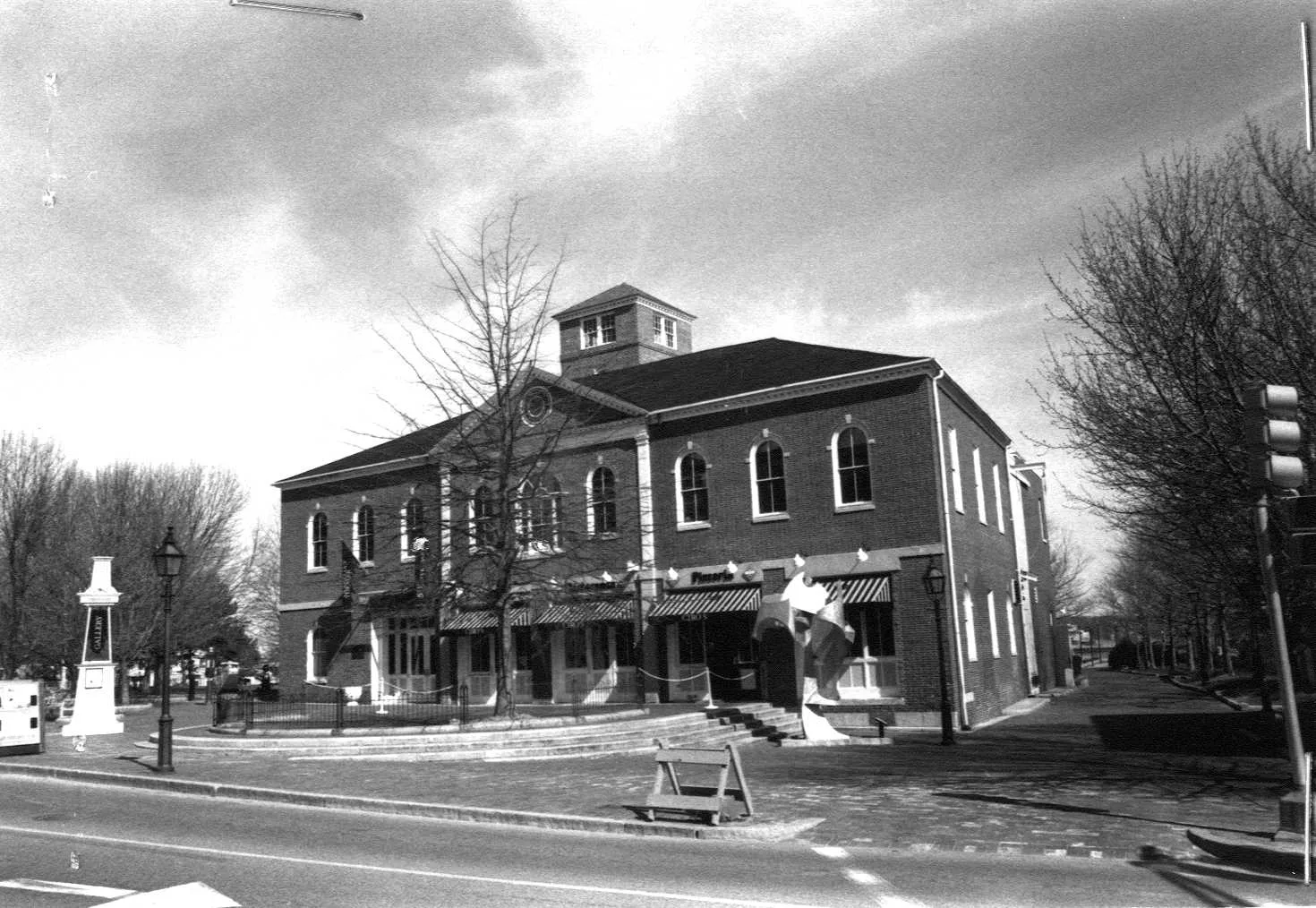
Stop 1 · c. 1825
1–3 Market Square
Old Market House (the Firehouse)
Photo: Massachusetts Historical Commission, MACRIS inventory
The Firehouse is the old Market House. Emery remembered what was here before it: “On the site of the present Market house was a row of low, open butcher's shambles,” kept by David Tenney and by the firm of Colman and Emery, with butchers' carts from the country towns drawn up in the square two or three times a week. Currier's History of 1906 says the land had been laid out as a town way and landing in 1771, when it was still known as the middle shipyard, and that Timothy Dexter offered in 1795 to put up a handsome brick market house on it at his own expense; the town, Currier says in his second volume, was unwilling to recognize him as a public benefactor and declined with thanks; Mrs. Smith's History of 1854 says the only objectionable condition was that it be called Dexter Hall. The town finally voted on August 5, 1822, as Currier prints it, “to build a Market house of brick, one story high, on the site where the shambles lately stood,” then changed its mind and built two stories; the upper floor, he says, was a chair factory for some years, and in 1825 the town agreed to finish it provided St. Mark's Lodge took a ten-year lease for Masonic purposes. “In 1822 the shambles gave place to the present brick market house,” is how Emery puts it; the state's inventory form dates the building about 1825. Emery's best story belongs to its steps: the butcher James Carey shouted across the square at “Rhymer” Toppan that he bought his meat and never would pay, and Toppan answered on the instant, in rhyme, that if that were true he would always buy his meat of Carey.
Sources: Emery, Reminiscences of a Nonagenarian (1879), p. 228 · Currier, History of Newburyport, vol. 1 (1906), pp. 135, 139–141 · Currier, History of Newburyport, vol. 2 (1909), p. 420 · Currier, “Ould Newbury” (1896), pp. 623–625 · Smith, History of Newburyport (1854), p. 175 · MACRIS inventory form
Walk · 80 yardsWalk along the square toward Water Street, about 65 yards, turn left onto Water Street and at once bear left again into Ferry Wharf, the short lane that drops down toward the water behind the Firehouse. Stop after a few steps, where you can see the river.
Stop 2 · Lost
Central Wharf
The water behind the Market House was Central Wharf. Currier's History of 1906 says the Franklin House, a hotel near Market Square at the head of Central Wharf, had probably existed under another name for more than a century, and names the men who kept it in 1849, 1856 and 1860. His second volume, published in 1909, has the river steamers leaving from here: the side-wheel steamer Lawrence, finished in June 1846 for the Newburyport, Boston and Haverhill Steam Boat Company, left Central Wharf at one o'clock each afternoon for Haverhill and came back the next day, stopping at the landings on the way. Our own research for this site remembers the wharf for a bigger launch day: crowds stood here to watch the Union gunboat Marblehead go into the river. Currier records the ship, built in 1862 by George W. Jackman Jr., the shipbuilder who was the city's wartime mayor, 529 tons, for the United States government; his list puts her between the bark Nabob and the steamer Ascutney in Jackman's yard up the river. Emery says the first wharf on the whole waterfront, Paul White's of 1656, was near the present Market House, and that in 1678 Richard Dole built a wharf and dock near “Watts his cellar,” also in what is now Market Square: so the ground under your feet has been a wharf for longer than there has been a Newburyport.
Sources: Currier, History of Newburyport, vol. 1 (1906), pp. 393, 457, 466 · Currier, History of Newburyport, vol. 2 (1909), p. 71 · Emery, Reminiscences of a Nonagenarian (1879), p. 226 · oldnbpt.com research
Walk · 80 yardsGo back up the lane to Water Street and turn left. Walk about 75 yards, keeping the river on your left, to the foot of State Street, which comes down from your right. The river side here was Ferry Wharf.
Stop 3 · Lost
Ferry Wharf
This is where the town crossed the river. Currier's History of 1906 says that in 1688 the governor and council gave Captain John March leave to keep a ferry from Warehouse Point to Ring's Island in Salisbury, and that the Portsmouth Flying Stage Coach, six horses and six passengers inside, came over the ferry at the foot of Fish Street, now State Street, once a week on its way to Boston. After the bridge to Salisbury opened in 1827, Currier says, only a few foot passengers kept using it; Mrs. Smith, walking past in 1854, could still point to “the primitive ferry-way established by Andros, where now, as then, the Merrimac may be crossed in the style of our ancestors,” rowed over at a nominal price. The wharf that grew up here was the merchants' quarter. Emery remembered John Wood's warehouse at the head of Ferry Wharf and a row of groceries below it, one of them William Bayley's. Bayley and Jones's History of the Marine Society, published in 1906, says Captain Le Craw and other shipmasters “spent their leisure hours around the stove in Davenport's store at the head of Ferry wharf,” and Hurd's History of Essex County of 1888 says Anthony Davenport, son of the man who opened the Wolfe Tavern, went into business at the head of this wharf and took his son John into partnership. The 1811 fire took the whole of Merchant's Row on the wharf. One trade survived it: Currier says Ambrose Davis leased a brick building on the wharf at the foot of Fish Street in 1773 and made sails there; it was only partly burned in 1811, and in 1906 was still a sail loft, kept by his descendant Benjamin G. Davis. Our own research for this site adds riggers and a flag supplier to the sail lofts here in the 1800s.
Sources: Currier, History of Newburyport, vol. 1 (1906), pp. 29, 177, 367–368 · Smith, History of Newburyport (1854), p. 270 · Emery, Reminiscences of a Nonagenarian (1879), p. 232 · Bayley and Jones, History of the Marine Society (1906), p. 383 · Hurd, History of Essex County, vol. 2 (1888) · Currier, “Ould Newbury” (1896), p. 645 · oldnbpt.com research
Walk · a few stepsA few steps on, about 40 yards, the granite building on the river side, on your left, is the Custom House, 25 Water Street. Stand across the street from its columned door. look: The two Doric columns of the porch are single blocks of granite, twenty-eight inches across at the base; look up for the iron railings between the four chimneys, which fence a lookout on the roof.
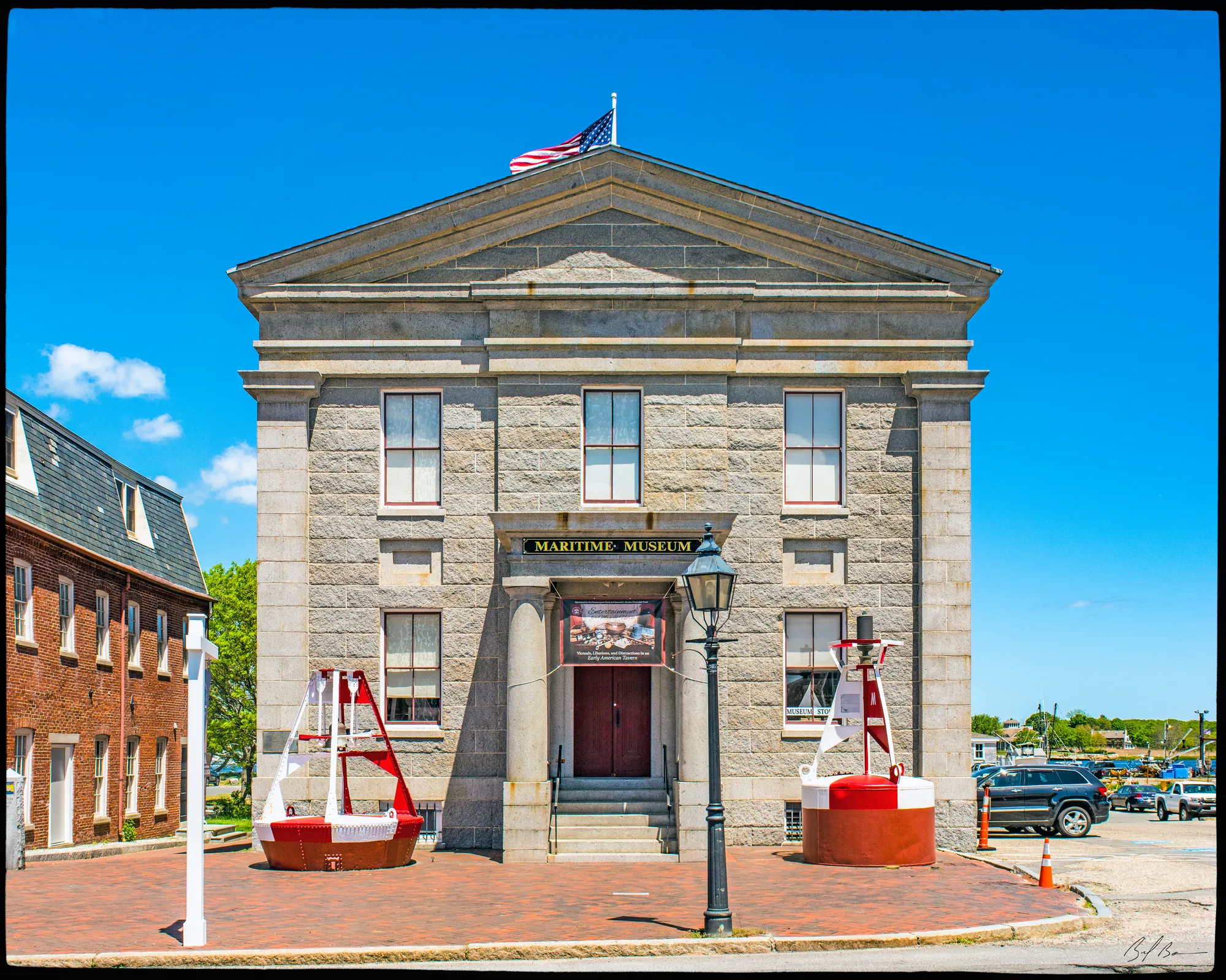
Currier's History of 1906 says the United States bought this land on Water Street near the foot of State Street in 1833 from William Hervey, John Orne, Mary Harrod and others, laid the corner stone on October 24, 1834, and finished the building in 1835 under the supervision of the architect Robert Mills, with William Palmer and Daniel Hazelton as master builders; he prints the list of officers in the corner stone, Samuel Phillips, collector, at the head. The state's inventory form says Mills, who went on to the Treasury Building and the Washington Monument, designed four custom houses at once, and that this one is rough Rockport granite with dressed trim, fireproof inside with groin vaults, a hanging granite stair and marble floors. Mrs. Smith, in 1854, called it “a substantial granite building, which contains not one square foot of wood-work from the cellar to the cupola.”
Before this the customs were in rented rooms: Emery says the custom house of her girlhood was in the Phoenix Building on State Street, Ralph Cross collector, and Mrs. Smith lists the custom house and all its records among the losses of the 1811 fire. Emery also says William Atkins built a handsome house near where the Custom House now stands, with Dutch tiles on the fireplaces; it was the Harrod house when it burned in 1811, and a Mary Harrod was among those who sold the lot in 1833. The inventory form says the building had its own slip until the wharves were filled for the railroad between 1869 and 1872, that receipts peaked in 1875 and 1876 at more than a hundred thousand dollars a year, mostly on sugar and molasses, and that collection ended in 1910. The building was sold in 1913, stored hay, made shoe heels and held a junkyard before the Redevelopment Authority took it in 1968 and restored it; the Custom House Maritime Museum opened on June 28, 1975.
Sources: Currier, History of Newburyport, vol. 1 (1906), pp. 676–677 · MACRIS inventory form · Smith, History of Newburyport (1854), pp. 185, 270 · Emery, Reminiscences of a Nonagenarian (1879), p. 229
Walk · 50 yardsContinue down Water Street about 55 yards. The brick building on the river side, on your left, just past the Custom House, is the old coal company office.
Stop 5 · 1890
Atkinson Coal Company building
The histories have nothing on this one, so it is our own research for this site that identifies it: a brick coal and lumber office of 1890 on the river side of Water Street. It belongs to the last chapter of the port. The state's inventory form for the Custom House next door says that after the Bayley molasses firm closed in 1877 the duties collected here came mainly from imports of soft coal, with an occasional cargo of molasses or tea. The coal came in by schooner and went out by cart from yards along this bank.
Sources: oldnbpt.com research · MACRIS inventory form
Walk · a few stepsCarry on about 50 yards to the foot of Pike Street, which comes up from your right. The comb shop stood here, near the foot of the street.
Stop 6 · Lost
Noyes comb shop
Horn combs were a Newbury trade before they were a Newburyport one. Currier's History of 1906 says Enoch Noyes was making horn buttons and combs in Newbury in 1759, and in 1778 took on William Cleland, a deserter from Burgoyne's army and a comb maker by profession, which Currier calls the beginning of the business in Newbury and elsewhere; by 1831 there were three comb shops in Newburyport and twenty in West Newbury. The Noyes who worked here was a later one. Currier says William Noyes Jr. and his son William Herbert Noyes began making combs in Prince Place in 1871, and that after the firm of Noyes and Vine broke up in 1873 William Herbert Noyes leased a shop on Water Street near the Custom House, “and afterward a large building near the foot of Pike street, which he occupied until 1879,” when he and his brother Davis F. Noyes built a bigger factory on Chestnut Street. By 1906, Currier says, the W. H. Noyes and Brother Company, incorporated in 1899, was the only comb maker left in Newbury, West Newbury or Newburyport. Our research for this site places one of the family's shops here at the foot of Pike Street before the move.
Sources: Currier, History of Newburyport, vol. 1 (1906), pp. 178–180 · oldnbpt.com research
Walk · 100 yardsWalk on about 100 yards to the foot of Fair Street, on your right. The river side here was Cushing's Wharf.
Stop 7 · Lost
Cushing Wharf
This was the wharf of the biggest shipowners the town ever had. Currier's second volume, of 1909, says Captain John Newmarch Cushing was born in Salisbury in 1779, moved to Newburyport in 1802 with his wife and a son of two, Caleb, and in 1806 was part owner and master of the ship Hesper. Hurd's History of Essex County of 1888 says the Hesper was captured on a passage from Russia with hemp and iron, and calls her master a man “who later in life was himself the first merchant and the largest ship-owner in town.” He left the sea in 1815, Currier says, and for the next twenty-five or thirty years was principal owner of a fleet trading to Russia, Holland and the north of Europe; Emery says he and Nicholas Johnson and Henry Johnson moved their freighting business from the Johnson wharf to “the Cushing wharf, which is still owned in the family.” Mrs. Smith says the fire of 1811 stopped on Water Street at Cushing's Wharf. He died on January 5, 1849. His sons John N. and William carried on, importing salt and hemp; Currier says the younger John was managing owner of a large number of Merrimack-built ships from 1851 to 1891, and William was mayor in 1856, 1857 and 1858. Hurd's list of their ships runs from the brig Hesper of 1851 to the Mary L. Cushing of 1883, which Currier's History of 1906 calls the last square-rigged vessel built in Massachusetts, and Bayley and Jones print her captain's memory of her: “She was very beautiful, as many can testify who went on board of her before she went to sea, while she lay at Cushing wharf.” Our research for this site says the firm rigged and fitted out its ships here.
Sources: Currier, History of Newburyport, vol. 2 (1909), pp. 253–254 · Hurd, History of Essex County, vol. 2 (1888) · Emery, Reminiscences of a Nonagenarian (1879) · Smith, History of Newburyport (1854), p. 185 · Currier, History of Newburyport, vol. 1 (1906), p. 456 · Bayley and Jones, History of the Marine Society (1906), p. 420 · oldnbpt.com research
Walk · 80 yardsTurn left, toward the river, onto the drive that leads down from Water Street to the marina and the Coast Guard station, and follow it about 80 yards. The land on either side of you was Davenport's, then Bayley's, wharf.
Stop 8 · Lost
Davenport’s and Bayley’s Wharf
Currier's History of 1906 says Captain Robert Bayley, born in 1778, and his son Robert Bayley Jr., born in 1808, were large importers of molasses from Porto Rico, and that as Robert Bayley and Son they paid duties at the Custom House of between fifty and a hundred thousand dollars a year for nearly fifty years. “In 1852, they purchased of Anthony Davenport the wharf property near the foot of Fair street, with the buildings thereon.” Currier printed a photograph of the wharf just after a cargo of several hundred hogsheads of molasses had come ashore. The firm went on under Robert Jr. and Charles M. Bayley after the old captain died, and was dissolved, Currier says, on January 1, 1879, owing to financial embarrassment; the inventory form for the Custom House puts the port's best years, 1875 and 1876, down to this one firm's sugar and molasses. Our research for this site calls them the town's last West Indies traders. The Davenports were here first. Emery lists Anthony Davenport's house among the houses of High Street, and Hurd says the family's business was at the head of Ferry Wharf; Albert Hale's Old Newburyport Houses of 1912 says Anthony Davenport bought his High Street lot in 1807. Currier's second volume adds that an Anthony Davenport married Catherine Coombs in 1788 and sat as a selectman in the 1790s and again in 1802 and 1803. The wharf you are standing on is the one he sold.
Sources: Currier, History of Newburyport, vol. 1 (1906), pp. 176–177 · MACRIS inventory form · Emery, Reminiscences of a Nonagenarian (1879), p. 239 · Hurd, History of Essex County, vol. 2 (1888) · Hale, Old Newburyport Houses (1912), p. 55 · Currier, History of Newburyport, vol. 2 (1909), p. 599 · oldnbpt.com research
Walk · 80 yardsKeep on along the drive another 80 yards, to the Coast Guard station at the water's edge.
Stop 9
Coast Guard station
Our research for this site says the station moved here from Plum Island, and that Newburyport was named a Coast Guard City in 2012. The service it descends from is in Currier's second volume of 1909. The first United States life saving station on Plum Island was built at Sandy Beach in 1874, and “Robert Floyd was placed in charge of the station, with six assistants, or surfmen, all citizens of Newburyport.” It was moved to the north end of the island near Lighthouse Point in December 1881, got a new building in 1890, and on July 1, 1902 was renamed the Newburyport Life Saving Station. Currier counts more than a hundred serious wrecks on the island since 1874. Before the government came, Currier says, the Marine Society put up two beacons on Plum Island in 1783 to mark the channel, and his “Ould Newbury” of 1896 adds two small houses for shipwrecked sailors in 1787; the Merrimack Humane Society, organized in 1802, paid for three relief huts in 1804 and printed directions for finding them. Look down the harbor from here: the island at the mouth is where all of that happened.
Sources: oldnbpt.com research · Currier, History of Newburyport, vol. 2 (1909), pp. 16–17, 21–22 · Currier, “Ould Newbury” (1896), p. 591
Walk · a few stepsThe small white light tower next door to the station, a few steps along the track, is the Front Harbor Range Light.
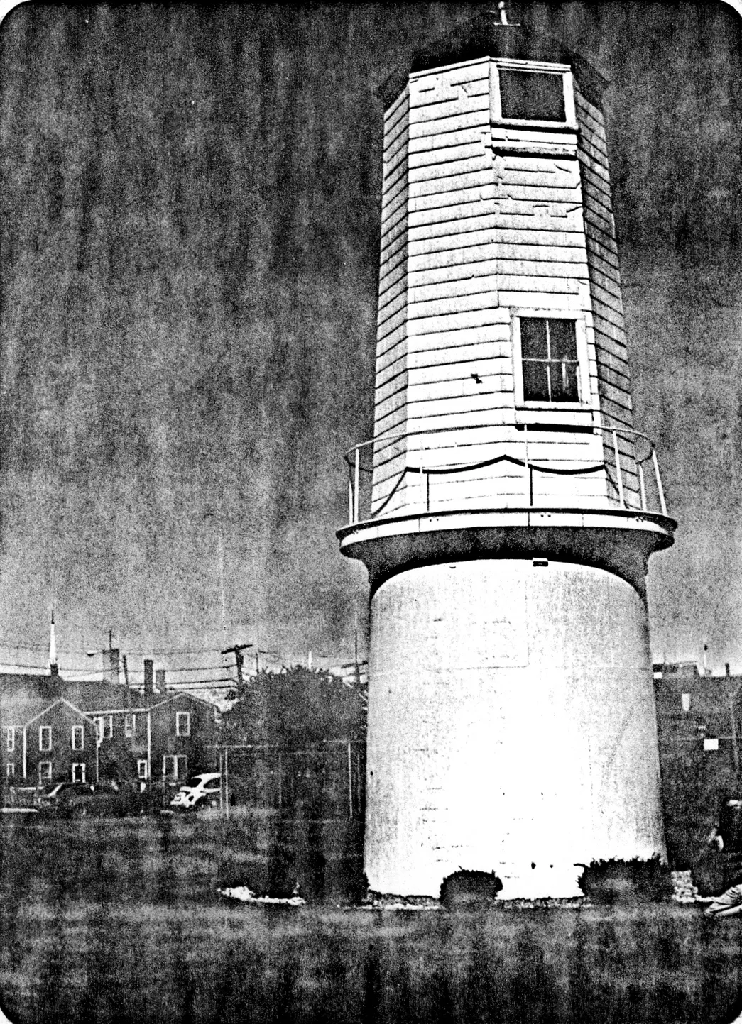
This is one of a pair. The state's inventory form says the two Newburyport Harbor Range Lights were built in 1873, after Robert Bayley sold the government a lot for the rear light on April 5 of that year: a pilot bringing a ship up the river lined this front light up with the tall brick rear light behind it, which you will pass later at 61½ Water Street, and held that line through the channel. The form says the pair is one of only three sets of range lights in Massachusetts and the best surviving example of the system, though this front light has been moved and altered; our research for this site says it was altered in 1905 and taken out of service in 1961. The old histories, which end in 1909, say nothing about it, and the lights they describe are the two small wooden lighthouses that Currier's History of 1906 says the General Court ordered built on the north end of Plum Island in 1787.
Sources: MACRIS inventory form · oldnbpt.com research · Currier, History of Newburyport, vol. 1 (1906), p. 67
Walk · 320 yardsFollow the track on past the light for about 50 yards to where it joins the Clipper City Rail Trail, and follow the trail about 95 yards to Water Street. Turn left onto Water Street and walk about 180 yards, with the river now on your left, to the foot of Federal Street, which comes down on your right. The ground between here and the water was the shipyard.
Stop 11 · 1776 · Lost
Where the frigate Boston was built
Federal Street has been King Street and Chandler's lane in its time, and Currier's History of 1906 says that a few years after 1764 Jonathan Greenleaf was building small vessels at its foot, “where the frigate Boston was built for the state of Massachusetts in 1776,” while Stephen and Ralph Cross, sons of the shipbuilder Ralph Cross, had a yard between the foot of the lane and Davenport's wharf, where they built the frigate Hancock the same year and the Protector in 1779. The three names went together: Currier's second volume says Greenleaf “was associated with Stephen and Ralph Cross in building the frigate Boston, mounting twenty-four guns, the Hancock, thirty-two guns, and the Protector, twenty guns.” Currier prints the War Office letter of July 1778 asking Messrs. Cross and Greenleaf to come to Boston and bring the draft of the frigate Boston, so that the new twenty-gun ship could be built from it. Men from the town sailed in her. Mrs. Smith says William Farris joined the frigate Boston at Newburyport as a midshipman in 1776, and Currier's second volume prints the petition of another old midshipman, who sailed in her under Captain Hector McNeil on the cruise of 1777 in company with the Hancock. The yard had an earlier moment: Currier says that in September 1765 a crowd hung an effigy of the stamp distributor from a large elm near the foot of Federal and Water Streets, left it a day, and burned it on a bonfire of tar barrels. Our research for this site says the ground later held a mast and spar yard and a coal yard, and that the building on it now dates from 2002.
Sources: Currier, History of Newburyport, vol. 1 (1906), pp. 41–42, 448, 588 · Currier, History of Newburyport, vol. 2 (1909), pp. 205, 209 · Smith, History of Newburyport (1854), p. 370 · oldnbpt.com research
Walk · 170 yardsTurn round and walk back up Water Street the way you came, with the river on your right, about 170 yards, to the corner of Independent Street on your left. The big brick buildings of the Tannery Marketplace stand on the site of the Globe Mills.
Stop 12 · 1846 · Lost
Globe Mills
The Globe Mills were the second of the steam cotton mills the town built to replace its lost shipping. Currier's second volume says Charles H. Coffin, Edward S. Lesley and Albert Currier were incorporated as the Globe Steam Mills on March 22, 1845, and that “Land was purchased on Federal street, extending to and including land on the corner of Independent and Water streets, and a four-story brick factory erected, in 1846.” Joshua Coffin's history of Newbury, printed while it was going up in 1845, says the Globe mills were planned for twelve thousand five hundred spindles and three hundred and twenty-five looms, to make seventy thousand yards of cloth a week with two hundred and seventy-five hands, burning a thousand tons of coal a year; Bayley and Jones count Captain Mark Symonds, a shipmaster, among its founders. The capital was cut in the business depression of 1857, Currier says, and in 1868 the company was reorganized as the Peabody Mills; Hurd's History of 1888 gives it four hundred looms then. Mill No. 2, on this corner of Independent and Water Streets, was built in 1881. The property went to Fall River owners in 1899 as the Peabody Manufacturing Company. Our research for this site says the main mill was two hundred and thirty-five feet long, was torn down in 1940 for a tannery, and that the tannery became the Tannery Marketplace in 1985.
Sources: Currier, History of Newburyport, vol. 2 (1909), pp. 151–152 · Coffin, Sketch of the History of Newbury (1845), p. 411 · Bayley and Jones, History of the Marine Society (1906), p. 375 · Hurd, History of Essex County, vol. 2 (1888) · oldnbpt.com research
Walk · 90 yardsContinue up Water Street about 90 yards. The brick commercial block on the river side, on your right, is 65 Water Street.
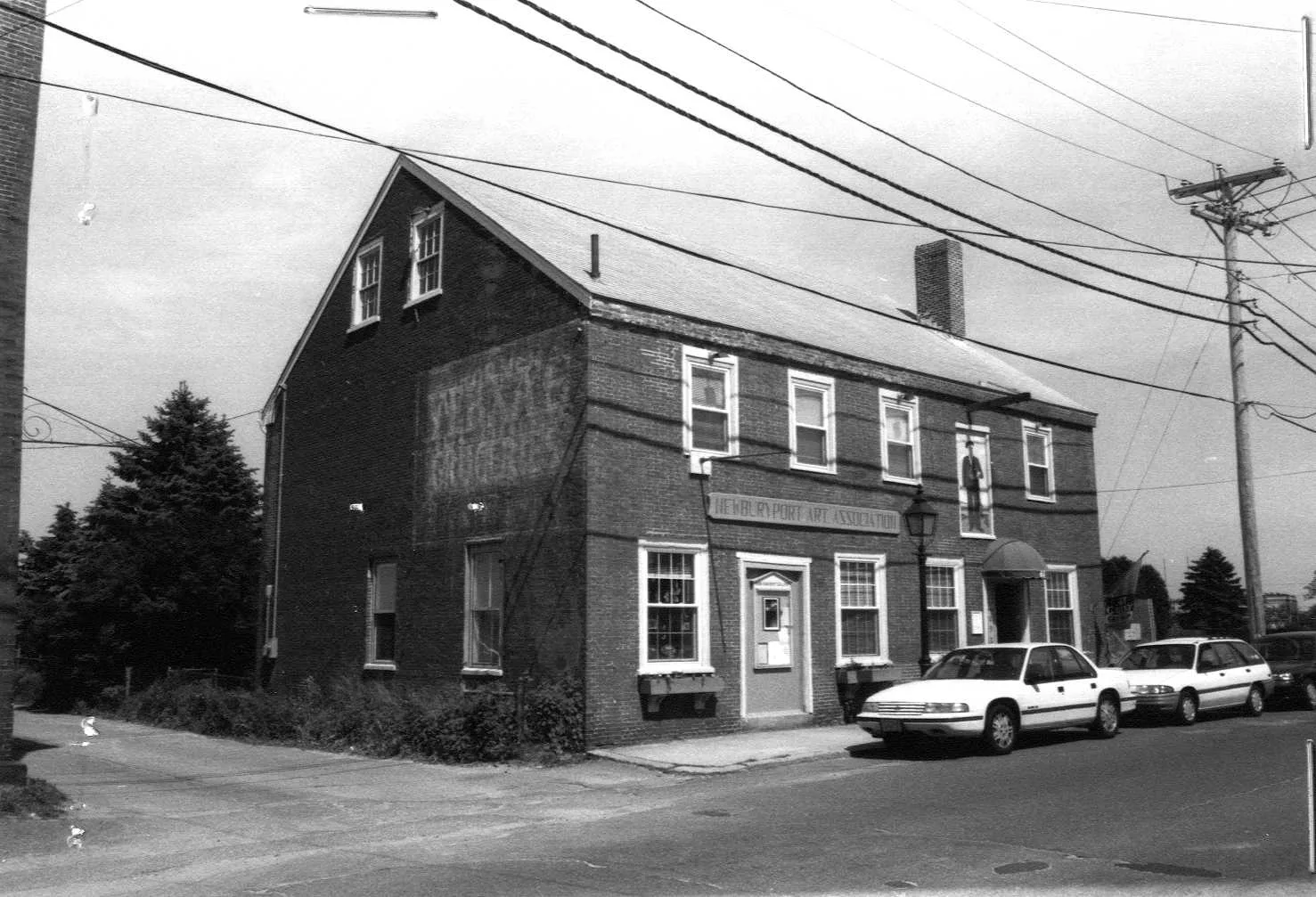
Stop 13 · 1815
65 Water Street
Capt. Anthony Gwynne Commercial Building
Photo: Massachusetts Historical Commission, MACRIS inventory
The state's inventory form calls this the Captain Anthony Gwynne commercial building and dates it 1815, and our research for this site, from a printed guide, keeps that date; it is now the home of the Newburyport Art Association. The Gwynn the histories know is earlier: Currier's “Ould Newbury” has Captain Anthony Gwynn as a warden and vestryman of St. Paul's from the church's first years in the 1740s, Joshua Coffin records his house struck by lightning in 1759, and Currier's second volume says that by 1784 his only sister, in Swansea in Wales, was selling his heirs' land on Federal Street to William Bartlet. What is certain about this building is its later tenant. The inventory form for the Custom House says the duties of the 1870s were paid mainly on sugar and molasses imported by the firm of Bayley and Sons “in what is now 65 Water Street,” so the counting room of the molasses trade was here, across the street from its wharf.
Sources: MACRIS inventory form · oldnbpt.com research · Currier, “Ould Newbury” (1896), pp. 397–400 · Coffin, Sketch of the History of Newbury (1845) · Currier, History of Newburyport, vol. 2 (1909), p. 234
Walk · a few stepsNext door, up the street, is 61 Water Street.
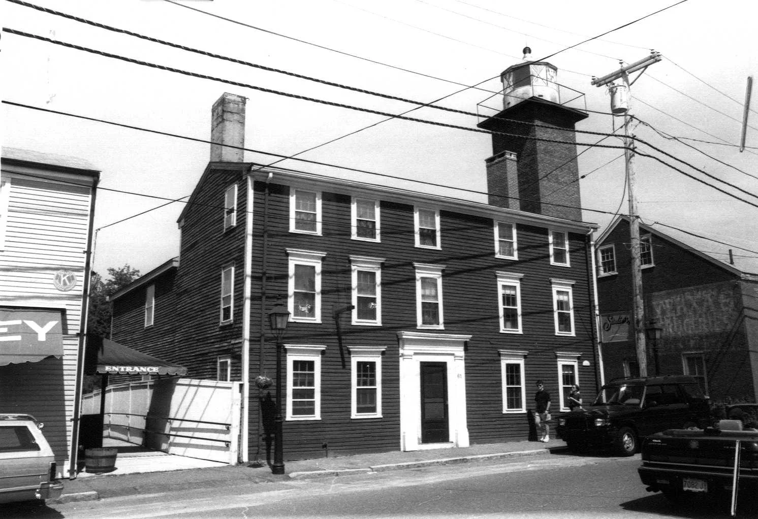
Stop 14 · c. 1790
61 Water Street
Anthony Davenport House
Photo: Massachusetts Historical Commission, MACRIS inventory
The state's inventory form calls this the Anthony Davenport House, a Federal building of about 1790, and our research for this site says the Davenport wharf you stood on earlier lay behind his house and store. Hurd's History of Essex County says Anthony Davenport, grandfather of Mayor Moses Davenport, was in business at the head of Ferry Wharf with his son John. Albert Hale's Old Newburyport Houses says an Anthony Davenport bought land on High Street in 1807 and built there soon after, which fits a merchant who had done well enough on the waterfront to move up the hill. The inventory form is all the histories give for the house itself.
Sources: MACRIS inventory form · oldnbpt.com research · Hurd, History of Essex County, vol. 2 (1888) · Hale, Old Newburyport Houses (1912), p. 55
Walk · a few stepsA few steps further, set back behind the houses on the river side, is the square brick tower of the rear range light, 61½ Water Street. look: The tower is fifty-three feet high; the iron lantern room on top has its landward windows boarded and its four windows toward Plum Island open.
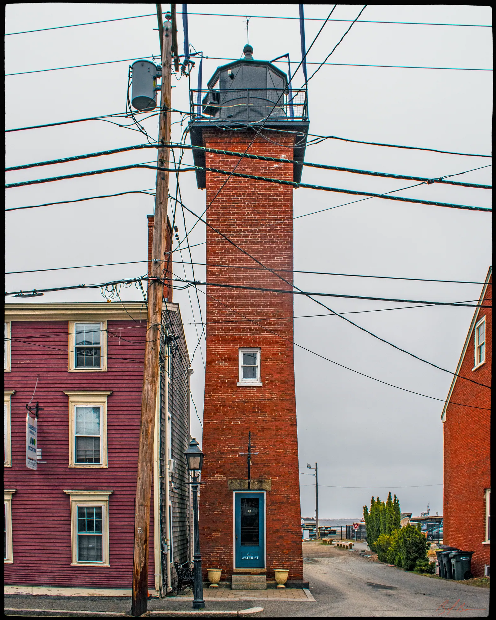
This is the other half of the pair you saw at the Coast Guard station. The state's inventory form says the lot was sold to the United States on April 5, 1873, by Robert Bayley, the molasses merchant, for a range light, and that the deed sent the land back to the Bayley heirs if the light was ever given up. The tower is brick, white-painted on the upper third of its river face with a stripe down its length so pilots could pick it out by day; inside, an iron stair winds up the walls to an iron lantern room with glass blocks in its floor to let light down the shaft. The form says the lamp burned coal gas until 1933, when it went electric, and that the light was discontinued in 1961. The land then reverted as the deed said, and the Bayley heirs sold the tower to Biagio DeMaggio, who ran the Range Lights Marina on Bayley's Wharf. The two lights together, the form says, are one of only three sets of range lights in the state, and the best of them.
Sources: MACRIS inventory form
Walk · 80 yardsWalk back down Water Street about 20 yards and turn right into Independent Street, the short street that climbs away from the river toward Middle Street. Walk up it about 55 yards and stop where you can see the row of small houses on both sides.
Stop 16
Independent Street
Emery calls this “Short, now Independent street,” and says Richard Emery, a shoemaker, built a house on it. Currier's “Ould Newbury” of 1896 says it was already “a way of one and a half rods wide” when Nathaniel Knapp, a caulker, bought the corner lot at Middle Street in 1736, and that on a stone post at that corner, at the top of the street, sits a cast-iron bombshell that his son and namesake brought home from the siege of Louisburg in 1758, where he served as soldier, carpenter and ship caulker; Hurd's History of 1888 repeats the story. The street stood just outside the 1811 fire, which Mrs. Smith says reached along Liberty Street to within one house of it. The state's inventory lists the houses you are looking at: number 2 of about 1775, number 4 and the Moses E. Wheeler house at number 10 of about 1800, and the William Stone and Samuel Robinson houses at 6 and 8 of about 1820, which the inventory still calls Georgian in form. Our research for this site sums it up as a street of small houses of the years between about 1775 and 1820, the homes of the men who worked the wharves below.
Sources: Emery, Reminiscences of a Nonagenarian (1879) · Currier, “Ould Newbury” (1896), pp. 483–489 · Hurd, History of Essex County, vol. 2 (1888) · Smith, History of Newburyport (1854), p. 185 · MACRIS inventory form · oldnbpt.com research
Walk · 230 yardsGo back down Independent Street to Water Street and turn left. Walk about 120 yards, past 61 and 65 Water Street again and the corner of Fair Street, and turn left into Pike Street. Stop after about 45 yards, by the corner lots.
Stop 17 · Lost
Hale Box Factory
The histories are silent on this one; it is our own research for this site that puts the Hale paper-box factory at Pike and Water Streets, in business from the early 1870s to 1951. It belongs with the comb shop at the foot of the street and the shoe shops Currier lists along Water Street: the small manufacturing that filled the waterfront after the ships were gone.
Sources: oldnbpt.com research
Walk · 120 yardsReturn down Pike Street to Water Street and turn left. After about 40 yards turn left again into Center Street, and stop a few steps up it.
Stop 18 · 1792 · Lost
Pearson’s Bakery
Emery, listing the bakers of the town in her girlhood, says “Messrs. Theodore and John Pearson's bakeries were on Centre street,” with Samuel Wheeler's bakehouse and store on the same street and Ebenezer Pearson's on Middle Street. Our research for this site says the business was founded in 1792, that it baked ship's bread, the hardtack that went to sea in every vessel on the river, and that in 1890 it joined the New York Biscuit Company, one of the firms that became Nabisco. Currier's “Ould Newbury” says the whole of Centre Street was laid in ashes in 1811, so whatever Emery saw here was built after that. Currier's History of 1906 says Liberty Street, at the top of this street, ran only from Federal Street to Centre Street when it was accepted in 1769, and was pushed through to Market Square after the fire.
Sources: Emery, Reminiscences of a Nonagenarian (1879), p. 228 · oldnbpt.com research · Currier, “Ould Newbury” (1896), pp. 627, 645 · Currier, History of Newburyport, vol. 1 (1906), p. 351
Walk · 150 yardsGo back to Water Street and turn left. Walk about 115 yards toward Market Square. Just before the square, the narrow lane climbing away from the river on your left is Elbow Alley.
Stop 19
Elbow Alley
Currier's “Ould Newbury” of 1896 found this lane in a deed. On December 9, 1749, Captain Patrick Tracy, the Irish-born shipmaster who prospered as a merchant and importer, bought about fifteen rods of land with a house and shop near the foot of State Street on the southwest side of Water Street, together with the right to a twelve-foot way from Water Street back to Joseph Arnold's land. Tracy lived there until he died, and the house burned in 1811. “The twelve-foot way mentioned in the deed is now known as Elbow alley,” Currier says: “It extends from Water Street, near its junction with Market Square, running at first in a southerly direction, then turning abruptly to the south-west, and so continuing until it reaches Liberty Street.” It was already called Elbow Lane when the new town, in 1764, voted to put one of its two writing schools “adjoining or near Cross street or Elbow Lane.” Our research for this site adds what the old histories do not: in the 1800s Black residents of the town ran businesses along the alley, among them the restaurant of Peter Romily, who lived from 1838 to 1898.
Sources: Currier, “Ould Newbury” (1896), ch. "Patrick Tracy" · Currier, History of Newburyport, vol. 1 (1906), p. 309 · oldnbpt.com research
Back to the start · 150 yardsCarry on along Water Street about 75 yards into Market Square, bear right across the square, and the Firehouse is in front of you, about 150 yards in all.
You have walked the length of what Emery called the “water side,” from the first wharf of 1656 to a coal office of 1890. Currier's History of 1906 says that in 1810 the merchants of this town owned forty-one ships, forty-nine brigs, four barks and fifty schooners, and most of them tied up along the mile you have just covered. The wharves are filled, the railroad that filled them is a trail, and the river is where it always was.
Sources for this walk
The script paraphrases and quotes these works, all of them out of copyright, and names each one as it goes. Page numbers are from the editions linked here. Where the script says “our research for this site,” the facts are from the building page it links to.
- John J. Currier, History of Newburyport, Mass., 1764–1905, vol. 1 (Newburyport: the author, 1906). archive.org/details/historyofnewbury01curr
- John J. Currier, History of Newburyport, Mass., 1764–1905, vol. 2 (Newburyport: the author, 1909). archive.org/details/historyofnewbury04curr
- John J. Currier, “Ould Newbury”: Historical and Biographical Sketches (Boston: Damrell & Upham, 1896). archive.org/details/ouldnewburyhisto00curr
- Joshua Coffin, A Sketch of the History of Newbury, Newburyport, and West Newbury, from 1635 to 1845 (Boston: Samuel G. Drake, 1845). archive.org/details/sketchofhistoryo00coff_0
- E. Vale Smith, History of Newburyport; from the Earliest Settlement of the Country to the Present Time (Newburyport, 1854). archive.org/details/historyofnewbury00blake
- Sarah Anna Emery, Reminiscences of a Nonagenarian (Newburyport: William H. Huse, 1879). archive.org/details/reminiscencesofn00emer
- William H. Bayley and Oliver O. Jones, History of the Marine Society of Newburyport, Massachusetts, from Its Incorporation in 1772 to the Year 1906 (Newburyport, 1906). archive.org/details/historyofmarines00baylrich
- Albert Hale, comp., Old Newburyport Houses (Boston: W. B. Clarke Co., 1912). archive.org/details/cu31924015356714
- D. Hamilton Hurd, comp., History of Essex County, Massachusetts, vol. 2 (Philadelphia: J. W. Lewis & Co., 1888). archive.org/details/historyofessexco02hurd
- Massachusetts Historical Commission, Massachusetts Cultural Resource Information System (MACRIS), Newburyport inventory forms. mhc-macris.net
- Biff Bouse, oldnbpt.com building pages (own research from deeds, Sanborn maps and newspapers). oldnbpt.com
More walks: State Street and Market Square · Green Street, Brown Square and Pleasant Street · High Street: Down Along and the Ridge · Federal, Spring and Middle Streets · Joppa: The Oldest Houses · Joppa: The Fishing Village · Along the River: The North End Shipyards · The Rail Trail: Mills, Ropewalks and Old Hill · Newburyport in the Civil War · Churchyards and Burying Grounds