Walking tours · Downtown · 23 stops
State Street and Market Square
A short loop up one side of State Street and down the other, from the old market place by the river to the Dalton House and back. This was Fish Street when the town was founded, the street where the shops, the tavern, the banks and the first library all stood, and the brick blocks you walk past are the rebuilding after the Great Fire of 1811.
- Length
- About 1 mi, a loop
- Time
- About 70 min, with the reading
- Start and finish
- Market Square, at the foot of State Street
Before you set off
State Street was Fish Street, or Greenleaf's lane, in the deeds of the 1740s, and when Newburyport was set off from Newbury in 1764 it was already the town's main street. John J. Currier's History of Newburyport, published in 1906, puts the first meeting house of 1725 on a triangular lot at the foot of it, where Market Square is now, and says that most of the shops of the town stood around that meeting house. Sarah Anna Emery, who was born in 1787 and wrote her Reminiscences of a Nonagenarian in 1879, remembered the street before the fire as “two-storied wooden buildings, mostly painted pale yellow, with green blinds or shutters,” with a few lofty brick blocks among them.
On the night of May 31, 1811, most of that burned. The fire started in a stable on what is now Inn Street and took the lower part of State Street, the square and everything between there and Middle Street; Caleb Cushing, writing in 1826, put the burnt district at sixteen and a half acres. What you see on the lower street today is what the town built back in brick, and above Pleasant Street the older houses that the fire never reached: the Tracy house that became the library, and the Dalton House, where Washington ate breakfast.
Numbers follow the walk. The line is the route along the streets, back to where you started.
Read it aloud as you go: each stop begins with where to walk and where to stand, then what the old histories say about the place. The sources are named as you read and listed in full at the end.
StartThe loop begins in Market Square, the open brick-paved space at the foot of State Street beside the river, where State Street, Merrimac Street and Water Street meet. Stand near the middle of the square with the river behind you and State Street running uphill in front of you.
Stop 1
Market Square
You are standing where Newburyport began as a town. Currier's History of 1906 says the Third Parish of Newbury built its meeting house here in 1725, on a triangular lot by the riverside, and that when the town was incorporated in 1764 the meeting house in Market square was inside the new bounds. Most of the shops were around it; in 1773 a watch house was built on the northeasterly side of the square. Sarah Anna Emery remembered running over to it as a small child on a warm moonlit evening: “A large, unpainted building, its heaven-pointing spire, white in the moonbeams rose before us.”
Currier says the land was bought by the town and laid out as a way called Market square in 1800; the last services were held on September 27, 1801, and the building came down in the following ten days. The selectmen were told to dig a well and set up a pump. Emery says the pump stood “very nearly on the site of the pulpit of the old meeting-house,” and Currier adds that the weathercock from the old spire was set on the new one on Pleasant Street in 1801. One more name belongs to the square: the second volume of Currier's history, published in 1909, says Albert Pike came to Newburyport as a child in 1814, went to the town's schools and taught a private school here in 1830 before walking most of the way to St. Louis; our own research for this site follows him on to the Confederate army.
Sources: Currier, History of Newburyport, vol. 1 (1906), pp. 29, 68, 139, 255 · Currier, History of Newburyport, vol. 2 (1909), p. 321 · Emery, Reminiscences of a Nonagenarian (1879) · oldnbpt.com research
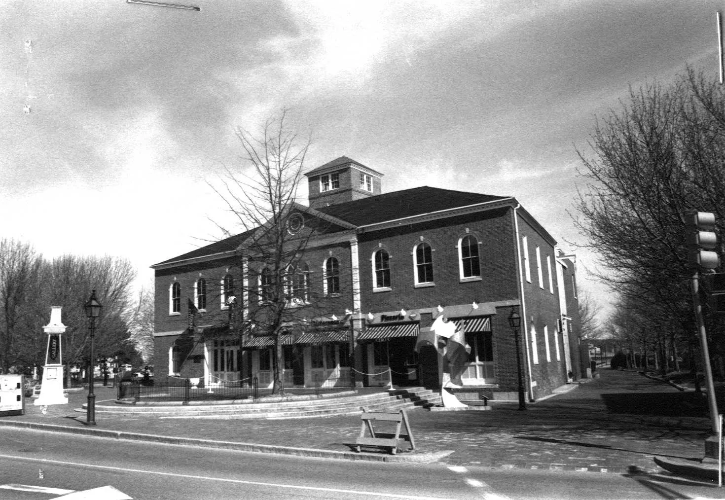
Walk · a few stepsTurn to face the river. The long brick building across the end of the square, a few steps away, is the old Market House, now the Firehouse.
Stop 2 · c. 1825
1–3 Market Square
Old Market House (the Firehouse)
Photo: Massachusetts Historical Commission, MACRIS inventory
Currier's History of 1906 says that after the fire all the buildings on the south and west sides of the square were gone and some lots lay empty for ten or fifteen years. Meanwhile “the erection of a market house for the accommodation of dealers in meat, poultry, butter and cheese was strongly urged.” Emery remembered what stood here before: a row of low, open butchers' shambles. In 1822 a committee found the ground was a town landing laid out in 1771, with a disputed claim on it, and the town cleared the shambles anyway; on August 5, 1822, authorized the selectmen “to build a Market house of brick, one story high, on the site where the shambles lately stood.”
Currier adds that the hall upstairs was not finished until 1834 and 1835; the annual town meeting of March 23, 1835, was the first held “in the new hall over the market house.” Mrs. E. Vale Smith's history of 1854 has the ladies of the town presenting Colonel Cushing with a gold ring at Market Hall before he led his regiment to the Mexican War. The state inventory form dates the building to about 1825.
Sources: Currier, History of Newburyport, vol. 1 (1906), pp. 139–140, 188–189 · Emery, Reminiscences of a Nonagenarian (1879) · Smith, History of Newburyport (1854), p. 235 · MACRIS inventory form
Walk · 110 yardsLeave the square by turning left into Merrimac Street, and after a few steps carry straight on into Inn Street, the pedestrian mall that climbs away from the river parallel to State Street. Walk about 110 yards up the mall and stop.
Stop 3 · 1811 · Lost
Where the Great Fire of 1811 began
Inn Street was Mechanics' Row in 1811, a narrow lane running from Market Square up to Threadneedle Alley, and this is where the Great Fire began. Currier's History of 1906 tells it plainly. Friday, May 31, 1811, about half past nine in the evening, with a strong westerly wind and no rain for weeks, the cry of fire went up. “The fire began in an unoccupied stable on Inn street, then called Mechanic's row, and continued to rage until two o'clock in the morning,” burning nearly two hundred and fifty shops and houses between State and Fair Streets and between Middle Street and the river. Caleb Cushing in 1826 measured the ruin at sixteen and a half acres and said no part of the town was more compactly built or held more valuable property. Mrs. Smith's history of 1854 says the selectmen offered a thousand dollars for the incendiary and never found him.
Currier's “Ould Newbury,” published in 1896, prints an account by a gentleman who was out that night: “The incessant crash of falling buildings, the roaring of chimneys like distant thunder, the flames ascending in curling volumes from a vast extent of ruins, the air filled with a shower of fire.” Currier also says that George Peabody, afterwards the London banker, was then a clerk in a dry-goods store on State Street and was one of the first to give the alarm; he left for Georgetown the next spring. Emery, who was twenty-three that year, lists what went: nearly every dry-goods store, four printing offices, the custom house, the post office, two insurance offices, the Baptist meeting house and the town library.
Sources: Currier, History of Newburyport, vol. 1 (1906), pp. 152–153 · Currier, “Ould Newbury” (1896), ch. "The Great Fire" · Cushing, History and Present State of Newburyport (1826) · Smith, History of Newburyport (1854), p. 101 · Emery, Reminiscences of a Nonagenarian (1879)
Walk · a few stepsContinue up Inn Street a few more steps and turn left into Threadneedle Alley, the narrow lane that cuts through to State Street. Stop in the alley.
Stop 4
Threadneedle Alley
This lane is older than the town. “Ould Newbury” traces it in the deeds: in 1743 William Davenport, a wood carver, bought a lot bounded on the west by a way one rod wide, now Threadneedle Alley, and on the north by a way a rod and a half wide, now Inn Street. Davenport had bought the house next to it on Fish Street in 1741, and in 1762, Currier says, he made extensive alterations and opened it as the Wolfe Tavern, under a sign of General Wolfe, the commander at Quebec, which Currier thinks the carver made himself. Currier's History of 1906 says that in 1764 “Wolfe tavern, then standing on the corner of Fish, now State, street and Threadneedle alley, was a famous resort for travellers.” The Marine Society met there once a month for many years, the Newburyport Marine Insurance Company held its first stockholders' meeting there in 1799, and Emery says the Eastern Stage Company's coaches left from its door.
Emery remembered it at the end: “a two-story, wooden building, somewhat dingy with age,” with a flight of steps up to the door and the sign of General Wolfe swinging from a tall post, kept for years by Moses Davenport and latterly by Prince Stetson. It burned on the night of the fire, and Currier says Anthony and Moses Davenport built brick stores on the site; Stetson moved the tavern first to Colonel Bartlett's house at State and Temple and then, in 1814, to the corner of State and Harris, where this walk will find it again.
Sources: Currier, “Ould Newbury” (1896), ch. "Wolfe Tavern" · Currier, History of Newburyport, vol. 1 (1906), pp. 385–386, 519 · Currier, History of Newburyport, vol. 2 (1909), p. 128 · Emery, Reminiscences of a Nonagenarian (1879), pp. 229–230
Walk · 90 yardsWalk down the alley to State Street and turn left, downhill toward the square. Keep to this side, the left-hand side going down, for about 90 yards. The three-storey brick block with the stone tablet set between the second and third floors is the Marine Society Building, numbers 10 to 16. look: The stone tablet between the upper windows names the Marine Society and its founding year, 1772.
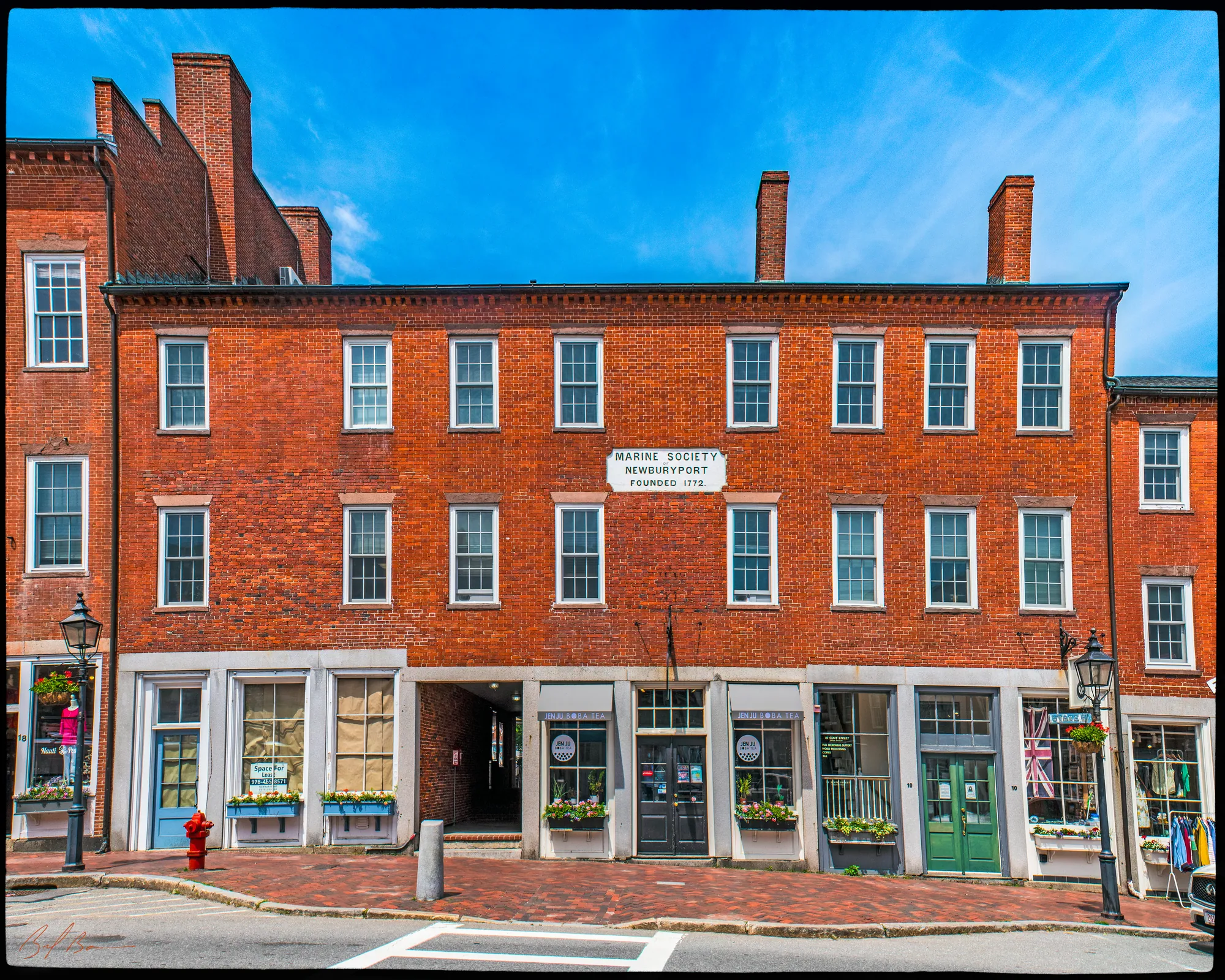
The state inventory form believes this block went up soon after the fire, like its neighbours, and that in its early years it held the dry-goods stores of Abraham Wheelwright, Moses Davenport, William Thompson and Benjamin Poore. The Marine Society came here in 1851. Bayley and Jones's History of the Marine Society, published in 1906, prints the committee's report of May 29 that year: they had “purchased a three story store on State street belonging to the estate of Abraham Wheelwright, for which they had paid $3000,” the ground floor being let for a hundred and eighty-five dollars a year, and the society voted to fit up the second and third stories for its meetings.
The society itself is older than the building by eighty years. Currier's second volume says it was organized on November 5, 1772, in Captain Benjamin Rogers's house on what is now Winter Street, afterwards met at the Wolfe Tavern, and was incorporated in 1777, a charity for distressed mariners and their families that also made itself an authority on pilots, lighthouses and buoys. The inventory form adds that the society kept a museum of curiosities brought home by its members upstairs, that the hall was called Concert Hall by the 1860s, and that the society sold the building in the early twentieth century. The form also notes that the brickwork was covered with mastic for years and uncovered in 1902, and that the storefronts were put back to something like their old form in the 1970s.
Sources: Bayley and Jones, History of the Marine Society (1906), p. 213 · Currier, History of Newburyport, vol. 2 (1909), p. 128 · MACRIS inventory form
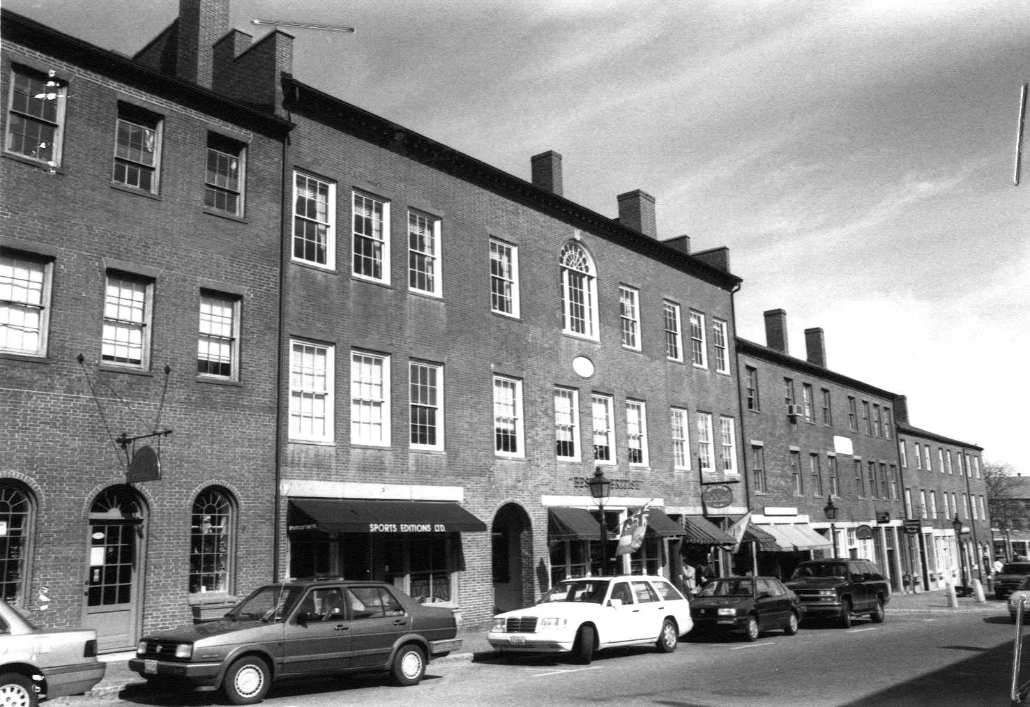
Walk · a few stepsTurn round and walk back up State Street. The next block up on your right, joined to the Marine Society Building, is the Phenix Building, numbers 18 to 26.
Stop 6 · c. 1811
18–26 State Street
Phenix Building
Photo: Massachusetts Historical Commission, MACRIS inventory
A Phoenix Building stood here before the fire too, and Emery describes it: “an imposing four-storied brick structure, a fine specimen of architecture, with handsome copings, and between the upper windows, arched niches ornamented with statues.” It held the custom house, the post office and the Phoenix Insurance office, with Madison Hall on the top floor. Joshua Coffin's history of 1845 prints the newspaper account of the fire: Blunt's building and the Phenix building, the two tallest in the street, were hoped to be a barrier, but the wind changed and carried the flames on to them. “State street at this time presented a spectacle most terribly sublime!”
The block that replaced it was up quickly; the inventory form dates it to about 1811, and Currier's History of 1906 has Nathaniel Foster opening a clock and watch shop at No. 2 Phoenix building in 1818 and St. Mark's and St. John's Masonic lodges leasing Phenix Hall in 1825. A sea captain, Lawrence Brown, remembered clerking for Moses Davenport “on State street in the Phoenix building” for a dollar a week before he went to sea, according to Bayley and Jones, and Currier says St. Mark's Lodge was still meeting in Phenix Hall in 1906.
Sources: Emery, Reminiscences of a Nonagenarian (1879), p. 229 · Coffin, Sketch of the History of Newbury (1845) · Currier, History of Newburyport, vol. 1 (1906), pp. 123–124, 169 · Bayley and Jones, History of the Marine Society (1906), p. 416 · MACRIS inventory form
Walk · 90 yardsContinue up State Street on the right-hand side for about 90 yards, past Threadneedle Alley, to the corner of Pleasant Street. The three-storey brick block on the corner, with the cut-away corner doorway and the curved brackets above it, is number 58. look: The gable end faces Pleasant Street, with a fanlight set in the peak.
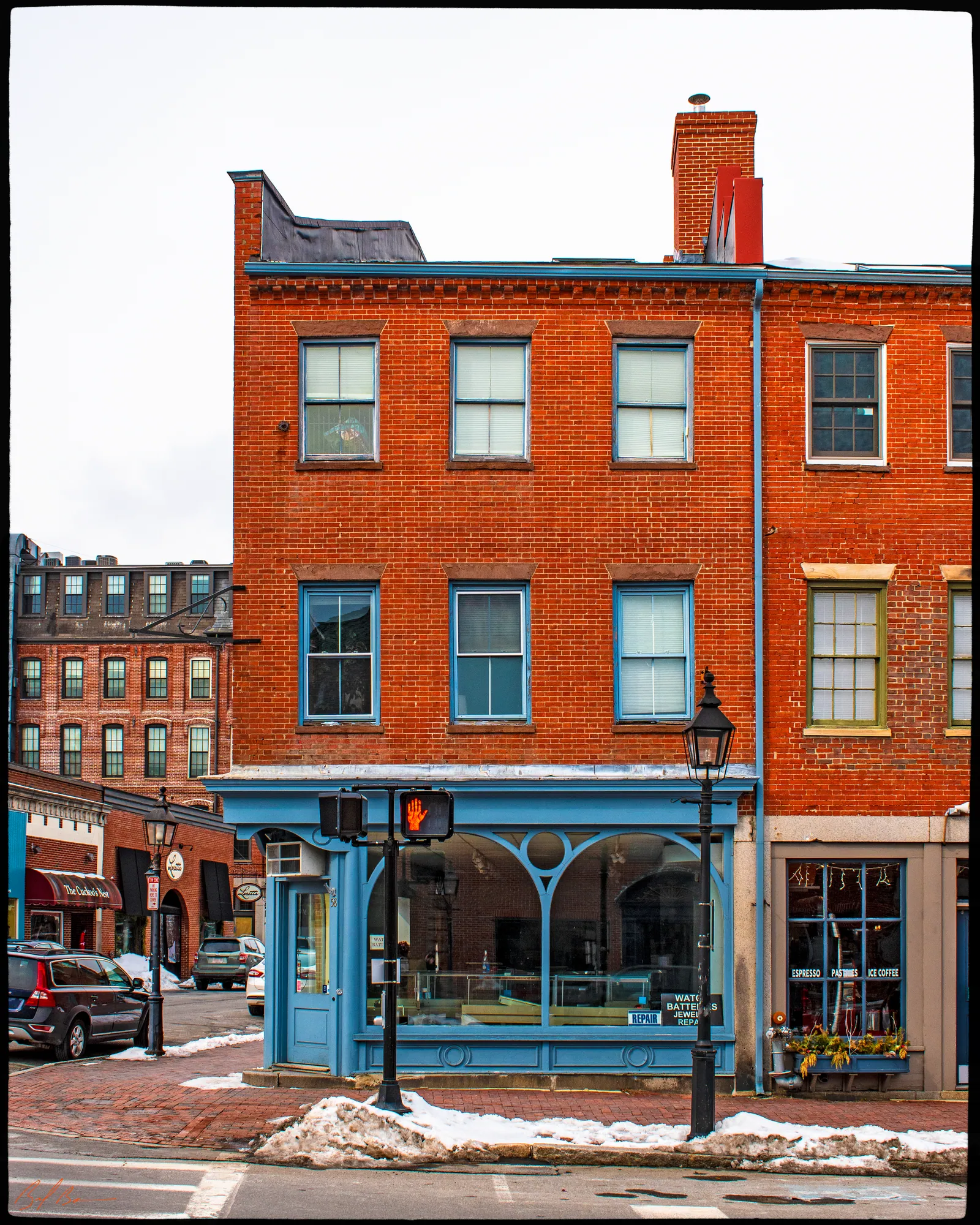
This corner was the start of Cornhill, the name for the upper side of State Street between Threadneedle Alley and Pleasant Street. Emery explains the name: “before the street had been graded this was quite an eminence, high and warm land ; for years it was planted with corn, and thus obtained its name.” In her girlhood a big three-storey wooden block stood here, with Arthur Gilman's dry-goods store on the corner, tailors and lawyers upstairs and a hairdresser at the lower end. That block burned in 1811. The state inventory form, citing a reminiscence in the Herald of 1883, says the present brick block was built in 1811 and that the same Arthur Gilman, father of the architect Arthur Gilman, was its first tenant from 1812 to 1834.
Currier's second volume says that in 1815 John Porter, an insurance broker, had his office at No. 14 Cornhill. The inventory form carries the story on: John Buntin's dry-goods store from about 1848 to 1883, the corner storefront remodelled late in the century, and from 1922 Eaton's Drug Store, founded at 1 State Street in 1900, which stayed here into the 1980s and gave the building the name it still carries.
Sources: Emery, Reminiscences of a Nonagenarian (1879), p. 229 · Currier, History of Newburyport, vol. 2 (1909) · MACRIS inventory form
Walk · a few stepsAt the corner, turn into Pleasant Street beside the Eaton Drug block and take a few steps along it, so that you can see the upper corner of Pleasant and State. Dr. Sawyer's house stood on that upper corner, across Pleasant Street from number 58.
Stop 8 · 1766 · Lost
Dr. Micajah Sawyer House
Dr. Micajah Sawyer was one of the four doctors living in the new town in 1764, according to Currier's second volume: born in Newbury in 1737, a Harvard graduate of 1756, a founder of the American Academy of Arts and Sciences in 1780. Currier says that in 1766 he bought land here on the northwest side of Fish Street and built a house that was still standing in 1909, though much changed: when Pleasant Street was laid out part of the lot was taken for the road, and fifty or sixty years later “the house was raised from the level of the street to its present position, a basement or lower story added, and the entire building converted into offices and stores.” Emery remembered “Dr. Micajah Sawyer's handsome residence” on the upper corner of Pleasant, opposite the Cornhill block.
Currier quotes Eben F. Stone on the doctor's two daughters and a letter of 1803 from a woman who had been to parties at Jefferson's White House: “she had seen nothing in Washington equal in style and elegance to the parties given by the Sawyer girls in Newburyport.” Dr. Sawyer died in 1815. The house itself is gone; our own research for this site records it as lost.
Sources: Currier, History of Newburyport, vol. 2 (1909), pp. 291–293 · Currier, History of Newburyport, vol. 1 (1906), p. 77 · Emery, Reminiscences of a Nonagenarian (1879), p. 229 · oldnbpt.com research
Walk · 80 yardsGo back to State Street and continue uphill on the right-hand side for about 50 yards. The tall, ornate Victorian bank with the arched windows, on your right nearly opposite Charter Street, is the Five Cent Savings Bank, numbers 72 to 80.
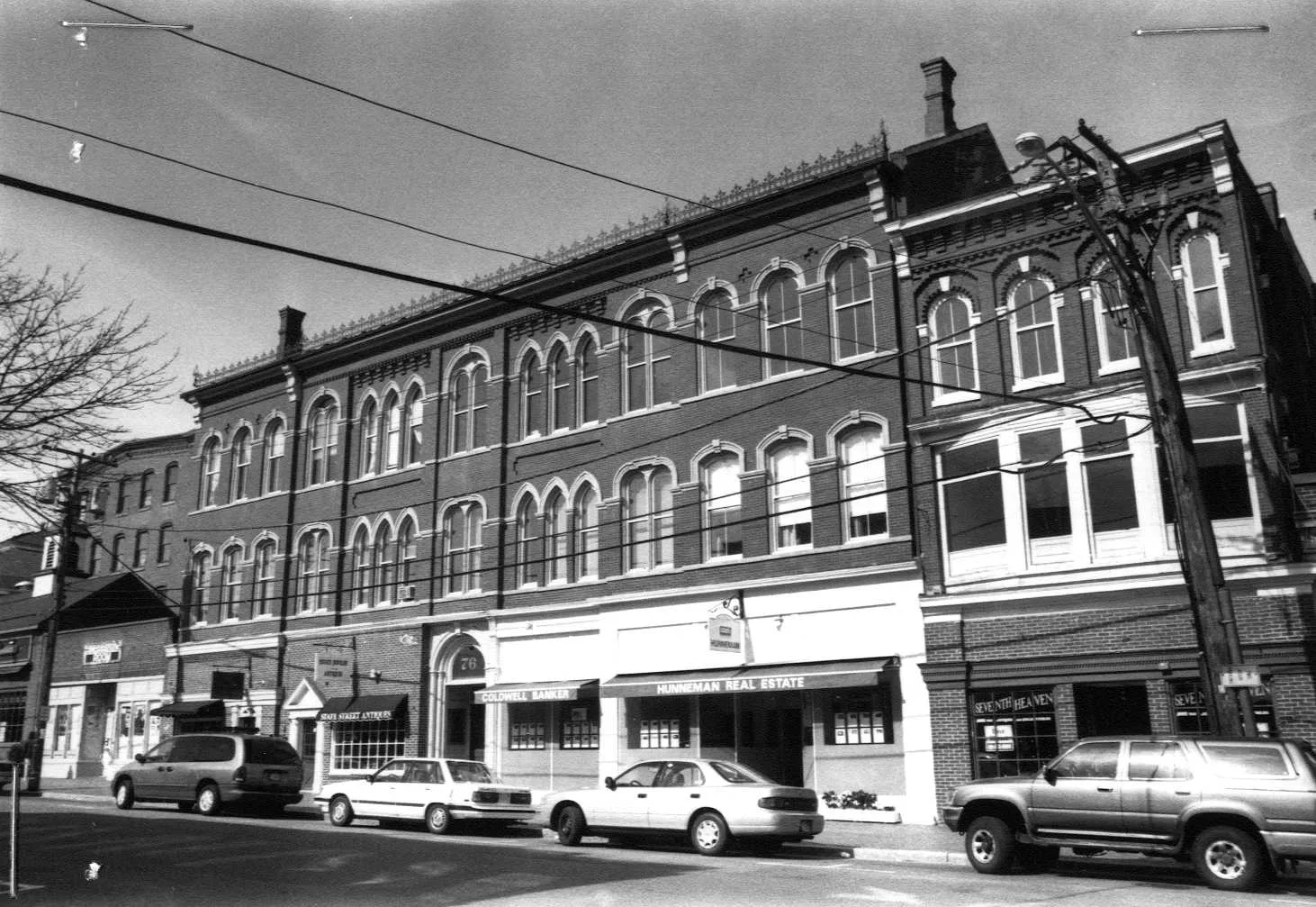
Stop 9 · c. 1874
72–80 State Street
Newburyport Five Cent Savings Bank
Photo: Massachusetts Historical Commission, MACRIS inventory
The second volume of Currier's history tells the bank's story. On April 24, 1854, Dudley D. Tilton, John Balch, John Porter and others were incorporated as The Newburyport Five Cents Savings Bank and “were authorized to receive on deposit sums as small as five cents.” It opened for business on June 19 that year in rooms over Joseph A. Frothingham's store on State Street, moved a few years later to rooms over the Mechanicks Bank at No. 53, and in 1873 bought land here; the next year, Currier says, the bank put up its building on the northwesterly side of the street, nearly opposite Charter Street, and was still here in 1909. The state inventory form dates it to about 1874 and calls the style Victorian Eclectic, which is as good a name as any for the mixture you see.
Sources: Currier, History of Newburyport, vol. 2 (1909), p. 171 · MACRIS inventory form
Walk · 60 yardsContinue up State Street about 60 yards on the same side. The large brick house set back behind a low granite wall and iron pickets, with a columned porch and a lawn in front, is the Newburyport Public Library, number 94, built as the Tracy house. look: The marble panel between the centre windows reads “Public Library and Reading Room.”
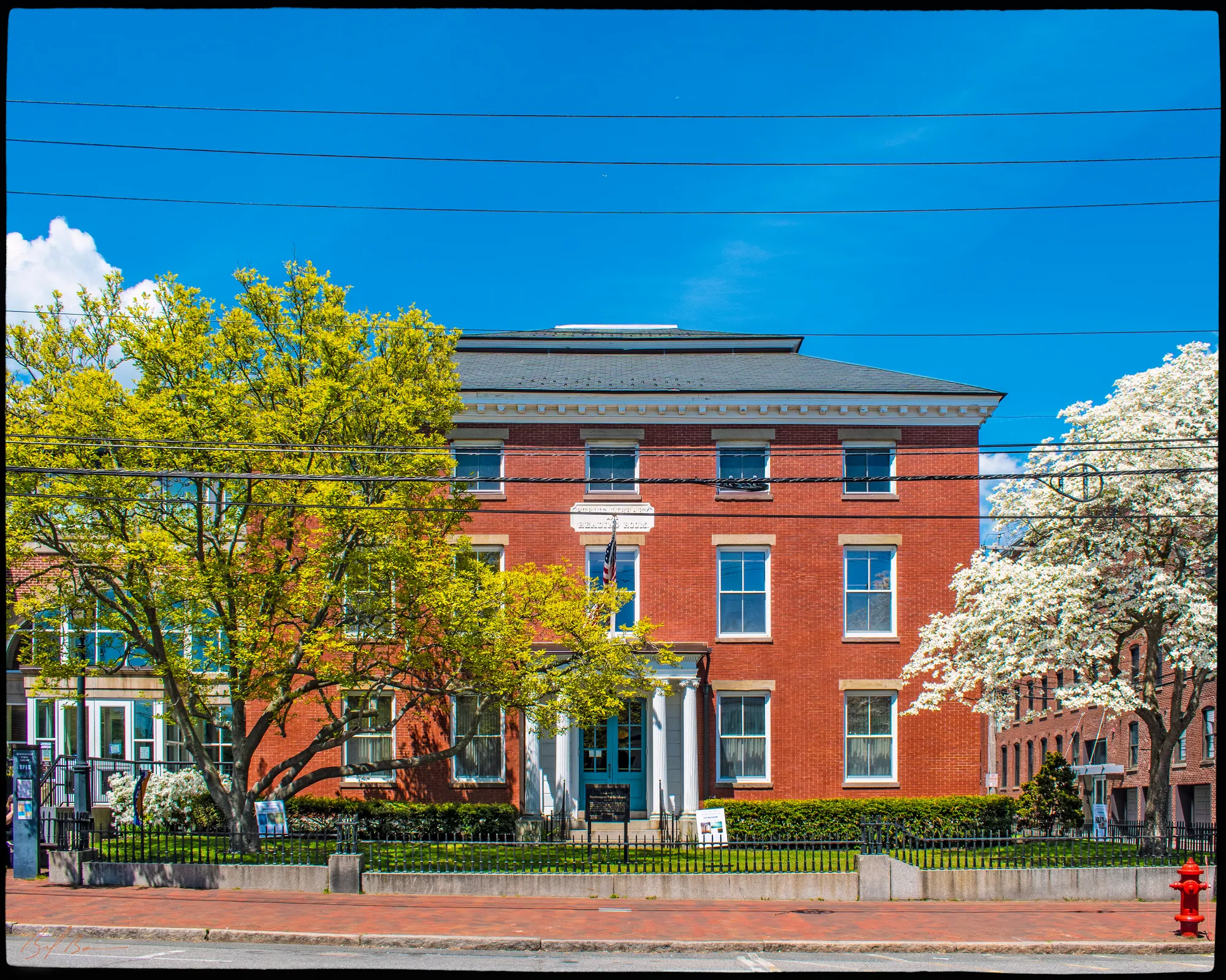
Albert Hale's Old Newburyport Houses, the 1912 book of photographs, says this land was bought in 1771 by Patrick Tracy, who built a brick house here for his son Nathaniel. “Ould Newbury” says Nathaniel Tracy was the principal owner of twenty-four privateers in the Revolution and a hundred and ten merchant vessels, and that at the end of the war only thirteen were left. His brother-in-law Jonathan Jackson was living here when Washington came through New England, and Currier is precise: “Washington arrived in Newburyport Friday, Oct. 30, 1789, about four o'clock p. m. He passed the night in the Tracy house,” after an address written by the young John Quincy Adams.
Hale's owner list runs through Timothy Dexter, who held the house from 1791 to 1796, to James Prince, who bought it in 1800. Currier prints the advertisement of 1807 in which Jacob Coburn opened it as the Sun Hotel, and Prince's own notice of 1814 offering it for sale with its garden laid out in box-trimmed squares and its ninety bushels of pears. The sale fell through, and so in 1824 Prince was still here when Lafayette came: “The same apartments that Washington occupied in 1789 were offered to the committee appointed to make arrangements for the reception of La Fayette.” Currier's second volume says Josiah Little gave the city five thousand dollars for a free library in 1854; the Tracy house was bought and remodelled for it in 1864, William C. Todd suggested the free reading room in 1870, and Michael H. Simpson paid for the reading-room addition of 1882. The inventory form adds that the 1865 alterations were by the Newburyport-born architect Arthur Gilman, and that the Ionic porch, the mastic coating and later the brick veneer all date from the library years.
Sources: Hale, Old Newburyport Houses (1912), p. 35 · Currier, “Ould Newbury” (1896), ch. "Public Library Building" · Currier, History of Newburyport, vol. 2 (1909), pp. 176, 398 · MACRIS inventory form
Walk · a few stepsWalk on a few steps to the newer part of the library, on the corner of Harris Street. This is the site of number 96, the Corliss Memorial Building.
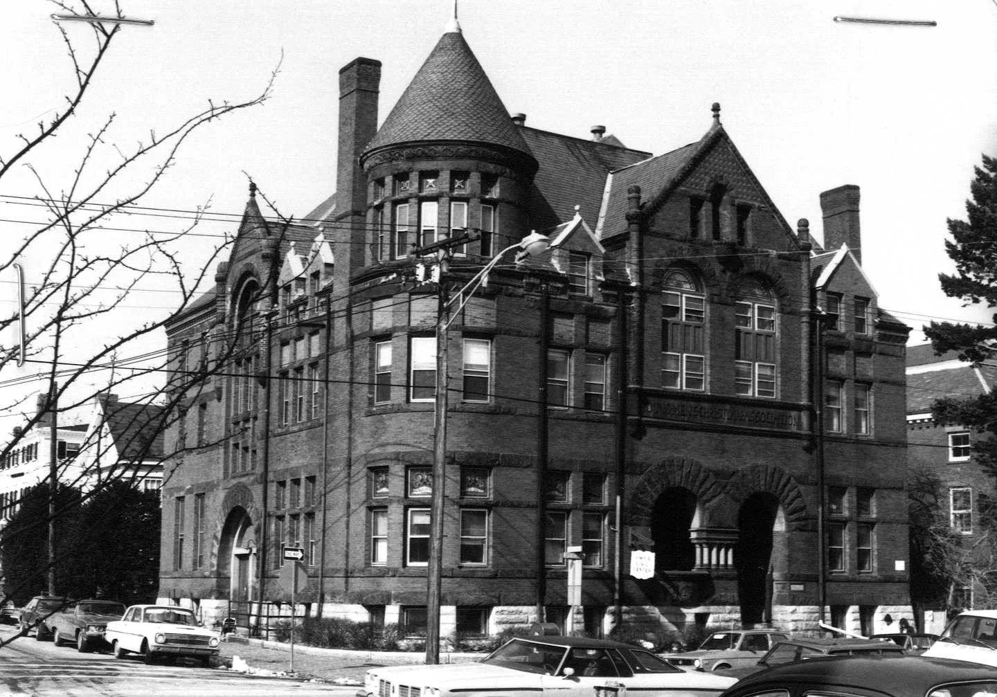
Stop 11 · c. 1891 · Lost
96 State Street
Corliss Memorial Building
Photo: Massachusetts Historical Commission, MACRIS inventory
Nothing of it is left, but it was a landmark for a century. Currier's History of 1906 says the Young Men's Christian Association laid the corner-stone of its building here, at the corner of State and Harris Streets, on June 21, 1890, with an address by Bishop Thomas M. Clark of Rhode Island. The building was put up by the family of the late George H. Corliss of Providence as a memorial, and dedicated on April 17, 1891: “a substantial structure of brick and stone, conveniently located, and exceedingly attractive from an architectural point of view.” Currier's second volume says the association had been founded in 1876 in rooms over the corner of State and Essex Streets and had moved twice before it bought this lot in 1888.
Emery, writing of the years around 1800, says that on this corner of Harris Street lived Master Pike, in a large, substantial house. The state inventory form calls the Corliss building Richardsonian Romanesque; it burned in 1987, and the library's latest addition now covers the site.
Sources: Currier, History of Newburyport, vol. 1 (1906), pp. 247–248 · Currier, History of Newburyport, vol. 2 (1909), p. 145 · Emery, Reminiscences of a Nonagenarian (1879), p. 229 · MACRIS inventory form
Walk · 140 yardsCross Harris Street at the corner and stop on the far, upper corner, still on the right-hand side of State Street. The Merrimac House, the last home of the Wolfe Tavern, stood here.
Stop 12 · 1807 · Lost
Merrimac House and Wolfe Tavern
“Ould Newbury” picks up the tavern's story after the fire: “On the corner of State and Harris Streets was a spacious brick house owned and occupied by Colonel John Peabody, uncle of the eminent banker, George Peabody, of London.” Emery lists it with Joshua Carter's next door as the new and palatial residences of the upper street. Peabody had built it at great expense, Currier says, and after his losses in the fire he left for Georgetown; the house passed in 1812 to Ebenezer Wheelwright and Thomas M. Clark, who sold it on January 1, 1814, to Benjamin Hale for seven thousand five hundred dollars. It was altered for a hotel, and the Wolfe Tavern moved in with a new sign of General Wolfe painted by Moses Cole. For a time, Currier says, the sign was taken down and the house renamed the Merrimac House; in 1887 the old name came back, and in 1896 “Renovated and improved, the ancient tavern still furnishes entertainment for man and beast.”
Our own research for this site dates the house to 1807, and records that the hotel closed in 1951 and was torn down in 1954.
Sources: Currier, “Ould Newbury” (1896), ch. "Wolfe Tavern" · Emery, Reminiscences of a Nonagenarian (1879), p. 229 · oldnbpt.com research
Walk · 230 yardsContinue up State Street on the same side for about 90 yards. The three-storey brick Federal house with the fanlight doorway, on your right, is number 100.
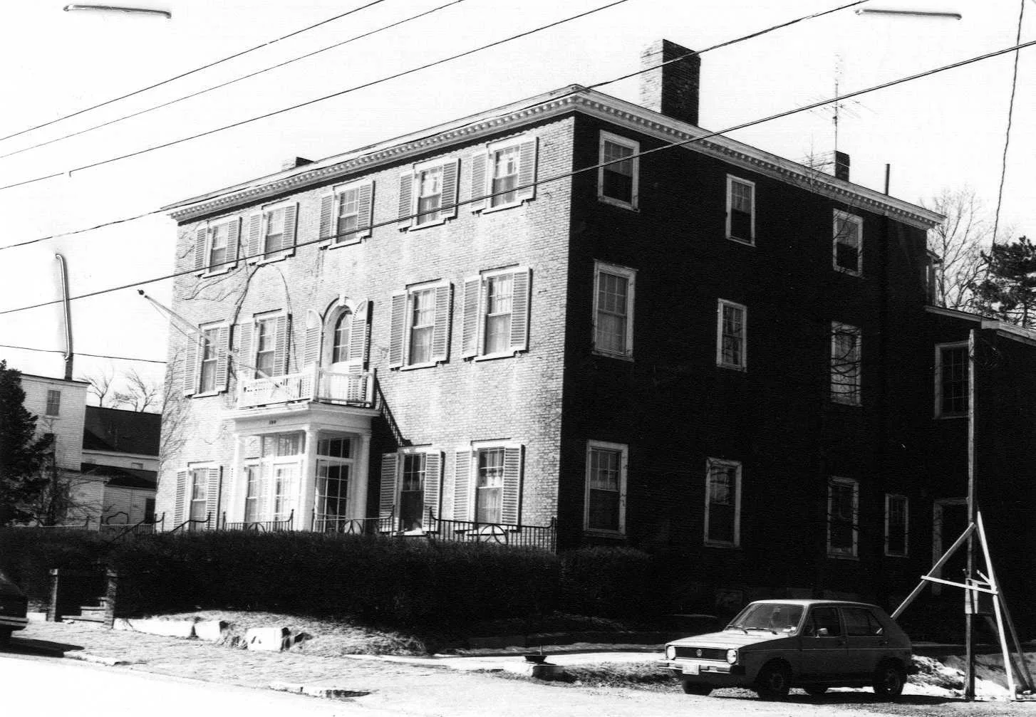
Stop 13 · c. 1800
100 State Street
Joshua Carter–Enoch Tilton House
Photo: Massachusetts Historical Commission, MACRIS inventory
Hale lists this as the Tilton House and puts it at 102 State Street: the land was bought by Joshua Carter in 1795. “The house was subsequently built by him and sold in 1823 to Francis Todd who held it until 1850.” Enoch Tilton bought it then, and his daughters were living here in 1912. Carter was a considerable man in the town: Currier's two volumes have him as a selectman signing the assize of bread in 1793, a merchant whose brig Mary was among the Newburyport vessels captured in 1794, an incorporator of the Locks and Canals on the Merrimack in 1792, of the Newburyport Bank in 1803 and of the Institution for Savings in 1820. Emery, walking down the upper side of the street in memory, names “the new and palatial residences of Mr. Joshua Carter and Gen. John Peabody.” The state inventory form dates the house to about 1800.
Sources: Hale, Old Newburyport Houses (1912), p. 34 · Currier, History of Newburyport, vol. 1 (1906), pp. 79, 107, 148 · Currier, History of Newburyport, vol. 2 (1909), pp. 164, 170 · Emery, Reminiscences of a Nonagenarian (1879), p. 229 · MACRIS inventory form
Walk · 70 yardsCross State Street here, using the crossing, and walk uphill on the far side for about 70 yards. The three-storey brick house with the arched doorway and the matching arched window above it, on your left, is number 105. You will come back down this side of the street. look: The fanlight doorway and the round-headed window over it are the original Federal work.
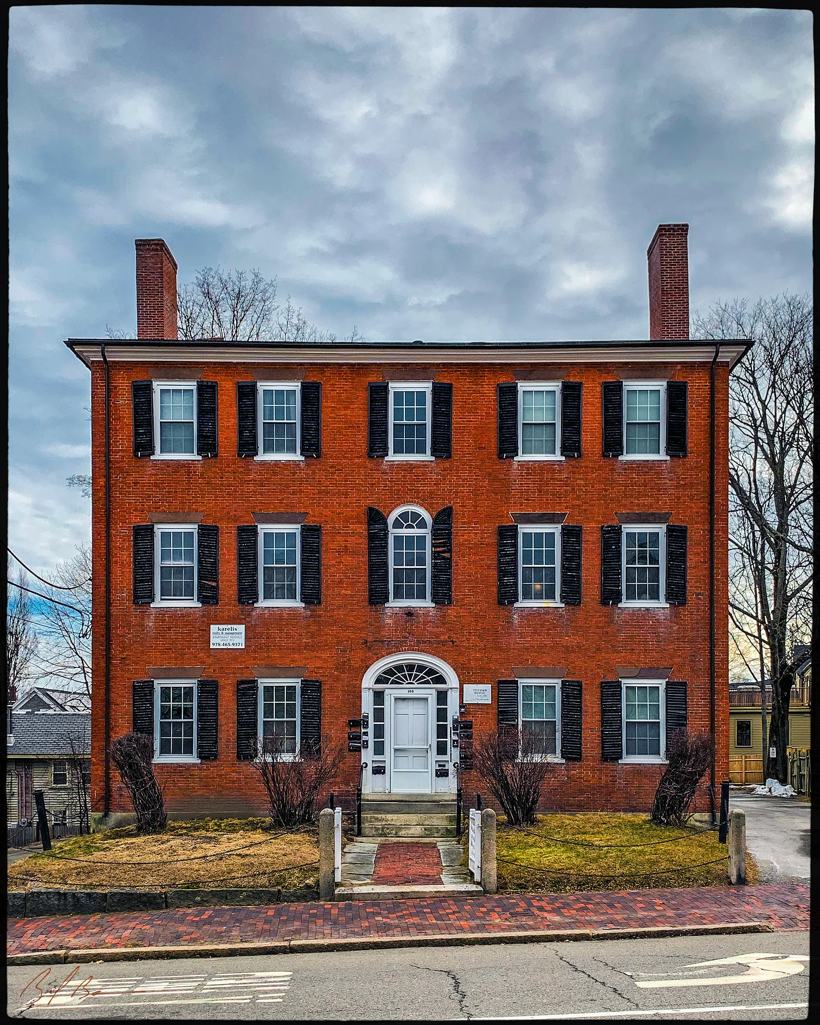
Hale's Old Newburyport Houses has this as the Titcomb-Raymond House, numbered 107 in 1912: “This land was bought by John Berry Titcomb in 1808 and the house built soon afterward, remaining in his family until 1850 when sold to George Odin.” Mrs. Curtis B. Raymond bought it from the Odin heirs in 1865. Emery, beginning her walk down the lower side of the street from High Street, starts with “the handsome brick house built by John Berry Titcomb,” and elsewhere remembers his bakery and flour store behind the North church. Currier's History of 1906 has him on the committee of 1800 that laid out the New Hill burying ground, and the second volume lists him as a selectman that year. The state inventory form, which calls it one of the best Federal houses in the town, says it was later divided into apartments.
Sources: Hale, Old Newburyport Houses (1912), p. 37 · Emery, Reminiscences of a Nonagenarian (1879), pp. 228–229 · Currier, History of Newburyport, vol. 1 (1906), p. 217 · Currier, History of Newburyport, vol. 2 (1909), p. 599 · MACRIS inventory form
Walk · 70 yardsTurn round and walk back down State Street on this side for about 70 yards. The wide two-storey house with the gambrel roof, five dormers and a rusticated front made to look like stone, on your right, is the Dalton House, number 95. look: The front is wood cut and painted to imitate blocks of stone; the sides are plain clapboard.
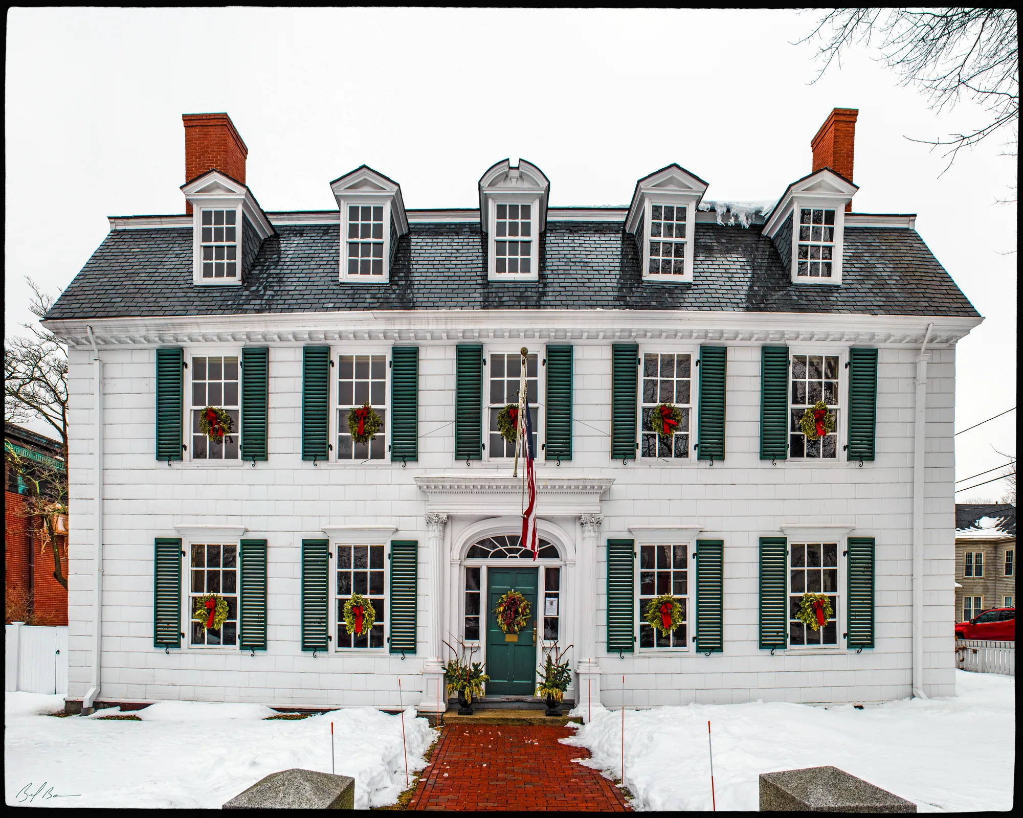
Hale says Michael Dalton bought this estate in 1746, and that although the deed mentions a house, the one standing is believed to be his. “Ould Newbury” has the deed: three acres bought of Gideon Bartlett of Amesbury for sixteen hundred pounds old tenor, bounded westerly on Greenleaf's lane or Fish Street. “On this land Michael Dalton erected a fine house, with a spacious barn and court-yard adjoining.” Dalton was a mariner turned merchant with a distillery at the foot of Market Street, and he presided as moderator at the first town meeting of Newburyport in 1764. His son Tristram, a Harvard classmate of John Adams, had the house from 1764 and, Currier says, sat in the first United States Senate, drew the short two-year term, lost his re-election, sold his real estate in 1796 to buy land in the new city of Washington, lost that too, and ended in a post in the Boston custom house, where he died in 1817.
Hale says simply: “This house is noted for the great number of its distinguished guests.” Currier says Washington left town on the Saturday morning, October 31, 1789, after an early breakfast with Tristram Dalton. Dalton conveyed the house to his son-in-law Moses Brown, in 1791 by Hale's list and 1796 by Currier's deed, and Emery remembered “the elegant Dalton establishment, then owned and occupied by Moses Brown”; Hale's list runs through Brown and the Banister heirs to 1880, several short owners, and the Dalton Club from 1897, which still has it. The state inventory form dates it about 1747 and calls it the finest Georgian house in Newburyport; it adds that the roof balustrade is gone and that the barn behind was cleared to make Garden Street.
Sources: Hale, Old Newburyport Houses (1912), p. 29 · Currier, “Ould Newbury” (1896), ch. "The Dalton House" · Currier, History of Newburyport, vol. 1 (1906) · Emery, Reminiscences of a Nonagenarian (1879), p. 229 · MACRIS inventory form
Walk · a few stepsNext door, a few steps down on your right, is the Institution for Savings, number 93, the brownstone-trimmed bank with the projecting centre and the arched windows.
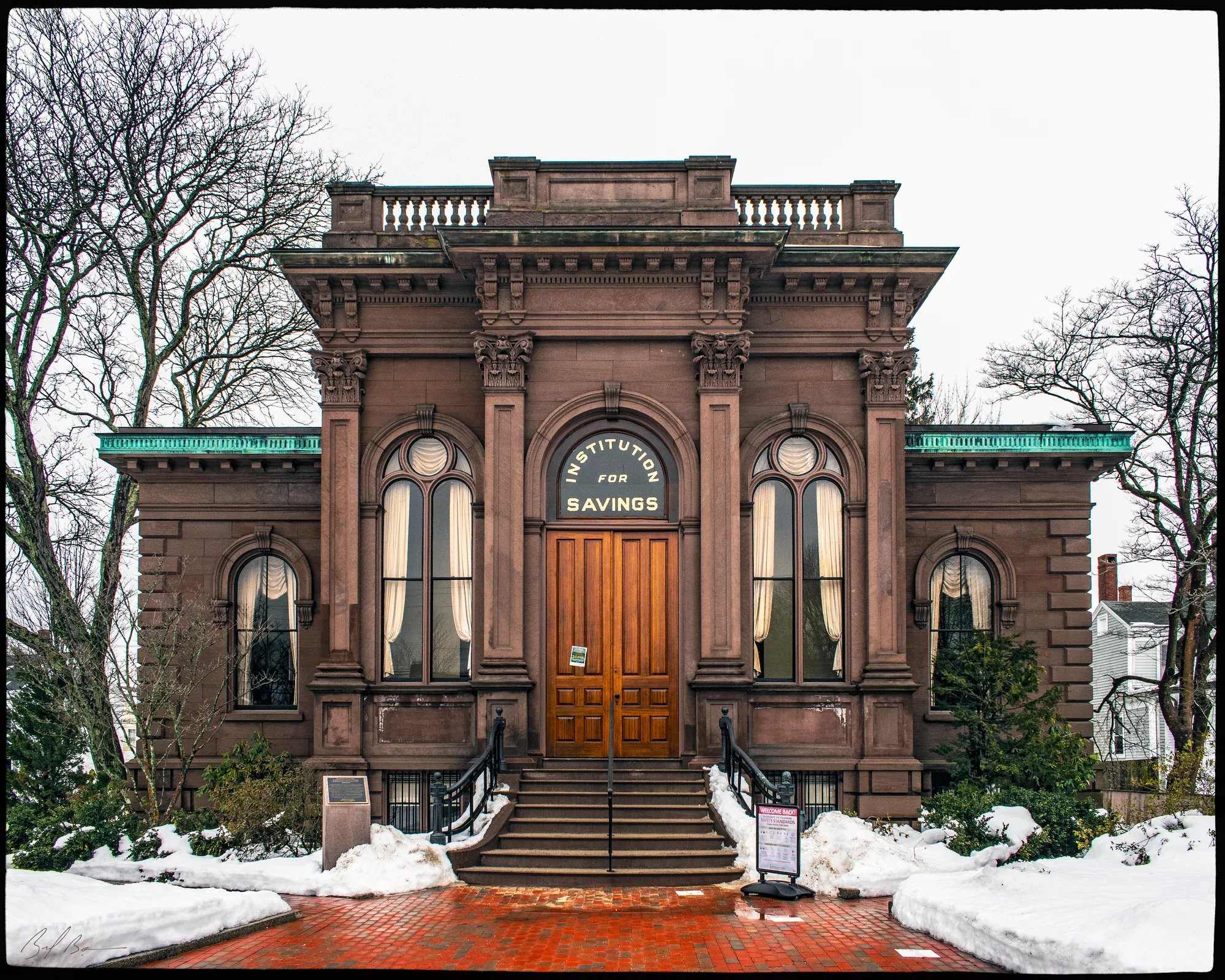
The bank is half a century older than its building, and Currier's second volume has the whole story. The Institution for Savings in Newburyport and its Vicinity was incorporated on January 31, 1820, by William Bartlet, Moses Brown, Thomas M. Clark, Joshua Carter and a score of others, and opened at noon on April 5 that year in the selectmen's room under the Town Hall at State and Essex Streets. It moved afterwards to rooms over a brick building at State and Pleasant, back to the old town hall after that was sold in 1845, and in 1856 to the Merchants Bank building at State and Charter. In the spring of 1872 it moved to “a new and commodious building, opposite Wolfe tavern, on State street,” and has been here since. The state inventory form calls it the most elaborate Italianate building in Newburyport, with its brownstone quoins and consoles and a copper balustrade along the cornice, and says it keeps its original interior.
Sources: Currier, History of Newburyport, vol. 2 (1909), pp. 170–171 · MACRIS inventory form
Walk · 150 yardsContinue down State Street on the right-hand side for about 150 yards, past the modern buildings, to the brick block just above Charter Street, numbers 63 to 69.
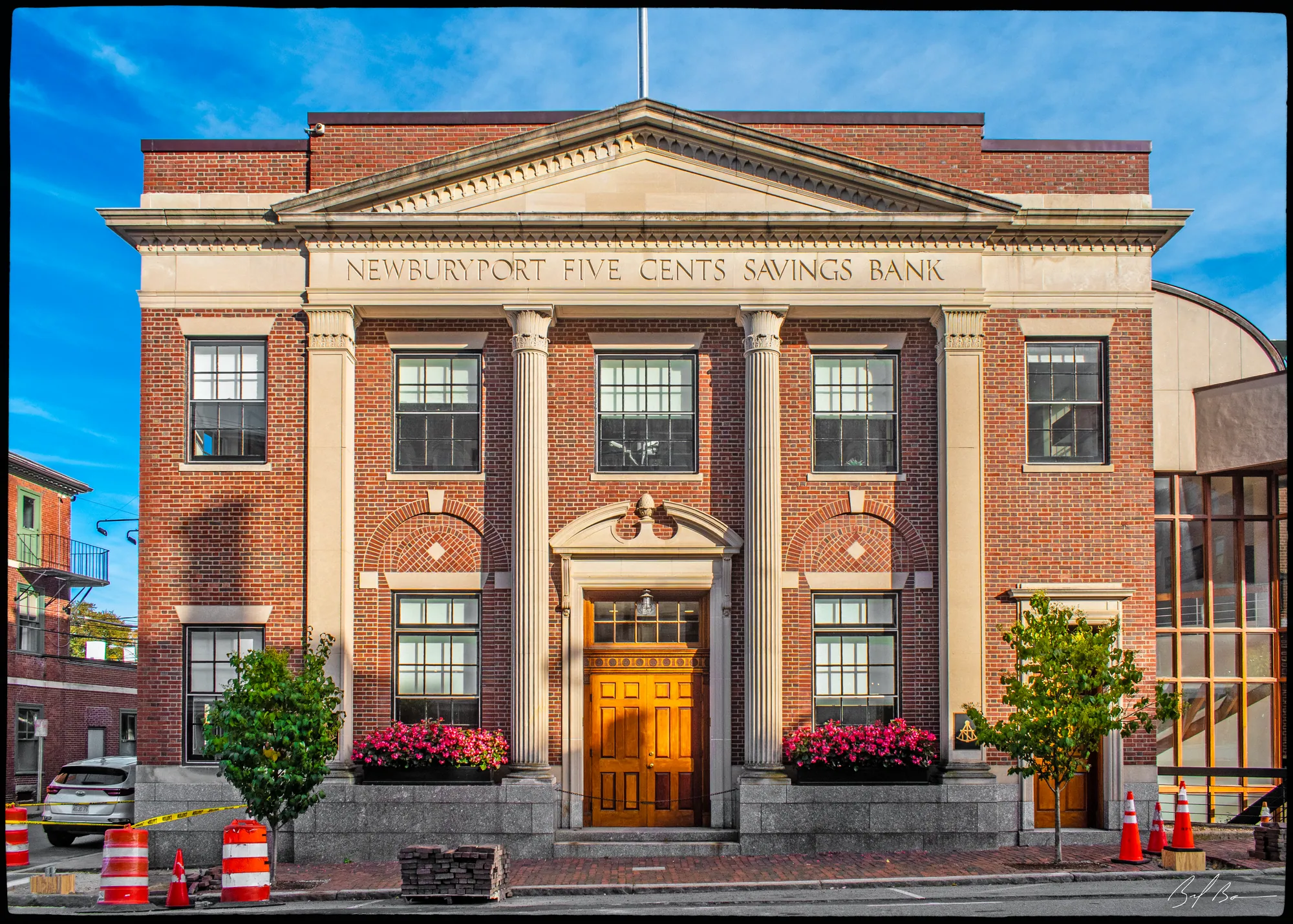
The histories were all written before this block existed, so the inventory form is all we have on it: a Colonial Revival commercial block of about 1928, a twentieth-century building dressed in the manner of the street. Emery's memory of this stretch, below Temple Street, was of Colonel Stephen Bartlett's house on the lower corner, then the Moulton house and David Wood's, and then the bank building; Currier says Prince Stetson kept the Wolfe Tavern in Colonel Bartlett's house for the three years after the fire.
Sources: MACRIS inventory form · Emery, Reminiscences of a Nonagenarian (1879), p. 229 · Currier, “Ould Newbury” (1896), ch. "Wolfe Tavern"
Walk · a few stepsCross Charter Street. The three-storey brick building on the corner, with the pedimented centre doorway and marble belt courses between the floors, is the Merchants National Bank building, numbers 59 and 61.
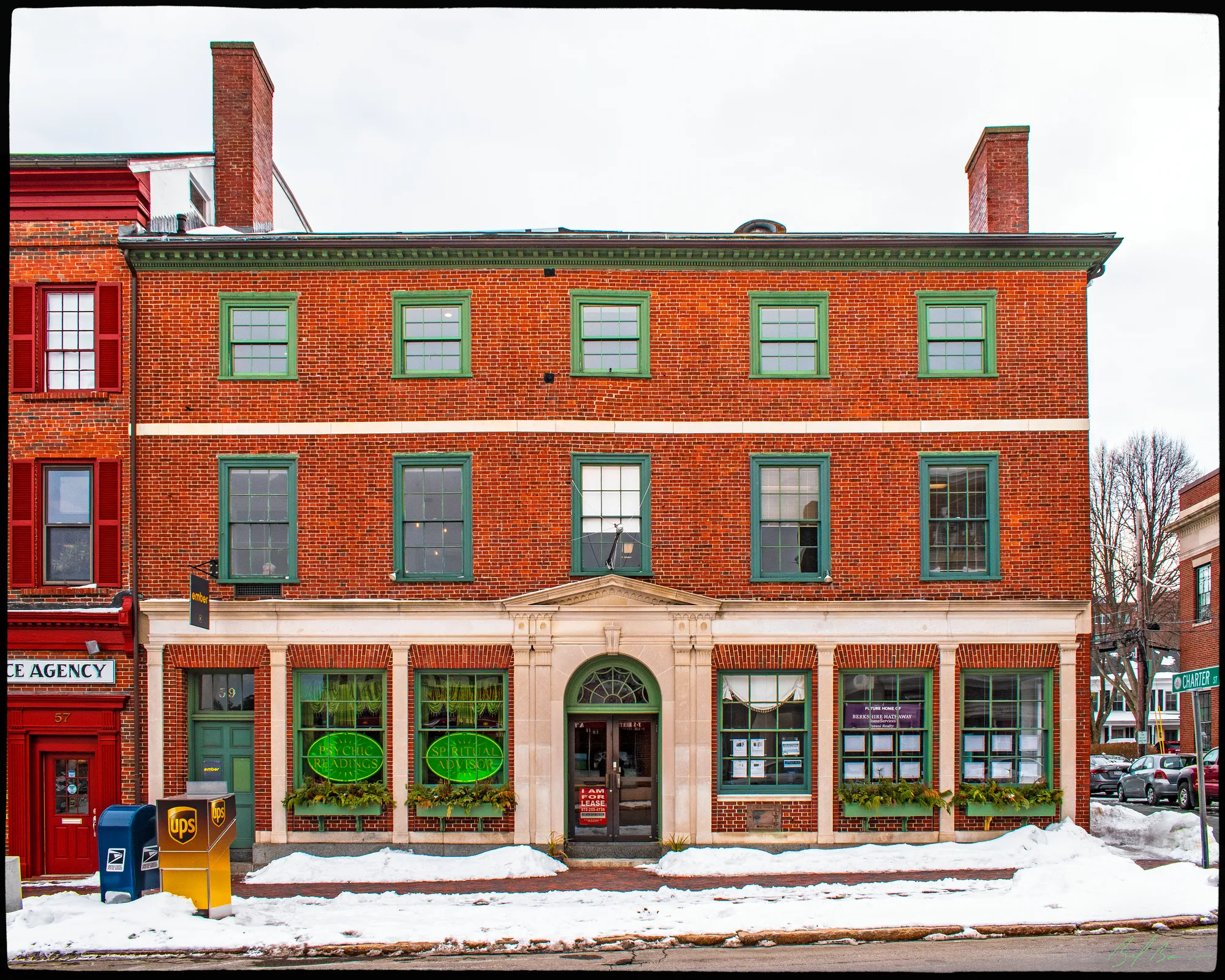
Currier's second volume says Moses Brown, the chaise maker turned merchant who later bought the Dalton House, “lived for nearly twenty years after that date in a house then standing on State street, where the Merchants Bank building now stands,” from his marriage in 1772. The state inventory form believes the present block was built about 1800, and there has been a bank in it since 1803: Currier gives March 8, 1803, as the date Micajah Sawyer, Joshua Carter and their associates were incorporated as the Newburyport Bank. Emery remembered it with William Bartlet as president and Samuel Mulliken as cashier. The Merchants Bank was incorporated in 1831 and became the Merchants National Bank in 1865.
The upper floors have had a civic life of their own. Currier says the Merrimack Library Association took rooms here in 1852 and set up a reading room, the seed of the public library two years later, and that the Odd Fellows leased the third-floor hall in June 1853 and kept it for half a century. The inventory form says the Colonial Revival front with its fanlight entrance is the bank's remodelling of 1921 by Hutchins and French of Boston.
Sources: Currier, History of Newburyport, vol. 2 (1909), pp. 126, 164, 167–168, 175, 226–227 · Emery, Reminiscences of a Nonagenarian (1879), p. 229 · MACRIS inventory form
Walk · a few stepsNext door, a few steps further down, is the Grand Army Building, number 57, three bays wide with a bronze plaque between the ground-floor windows. look: The plaque of 1924 commemorates the men who left for the Civil War in April 1861.
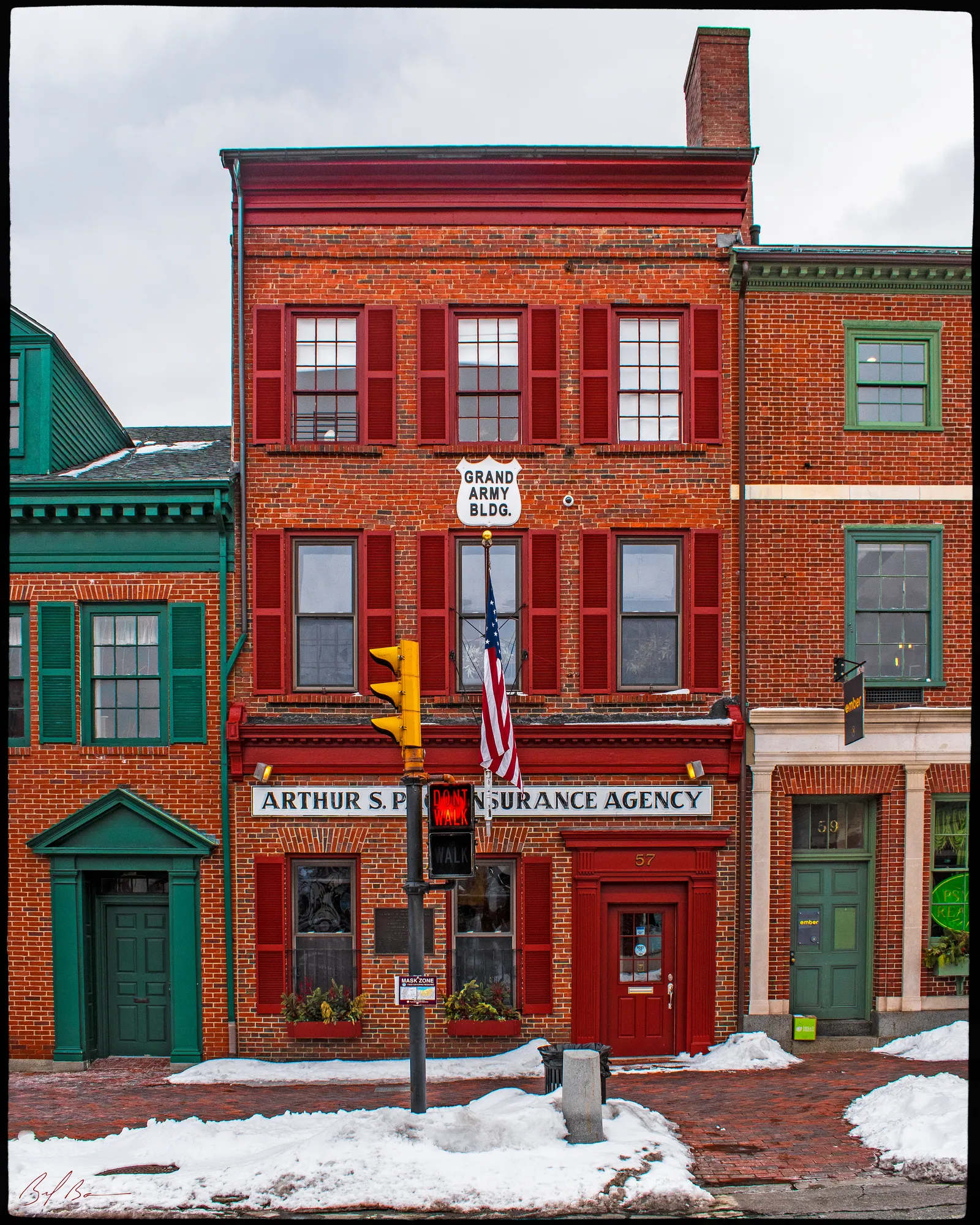
Currier's History of 1906 tells what the plaque remembers. When Lincoln called for troops after Fort Sumter, the Eighth Massachusetts was ordered to Washington, and on April 16, 1861, “while rain and sleet were falling fast, the first detachment of the Cushing Guards, consisting of twenty members of company A of the Eighth regiment, left Newburyport for Boston,” under Captain Albert W. Bartlett. Seventy more joined them at Faneuil Hall two days later. Hurd's History of Essex County says Bartlett had his orders by telegraph at half past three on the Monday afternoon and served the summons on his whole company before dark. He later commanded Company B of the Thirty-fifth, which fought at Antietam, and the Grand Army post organized in Newburyport in 1868 took his name.
The inventory form, citing the local historian Ron Irving, says the block was built in 1853 by William J. Hodge for Amos Tappan, with a hardware store below and the Cushing Guard's armory on the top floor, though whether the company actually marched from this door has not been verified. The A. W. Bartlett Post bought it as a memorial building in 1877. The plain brick front with shutters is a remodelling of 1960.
Sources: Currier, History of Newburyport, vol. 1 (1906), p. 669 · Hurd, History of Essex County, vol. 2 (1888) · MACRIS inventory form
Walk · 60 yardsContinue down State Street on the right-hand side for about 60 yards, crossing Essex Street. The Italianate brick block just below the corner is Essex Hall, numbers 35 to 41.
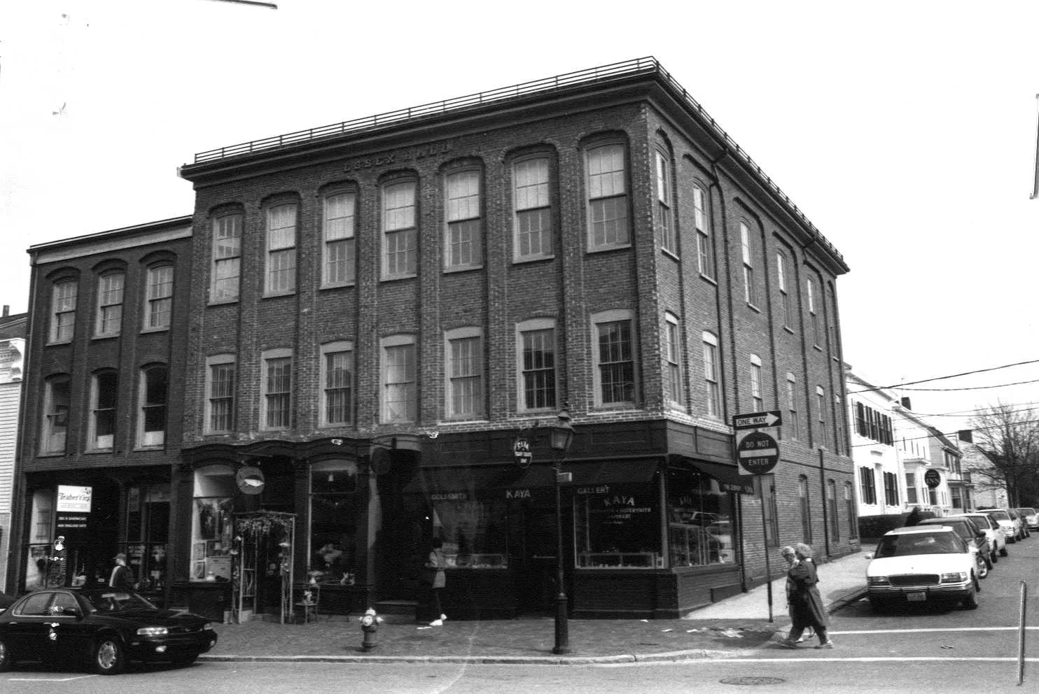
Stop 20 · c. 1855
35–41 State Street
Essex Hall
Photo: Massachusetts Historical Commission, MACRIS inventory
Currier's second volume knows this block as Essex Hall and places it on the lower corner of State and Essex Streets. The Young Men's Christian Association, founded in 1876 in the brick building across Essex Street, met for a time in rooms under Essex Hall before moving on to Pleasant Street in 1880, and the Newburyport Co-operative Bank, founded in 1888, moved into the Essex Hall building in 1904. The inventory form dates the block to about 1855. It also notes, in its account of the Grand Army Building, that Albert W. Bartlett worked in a dry-goods store at 37 State Street before the war, and Currier says that Moulton and Lunt, jewellers, were at number 45, nearly opposite Essex Street, in 1906. The Town Hall stood on the other corner of Essex until 1845; Emery says General John Peabody built it in 1809 in exchange for the old town house lot, with the names of the states painted above the windows of the hall.
Sources: Currier, History of Newburyport, vol. 2 (1909), pp. 145, 172 · Currier, History of Newburyport, vol. 1 (1906), p. 171 · Emery, Reminiscences of a Nonagenarian (1879), p. 230 · MACRIS inventory form
Walk · a few stepsWalk back up to the corner of Essex Street and turn left into it; go a few steps along Essex Street and stop. Joseph Moulton's shop was in the brick building on this corner of State and Essex.
Stop 21 · Lost
Joseph Moulton’s silversmith shop
The Moultons made silver in Newbury and Newburyport for two hundred years. Currier's History of 1906 begins with William Moulton, a silversmith here as early as 1690, and follows the trade down through a Joseph with a shop on Fish Street, a William who left for Marietta, Ohio, in 1788, and a Joseph born in 1744 whose shop was on the lower side of State Street between Charter and Temple. The Joseph Moulton this stop remembers, born February 17, 1814, fifth in descent from the first William, in 1845 “had a shop on Merrimack street, near Market square, where he made and sold gold beads and silver ware,” and afterwards moved to the brick building on this corner. His son William carried on as Moulton and Lunt at 45 State Street.
Currier also records the firm that grew out of this trade: Anthony F. Towle and William P. Jones began making silverware as Towle and Jones in 1857 behind 8 Merrimac Street, and grew into the Towle Manufacturing Company of 1880. Our own research for this site has both Towle and Jones learning the trade in Moulton's shop.
Sources: Currier, History of Newburyport, vol. 1 (1906), pp. 169–173 · oldnbpt.com research
Walk · 90 yardsReturn to State Street and turn right, downhill, for about 60 yards on the right-hand side. The three-storey brick block with the newsstand on the ground floor is Fowle's, numbers 17 to 21.
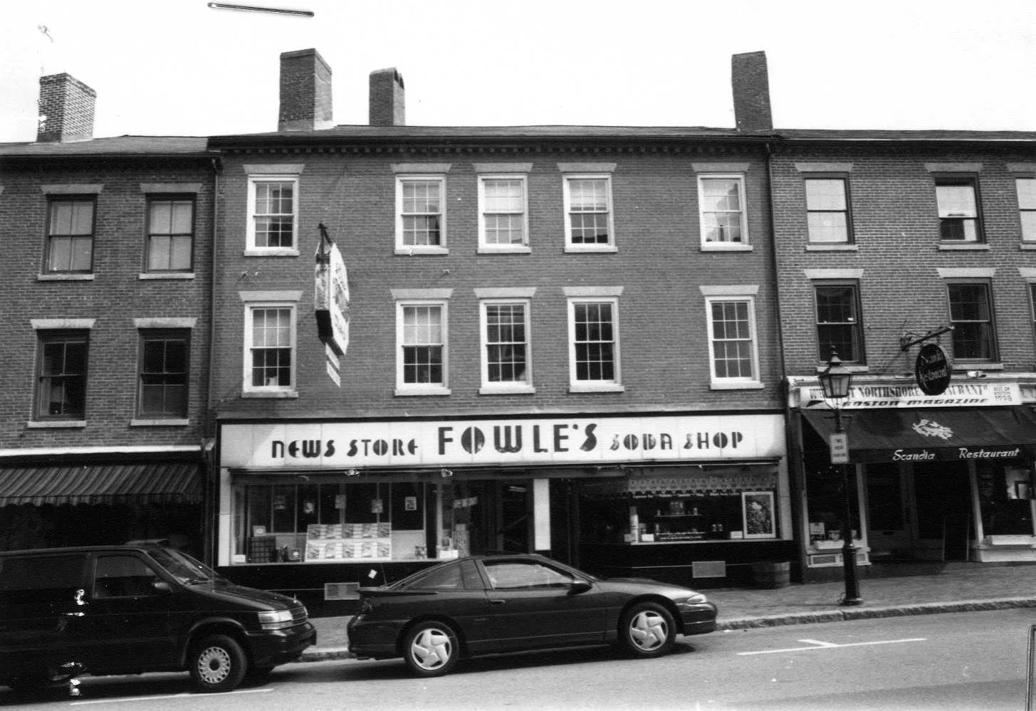
Stop 22 · c. 1820
17–21 State Street
Fowle's News
Photo: Massachusetts Historical Commission, MACRIS inventory
The inventory form is all we have on this one: a Federal commercial block of about 1820, part of the brick rebuilding of the lower street, which the site knows as Fowle's News. Somewhere in this stretch below Essex Street stood the old Clement house of Emery's childhood, where a man walked a tightrope across State Street from one of its chimneys to a chimney of the Wolfe Tavern opposite, an event that made no little sensation in the staid town.
Sources: MACRIS inventory form · Emery, Reminiscences of a Nonagenarian (1879), p. 230
Walk · a few stepsContinue down State Street a few steps to the corner of Middle Street and turn right into Middle Street; stop just round the corner. The angled brick block on the corner, numbered 1 to 5 State Street on one face and 1 Middle Street on the other, is the Central Labor Union Hall.
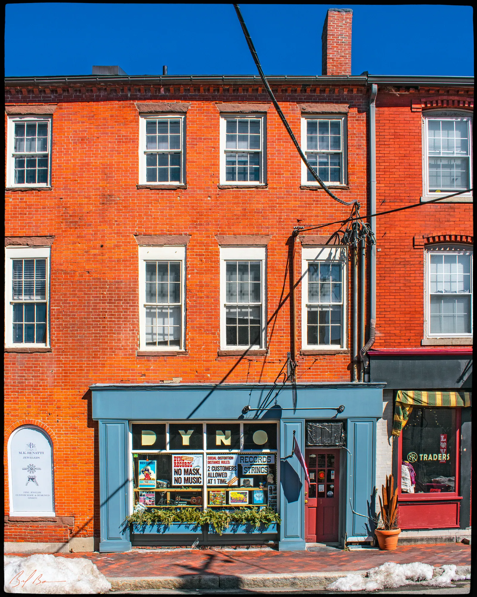
The inventory form believes this block was built soon after the fire, and dates it about 1820. Currier's second volume may fix it more closely: John Porter, the insurance broker who had an office at No. 14 Cornhill in 1815, in 1825 “removed to the brick building, which was then just completed, on the corner of Middle and State streets.” Currier's first volume has the Christian Herald, a Freewill Baptist newspaper, published weekly at this corner in 1847 with the Reverend Daniel P. Pike as editor.
The inventory form says a pharmacy was kept at 1 State Street by Daniel Smith early in the century, called in 1890 the oldest store in Newburyport, and that Edward W. Eaton opened Eaton's Drug Store here in 1900 before moving it up to the Pleasant Street corner in 1922. Emery knew Dr. Smith, forty years an apothecary, with his store on Market Square, and called him “one of the most upright and genial of men, possessing great intelligence and force of character.” The upstairs hall gave the building its name: the Order of United American Mechanics met here from about 1905, and later the Knights of Pythias and the Hellenic American Club.
Sources: Currier, History of Newburyport, vol. 2 (1909) · Currier, History of Newburyport, vol. 1 (1906), p. 514 · Emery, Reminiscences of a Nonagenarian (1879) · MACRIS inventory form
Back to the start · 140 yardsGo back to State Street, turn right and walk the last 50 yards down to Market Square, where you began; about 150 yards in all.
You have walked the whole length of the fire. Currier says the Davenports built back in brick on the tavern corner while some lots on the square stayed empty for ten or fifteen years, and Mrs. Smith's history of 1854 says the town's spirit of enterprise did not recover for twenty years after; but the street you have just walked, from the Firehouse to the Dalton House, is the result.
Sources for this walk
The script paraphrases and quotes these works, all of them out of copyright, and names each one as it goes. Page numbers are from the editions linked here. Where the script says “our research for this site,” the facts are from the building page it links to.
- John J. Currier, History of Newburyport, Mass., 1764–1905, vol. 1 (Newburyport: the author, 1906). archive.org/details/historyofnewbury01curr
- John J. Currier, History of Newburyport, Mass., 1764–1905, vol. 2 (Newburyport: the author, 1909). archive.org/details/historyofnewbury04curr
- John J. Currier, “Ould Newbury”: Historical and Biographical Sketches (Boston: Damrell & Upham, 1896). archive.org/details/ouldnewburyhisto00curr
- Joshua Coffin, A Sketch of the History of Newbury, Newburyport, and West Newbury, from 1635 to 1845 (Boston: Samuel G. Drake, 1845). archive.org/details/sketchofhistoryo00coff_0
- E. Vale Smith, History of Newburyport; from the Earliest Settlement of the Country to the Present Time (Newburyport, 1854). archive.org/details/historyofnewbury00blake
- Sarah Anna Emery, Reminiscences of a Nonagenarian (Newburyport: William H. Huse, 1879). archive.org/details/reminiscencesofn00emer
- Caleb Cushing, The History and Present State of the Town of Newburyport (Newburyport: E. W. Allen, 1826). archive.org/details/historypresentst00cush
- William H. Bayley and Oliver O. Jones, History of the Marine Society of Newburyport, Massachusetts, from Its Incorporation in 1772 to the Year 1906 (Newburyport, 1906). archive.org/details/historyofmarines00baylrich
- Albert Hale, comp., Old Newburyport Houses (Boston: W. B. Clarke Co., 1912). archive.org/details/cu31924015356714
- D. Hamilton Hurd, comp., History of Essex County, Massachusetts, vol. 2 (Philadelphia: J. W. Lewis & Co., 1888). archive.org/details/historyofessexco02hurd
- Massachusetts Historical Commission, Massachusetts Cultural Resource Information System (MACRIS), Newburyport inventory forms. mhc-macris.net
- Biff Bouse, oldnbpt.com building pages (own research from deeds, Sanborn maps and newspapers). oldnbpt.com
More walks: Green Street, Brown Square and Pleasant Street · High Street: Down Along and the Ridge · Federal, Spring and Middle Streets · The Water Street Waterfront · Joppa: The Oldest Houses · Joppa: The Fishing Village · Along the River: The North End Shipyards · The Rail Trail: Mills, Ropewalks and Old Hill · Newburyport in the Civil War · Churchyards and Burying Grounds