Walking tours · Waterfront · 9 stops
Along the River: The North End Shipyards
A level loop up Merrimac Street from Cashman Park to the foot of Ashland Street and back, past the old Towle silver factory and the sites of the shipyards where Newburyport's clipper ships, Civil War gunboats and the last square-rigger built in Massachusetts went down the ways. Nothing of the yards is left but the street names and the river; the walk is about a mile and a half.
- Length
- About 1.5 mi, a loop
- Time
- About 55 min, with the reading
- Start and finish
- Cashman Park, Merrimac Street
Before you set off
This stretch of riverbank was the town of Newbury, not Newburyport, until 1851. John J. Currier's History of Newburyport, published in 1906, says the line between the two ran along North Street, now Oakland Street, and that when the land above it was annexed in 1851 the shipyards came with it; before then, he says, “many famous merchant and clipper ships were built in the yards above North street.” Sarah Anna Emery, who was born in 1787 and wrote her Reminiscences of a Nonagenarian at ninety, remembered that “Ship yards were scattered along the river bank from Pierce's farm to Moggaridge's point,” and that in the summer of 1766 seventy-two vessels were on the stocks at once. Mrs. E. Vale Smith, whose History of Newburyport came out in 1854 while the yards were still at work, walked this very road in her book: beyond the railroad bridge the first yard she came to was Manson and Fernald's, then a tannery, then the blacksmith shops that served the bigger yards, and “Here we shall probably see several clippers on the stocks in various degrees of progress, and perhaps a steamboat building.”
Currier gives the ending too. The ship Mary L. Cushing, launched from John Currier Jr.'s yard in April 1883, “was the last square-rigged vessel built in the state of Massachusetts,” and after that the business, in the words of his “Ould Newbury” of 1896, was “now practically extinct on the Merrimack River.” What you walk past today is the shore where it happened.
Numbers follow the walk. The line is the route along the streets, back to where you started.
Read it aloud as you go: each stop begins with where to walk and where to stand, then what the old histories say about the place. The sources are named as you read and listed in full at the end.
StartThe loop begins at Cashman Park, the riverside park on Merrimac Street below Oakland Street, where the Clipper City Rail Trail meets the river. Park here if you are driving. Walk down to the Harborwalk at the water's edge and stand facing the river, with the city behind you and the open water running away upstream to your left.
Stop 1
Cashman Park
The state's historic inventory lists this park, and the city named it in 1944 for Mayor Michael Cashman; it is now the gateway to the rail trail that follows the old railroad line out of town. The river in front of you is the reason for the walk. Emery says the first ferry across the Merrimack was at Carr's Island, upstream and to your left, and that the first building yards were there. Currier's 1906 History records that in 1810 alone twenty-one ships, thirteen brigs and a schooner were built on this river, and he quotes a newspaper of May 1820, when more than forty vessels, held in port for a week by easterly winds, sailed together at noon: “We believe our river never was whitened with so much canvas at one time as was spread yesterday noon; it was a delightful sight.” The yards that built them lay along the bank you are about to walk, from here to Ashland Street.
Sources: MACRIS inventory form · Emery, Reminiscences of a Nonagenarian (1879), p. 225 · Currier, History of Newburyport, vol. 1 (1906), p. 453
Walk · 380 yardsTurn left and follow the Harborwalk upstream with the river on your right for about 70 yards, then turn right onto the path that leads up to Merrimac Street, about 180 yards. Carry straight on along Merrimac Street for about 125 yards. The long four-storey brick factory on your right, at the foot of Broad Street, is 260 Merrimac Street, the Towle Building. Stop opposite the tall stair tower in the middle of its front. look: The stair tower with its own small mansard roof is the one piece of the 1866 roofline left; the inventory form says the rest of the mansard came off between 1905 and 1910.
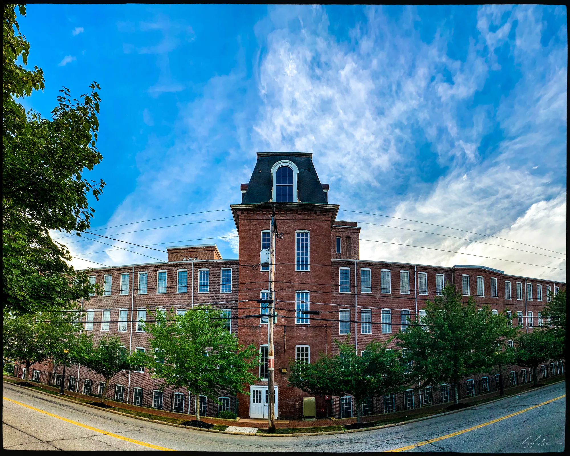
This was a gun factory before it was a silver factory. Currier's History of 1906 says the brick building at the foot of Broad Street was “erected in 1866 by the Merrimack Arms and Manufacturing Company,” and the state inventory form adds that by 1872 it belonged to the Brown Manufacturing Company. Currier traces the silversmiths from 1857, when Anthony F. Towle and William P. Jones, as Towle & Jones, began making silver ware behind No. 8 Merrimac Street; they moved to Middle Street, took in Edward B. Towle in 1870, and parted in 1873. The Towle Manufacturing Company, organized in 1880, bought this building in 1883 and, Currier says, had occupied it ever since; by 1906 its capital stock stood at three hundred and seventy-two thousand dollars. The inventory form says the firm employed more than three hundred people here in its best years and was known across the country for sterling flatware. The form also walks through the additions: a brick water tower on the river side by 1906, a north wing of about 1926, a south wing dated 1947 by a stone block in its foundation, and the glass-and-metal entrance on the river side of about 2010. Towle renamed itself Merrimac Corporation in 1990 and the plant was sold in 1997 and turned into offices.
Sources: Currier, History of Newburyport, vol. 1 (1906), p. 173 · MACRIS inventory form
Walk · 100 yardsWalk back the way you came, downstream along Merrimac Street, about 70 yards, and turn left into Sally Snyder Way, the short street on the river side of the Towle Building. Stop after about 25 yards, where you can see the river across from the foot of Broad Street.
Stop 3 · 1863 · Lost
Brush Factory
The histories have little for this one, so it is our own research for this site that places a brush factory of 1863 here on the river side, across from the foot of Broad Street, and says it later made toothbrushes. Hurd's History of Essex County, published in 1888, does list a Harvard Brush Company among the city's employers of the 1880s, alongside the Towle companies, a water company, a quarry company and a towing company, as the kind of industry that had taken the place of shipbuilding; whether that was the firm working on this spot the book does not say. Look across the river from here, though, because this is the view the shipwrights had: the channel, Carr's Island upstream, and the Salisbury shore.
Sources: oldnbpt.com research · Hurd, History of Essex County, vol. 2 (1888)
Walk · 210 yardsReturn to Merrimac Street and turn right, upstream. Walk about 190 yards. Where Oakland Street comes down from your left, the North End Boat Club on the river side is the site of Eben Manson's yard.
Stop 4 · 1852 · Lost
Manson Shipyard
Oakland Street was North Street, and Currier's History of 1906 says it was the northern boundary of Newburyport from 1764 until 1851; the city renamed it in 1852. Mrs. Smith, walking this way in 1854, says “The first ship-yard we approach, is that of Messrs. Manson & Fernald,” and Currier's 1896 “Ould Newbury” puts it plainly: “At the foot of Oakland Street Eben Manson built many ships and barks from the year 1853 to 1873.” His list in the 1906 History begins a year earlier, with the schooners Amelia and Golden West in 1852, and runs through barks and ships to a pair of schooners built for a Haverhill owner in 1874; the barks Sam Slick and Golden Rule and the schooners Flying Cloud and Helen Young were built in partnership with William Fernald. Our research for this site remembers the yard for its fast schooners, and one of them has a war story. Currier says the schooner Enchantress, 160 tons, built here by Manson, was taken by the Confederate cruiser Jeff Davis on July 6, 1861, and recaptured off Charleston by the U.S.S. Albatross before the month was out; her Newburyport owners were later paid three thousand dollars for the loss. Currier adds that A. F. Towle & Son put up a silver-plate factory at the foot of this street in 1882 and moved the machinery to Greenfield in 1890.
Sources: Currier, History of Newburyport, vol. 1 (1906), pp. 173, 235, 347, 466–467 · Currier, “Ould Newbury” (1896), ch. "Old Ship-Yards" · Smith, History of Newburyport (1854), p. 270 · oldnbpt.com research
Walk · 420 yardsCarry on up Merrimac Street, keeping the river on your right, for about a quarter of a mile. Stop at the foot of Butler Street, by Merrimack Court, the narrow lane that runs down toward the river. The land between here and the water was John Currier Jr.'s yard.
Stop 5 · 1831 · Lost
John Currier Jr. Shipyard
Merrimack Court was Poore's Lane, and Currier's “Ould Newbury” of 1896 says the way down it was the road to Carr's ferry as early as 1641. The sketch of this yard in that book is a son's: the historian John J. Currier was the shipbuilder's only surviving child, and Hurd's History of Essex County of 1888 says he kept his father's accounts and bought his materials for thirty years. “Ould Newbury” says John Currier Jr. began as a master builder in 1831 in the Merrill yard just upstream, bought about five acres on Poore's Lane from Ebenezer Savory on May 28, 1833, and moved here the next year. “During his long and active life he built nearly one hundred large vessels, with a total registered capacity of more than 90,000 tons.” Hurd counts them: ninety-seven vessels between 1831 and 1884, ninety-two of them ships, and in one busy year in the mid-1850s six ships averaging eight hundred tons. Mrs. Smith adds that a steam mill was put up in the yard in 1847 to saw the timber, and the second volume of Currier's History says the river steamer Merrimac was built here in 1850.
The 1906 History gives the yard's one literary moment. The ship Whittier, launched on January 14, 1869, was named for the Quaker poet, who sent his regrets: “I hope the Merrimack will give her a kindly welcome to her proper element.” Two of the yard's ships, the Star of Peace and the Charles Hill, were burned by Confederate cruisers in 1863. The last was the Mary L. Cushing of 1883, which Currier calls the last square-rigged vessel built in Massachusetts; the builder died on September 2, 1887. Our research for this site places the yard at the foot of Butler Street; Currier's own books call it the yard on Merrimack Court.
Sources: Currier, “Ould Newbury” (1896), ch. "Old Ship-Yards" · Hurd, History of Essex County, vol. 2 (1888) · Smith, History of Newburyport (1854), p. 264 · Currier, History of Newburyport, vol. 1 (1906), pp. 235, 456–459 · Currier, History of Newburyport, vol. 2 (1909), p. 72 · oldnbpt.com research
Walk · 170 yardsContinue up Merrimac Street about 170 yards and turn right into Union Place, the short street on the river side between Butler and Forrester Streets. Stop at its mouth. The rocky point beyond is Moggridge Point, and the shore here held the oldest yard on the walk.
Stop 6 · Lost
Moggridge Point and the Merrill Shipyard
Emery says that “as early as 1730, Mr. Samuel Moggaridge had a dwelling house and building yard at the rocky point farther up the river, afterwards known as Moggaridge's point.” Currier's History of Newbury of 1902 goes back further: in 1641 travellers for Salisbury came down Poore's Lane to this point of rocks and found boatmen to row them across. He prints Moggaridge's contract of November 30, 1741, to build a vessel for Witter Cummings and Benjamin Harris, paid partly in cash and partly in flour, loaf sugar, a bag of cotton wool, a hogshead of rum and a hundredweight of cheese, and says that for more than twenty years Moggaridge was a prominent builder, a man with farms in three towns who also owned slaves. Hurd's History of Essex County says the “Jew's Rafts,” timber lashed into the shape of a ship and sailed to England for a Mr. Levi, were built in this yard; one reached London in 1770.
“Ould Newbury” names the men who followed: Jonathan Merrill, Nathan Merrill and Orlando B. Merrill, and after them the Jackmans. Currier's History of Newbury says the Merrills bought land near the point in 1798, and Mrs. Smith credits Orlando B. Merrill with more than sixty vessels, among them the ship Pickering in 1798 and, with William Cross, the sloop-of-war Wasp in 1813. The 1902 History also puts Donald McKay here before he was famous: employed by John Currier Jr. to superintend the ship Huntress in 1839, he and William Pickett built the St. George, 845 tons, in the Moggaridge yard in 1843, and the John R. Skiddy and Joshua Bates the next year, before he left for East Boston in 1845. He is buried in Oak Hill Cemetery here.
Sources: Emery, Reminiscences of a Nonagenarian (1879), p. 225 · Currier, History of Newbury (1902), pp. 437, 483–485, 491 · Hurd, History of Essex County, vol. 2 (1888) · Currier, “Ould Newbury” (1896), ch. "Old Ship-Yards" · Smith, History of Newburyport (1854), p. 261 · Currier, History of Newburyport, vol. 1 (1906), p. 453
Walk · 170 yardsGo back to Merrimac Street and turn right. Walk about 165 yards to the foot of Forrester Street, which comes down from your left. The river side here, at the point and just below it, was the Jackman yard.
Stop 7 · Lost
Jackman Shipyard
Forrester Street is younger than the yard; Currier's History of 1906 says the city laid it out from High Street to the river in 1859. Currier's History of Newbury says Stephen Jackman Jr. built twenty-five or thirty vessels between 1830 and 1848 in the yard next to the Moggaridge place, including thirteen brigs for Captain John N. Cushing and two coastal steamers, the Decatur and the Ohio. On December 6, 1849, his brother George W. Jackman Jr. bought “the Moggaridge estate” from Mary W. and Eleanor Moggaridge, the builder's descendants, who, Mrs. Smith says in 1854, still lived on the spot and lent her the 1741 contract. He took over Stephen's yard too, and launched his first vessel, the bark Hollander, in 1850; Smith lists the ship Whistler of 900 tons from his yard in 1853.
The 1906 History tells the rest. “During the Civil war the gunboat Marblehead, 529 tons register, and the steamer Ascutney, 1040 tons register, were built by George W. Jackman, Jr., for the United States government,” and in 1866 and 1867 he built the steamships Ontario and Erie, three thousand tons each, for a company of Boston merchants; our research for this site counts them the two largest wooden steamships built in Massachusetts. Currier's list of the yard ends with the ship Landseer in 1874. Jackman was the city's wartime mayor, serving in 1862, 1864 and 1865 according to the roll in the second volume of Currier's History, and again in 1877; Currier records him presiding at the memorial service for Lincoln in April 1865, and at the dinner for the returned soldiers that July.
Sources: Currier, History of Newburyport, vol. 1 (1906), pp. 348, 423, 439, 457–459, 465–466 · Currier, History of Newbury (1902), pp. 491–492 · Smith, History of Newburyport (1854), pp. 72, 265 · Currier, History of Newburyport, vol. 2 (1909), p. 606 · oldnbpt.com research
Walk · a few stepsContinue up Merrimac Street about 50 yards to the foot of Ashland Street. The river side here was the Currier and Townsend yard, where the Dreadnought was built.
Stop 8 · 1843 · Lost
Currier and Townsend Shipyard
Ashland Street was Pilsbury's Lane, a drift way to the river that Currier's History of 1906 traces to 1735, renamed in 1852. His “Ould Newbury” says Elisha Briggs came from Pembroke in 1807 and set up as a shipbuilder here, and that the yard was afterwards enlarged and taken by William Currier and James L. Townsend, “who built there many famous clipper ships.” The History of Newbury says William Currier worked with Briggs before 1840 and with Donald McKay in 1842, and that Currier & Townsend's first vessels in this yard were the bark Talisman in 1843 and the ship St. Patrick in 1844. Mrs. Smith, counting in 1854, gives the firm twenty-three ships, two brigs, eight barques, a schooner and a steamboat in ten years, and prints the entry for the famous one: “Ship Dreadnaught, 1,400 tons, by Currier & Townsend, for D. Ogden and others, New York.”
Currier's 1906 History gives her the longest notice of any ship in the book. She was built for Governor E. D. Morgan, Francis B. Cutting, David Ogden and others of New York under the eye of Captain Samuel Samuels, who commanded her for nearly ten years; launched here on October 6, 1853, she left on November 3 for New York behind the tug Leviathan and spent her life as a Liverpool packet. “She was never passed in anything over a four-knot breeze.” Sailors called her the Wild Boat of the Atlantic, and in 1860 she ran from Sandy Hook to Queenstown in nine days and thirteen hours. Albert Hale's Old Newburyport Houses of 1912 gives her a plate of her own and says she was two hundred and ten feet long. Currier prints the sailors' song about her and her end: wrecked near Tierra del Fuego on July 4, 1869.
The firm, Currier says, was dissolved in 1856 through financial embarrassment; Townsend launched one more ship here, the Victory of 1857, and went to East Boston in 1865. Charles H. Currier & Co. and then George E. Currier kept the yard going, Hurd's History says, with schooners and barks into the 1880s, and Currier's list carries George E. Currier's last schooner to 1891.
Sources: Currier, History of Newburyport, vol. 1 (1906), pp. 348, 454–456, 459–460, 467–468 · Currier, “Ould Newbury” (1896), ch. "Old Ship-Yards" · Currier, History of Newbury (1902), pp. 491–492 · Smith, History of Newburyport (1854), pp. 264–265 · Hale, Old Newburyport Houses (1912), p. 67 · Hurd, History of Essex County, vol. 2 (1888)
Walk · a few stepsWalk on a few steps, about 50 yards, past the foot of Ashland Street, and stop where you can look back over the river side of the last two stops.
Stop 9 · 1863 · Lost
Bayley Hat Factory
Shipbuilding here had a second life as a hat factory. Our research for this site puts the Bayley Hat Company in the old Currier and Townsend workshop near the foot of Ashland Street from 1863, and says the mill stood until 1959. Hurd's History of Essex County, published while it was running, lists the company among the industries that had replaced the yards: incorporated in 1863 with seventy-five thousand dollars of capital, Benjamin Hale president, and a daily output of “one hundred and fifty dozen fur and wool hats,” worth a quarter of a million dollars a year. The treasurer, Hurd says, was John James Currier, the shipbuilder's son whose histories this walk has been quoting; Hurd's roll of mayors has him in office in 1879 and 1880 and Benjamin Hale in 1882. The shipwrights' sons, in other words, were running the hat mill. Nothing of it is left on the ground; the inventory of the city has no form for it, and the site's page is built from our own research.
Sources: oldnbpt.com research · Hurd, History of Essex County, vol. 2 (1888)
Back to the start · 0.6 miTurn round and walk back down Merrimac Street the way you came, with the river now on your left, for about half a mile, past Forrester, Butler, Oakland and Broad Streets. Just past the Towle Building, bear left onto the path that drops down toward the river, and at the bottom turn left onto the Harborwalk; Cashman Park is about 70 yards ahead, about six tenths of a mile in all.
On the way back, look at the river rather than the road. Emery says that in 1766 seventy-two vessels were building between Pierce's farm and Moggaridge's Point, and Currier's History of Newbury says that by 1799 yards “occupied almost every available site” along this bank and were often overcrowded with work. The last of them went quiet in the 1880s, and the parks, boat clubs and houses along the shore are what came after.
Sources for this walk
The script paraphrases and quotes these works, all of them out of copyright, and names each one as it goes. Page numbers are from the editions linked here. Where the script says “our research for this site,” the facts are from the building page it links to.
- John J. Currier, History of Newburyport, Mass., 1764–1905, vol. 1 (Newburyport: the author, 1906). archive.org/details/historyofnewbury01curr
- John J. Currier, History of Newburyport, Mass., 1764–1905, vol. 2 (Newburyport: the author, 1909). archive.org/details/historyofnewbury04curr
- John J. Currier, “Ould Newbury”: Historical and Biographical Sketches (Boston: Damrell & Upham, 1896). archive.org/details/ouldnewburyhisto00curr
- John J. Currier, History of Newbury, Mass., 1635–1902 (Boston: Damrell & Upham, 1902). archive.org/details/historyofnewbury1902curr
- E. Vale Smith, History of Newburyport; from the Earliest Settlement of the Country to the Present Time (Newburyport, 1854). archive.org/details/historyofnewbury00blake
- Sarah Anna Emery, Reminiscences of a Nonagenarian (Newburyport: William H. Huse, 1879). archive.org/details/reminiscencesofn00emer
- Albert Hale, comp., Old Newburyport Houses (Boston: W. B. Clarke Co., 1912). archive.org/details/cu31924015356714
- D. Hamilton Hurd, comp., History of Essex County, Massachusetts, vol. 2 (Philadelphia: J. W. Lewis & Co., 1888). archive.org/details/historyofessexco02hurd
- Massachusetts Historical Commission, Massachusetts Cultural Resource Information System (MACRIS), Newburyport inventory forms. mhc-macris.net
- Biff Bouse, oldnbpt.com building pages (own research from deeds, Sanborn maps and newspapers). oldnbpt.com
More walks: State Street and Market Square · Green Street, Brown Square and Pleasant Street · High Street: Down Along and the Ridge · Federal, Spring and Middle Streets · The Water Street Waterfront · Joppa: The Oldest Houses · Joppa: The Fishing Village · The Rail Trail: Mills, Ropewalks and Old Hill · Newburyport in the Civil War · Churchyards and Burying Grounds