Walking tours · South End · 10 stops
Joppa: The Fishing Village
A level loop through the South End below Bromfield Street, the part of town the histories call Joppa: along Water Street past the old landings, a shipyard that built only schooners, and the point where the clam shacks stood, then back through the streets behind, past the Methodist meeting house of 1825, the South End's own library, and the sites of a comb factory and the long ropewalks. About a mile and a half; nothing is steep.
- Length
- About 1.4 mi, a loop
- Time
- About 55 min, with the reading
- Start and finish
- Hale Flake Yard, Water Street
Before you set off
This was Newbury, not Newburyport, until 1851. John J. Currier's History of Newbury, published in 1902, says that when Newburyport was set off in 1764 the line was drawn at Cottle's Lane, now Bromfield Street, and that along the river below it, between Rolfe's Lane, now Ocean Avenue, and Cottle's Lane, “the inhabitants of Newbury were mainly occupied in catching and curing fish, and that part of the town was called Joppa, and is still known by that name.” Nobody is sure where the name came from. Horace Hovey, in his 1906 discourse on the Old South meeting house, says the “New Lights” who formed the Old South in the 1740s were nicknamed “Joppaites,” because they met “at the house of one Simon by the sea-side,” and offers that as a possible origin. Currier's “Ould Newbury” of 1896 simply says that the place, “like its ancient namesake, has been inhabited by fishermen from time immemorial.” His History of Newbury says that as early as the 1600s sturgeon from the river were boiled, pickled, packed in kegs and shipped to Boston and London, and “Ould Newbury” adds that mackerel and cod came later, dried on fish-flakes, and that by his day the business was clams, dug from the flats every day and shipped west.
Sarah Anna Emery, who was born in 1787 and wrote her Reminiscences of a Nonagenarian in 1879, remembered Joppa as “an irregular collection of small low houses,” strung along the river and round Flatiron Point, and Mrs. E. Vale Smith, whose History of Newburyport came out in 1854, walked up Water Street through it in her last chapter, past the boats, the nets drying in the sun and the fish-flakes on the vacant lots. Currier's History of Newburyport of 1906 records how it joined the city: in February 1851 Moses Pettingell, Charles Wills and others petitioned the General Court to annex “the Ridge and Joppa” to Newburyport, Newburyport voted its assent on March 18, and the act was approved by the governor on April 17, 1851. The walk follows the shore they fished and the streets behind it.
Numbers follow the walk. The line is the route along the streets, back to where you started.
Read it aloud as you go: each stop begins with where to walk and where to stand, then what the old histories say about the place. The sources are named as you read and listed in full at the end.
StartThe loop begins at Hale Memorial Park, the small park on Water Street in the South End, just below Neptune Street and about a quarter mile below the foot of Bromfield Street. There is street parking along Water Street. Walk into the park and stand where you can see both the river and the houses on Purchase Street behind you. look: The open ground running back from Water Street toward Purchase Street is the shape of the old yard.
Stop 1
Hale Flake Yard
Our research for this site says this park was a salt-fish drying yard and smokehouse, running from Water Street up to Purchase Street, and that it was left to the city as Hale Memorial Park. The histories do not describe this particular yard, but they describe exactly what went on in it. Mrs. Smith, walking through Joppa in 1854, says that “on vacant lots to the left, in the latter part of summer, it is not uncommon to see the fish-flakes reared, and the cod, which the fishermen have brought home ready salted, spread out to dry, preparatory to packing.” Emery, remembering the Joppa of her girlhood, has the fishermen, their wives and the older children carrying the catch up from the river “to the great fish-flakes on the uplands below the long rope-walks.” The uplands below the ropewalks are where you are standing; the ropewalks were on the streets behind, and you will come to them at the end of the walk. Currier's 1906 History gives the scale of the trade this yard served: in 1851 ninety vessels, carrying nine hundred and eighty-five men, were fishing on the Newfoundland banks and the Labrador coast out of Newburyport, and on the fifth of October that year eighteen of them were lost in one gale off Prince Edward Island.
Sources: oldnbpt.com research · Smith, History of Newburyport (1854), p. 269 · Emery, Reminiscences of a Nonagenarian (1879), p. 228 · Currier, History of Newburyport, vol. 1 (1906), p. 175
Walk · 220 yardsWalk out of the park to Water Street and turn left, upstream, with the river on your right. Go about 220 yards, past the foot of Neptune Street, to the opening on the river side where the bank drops to the water. This is Janvrin's Landing. look: Look down at the flats; at low water they run out a long way, which is what made this shore a fishing village rather than a wharf front.
Stop 2
Janvrin’s Landing
Our research for this site calls this the upper slip of Joppa, where the fishermen landed their catch and dried their herring nets on a great reel. The Janvrins were a South End family; Currier's History of Newbury has a James Janvrin as a private in Captain Woodwell's company in the War of 1812, alongside Goodwins, Thurlows, Pettengills and a Gideon Woodwell, all names you will meet on this walk, and Emery lists a Joseph Janvrin among the first pew-holders of the Methodist chapel on Purchase Street. The landing itself is the kind of place the histories describe without naming. Emery says that “in the season the river bank would often be lined with wherries which had just been brought in loaded with fish,” and that the women, “sun-burned, bare-footed women, in brown homespun short gown and petticoat tucked to the knee,” helped carry them up. Mrs. Smith, fifty years on, found “the shore lined with small boats and nets, which latter may often be seen drying in the sun.” She adds that the shore here, above and below, “consists of flats, which are only deeply covered with water at full tide,” and that from this spot you might see a pilot boat putting out after a ship waiting at the bar.
Sources: oldnbpt.com research · Currier, History of Newbury (1902), p. 628 · Emery, Reminiscences of a Nonagenarian (1879), pp. 228, 321 · Smith, History of Newburyport (1854), p. 269
Walk · 210 yardsTurn round and walk back down Water Street the way you came, with the river now on your left, about 200 yards, past the park. Turn right into Neptune Street. The old house on the corner, on your right, is number 2. look: The low eaves and the big central chimney are the marks of a house far older than its neighbours.
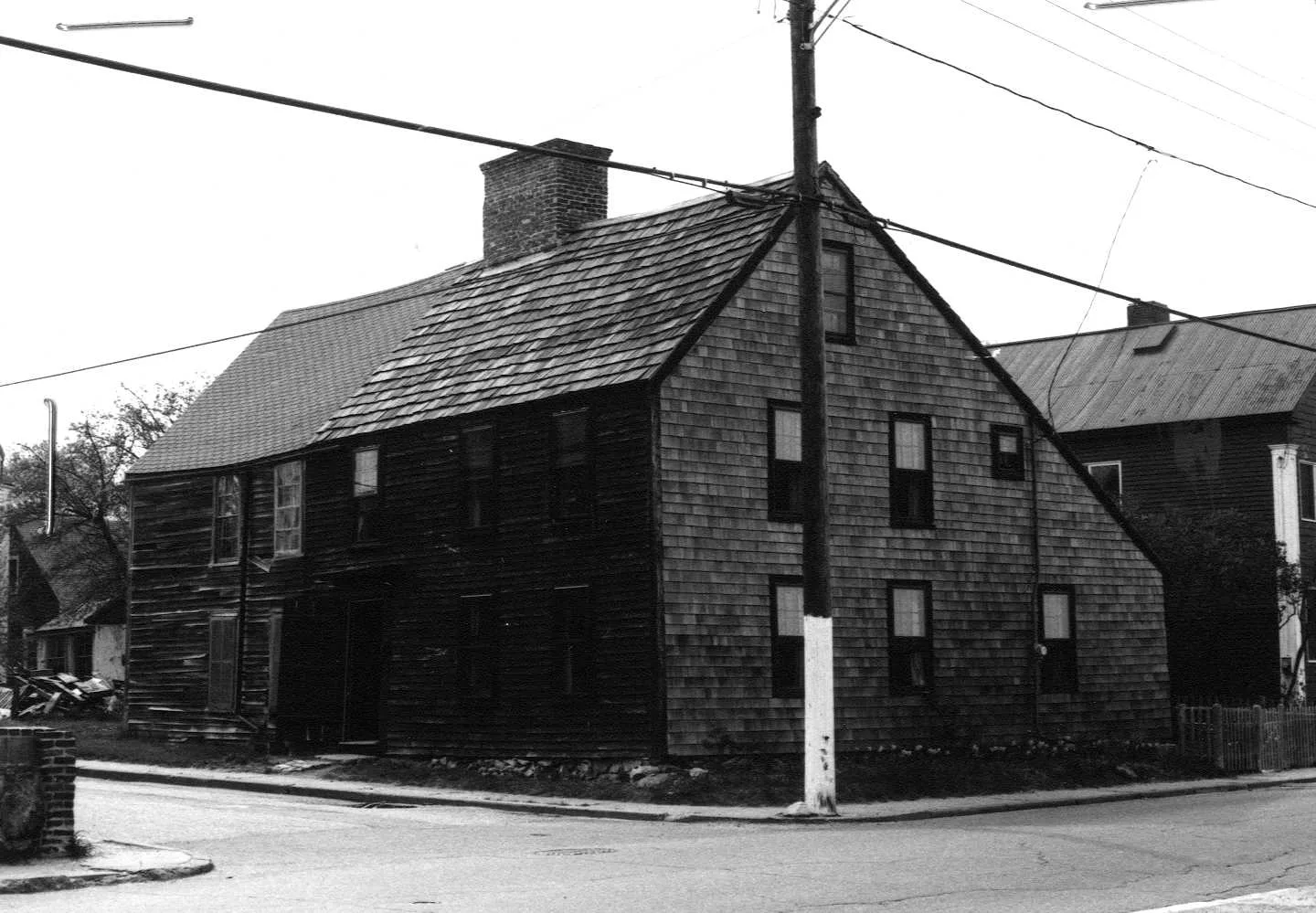
Stop 3 · c. 1700
2 Neptune Street
B. Pettingill–George Thurlow House
Photo: Massachusetts Historical Commission, MACRIS inventory
The state's historic inventory form is all we have on this one, and it is enough to make it the oldest thing on the walk: it calls it the B. Pettingill–George Thurlow House, a First Period house of about 1700, which puts it within sixty-five years of the first settlement of Newbury, and nearly a century before the town line moved. Both names are old South End names. Currier's History of Newbury has Cutting Pettengill and James Thurlow in the Joppa militia company of 1812, and Currier's 1906 History names a Cutting Pettingale of Newbury and a John Thurlo of Newbury among the first trustees of the Methodist meeting house round the corner on Purchase Street in 1827. Neptune Street shares its name with one of the fire engines: Currier's History of Newbury says that when Joppa and Belleville were annexed in 1851 Newbury's two engines came with them, and were renamed Torrent, number seven, and Neptune, number eight, in the city department.
Sources: MACRIS inventory form · Currier, History of Newbury (1902), pp. 288, 628 · Currier, History of Newburyport, vol. 1 (1906), p. 295
Walk · 200 yardsGo back to Water Street and turn right, continuing downstream with the river on your left, for about 185 yards. Stop near the foot of Marlboro Street, which comes in from your right. The ground between Water Street and the river here was the Woodwell yard.
Stop 4 · 1756 · Lost
Woodwell Shipyard
This is the shipyard Mrs. Smith meant when she wrote in 1854 that the south end of town had “one of the primitive ship-yards, long dedicated to the exclusive production of schooners.” Emery says Gideon Woodwell owned a yard “near the foot of Muzzey's lane, now Marlborough street,” in 1759, and Hurd's History of Essex County of 1888 puts it on the lower side of Water Street. Currier gave the yard an appendix of its own in his History of Newbury of 1902. Captain Gideon Woodwell, who had served at Crown Point in 1756, bought a small lot here early in 1762, with a house and barn, between the road and the river, and “built there, previous to the close of the year 1773, a large number of fishing and coasting vessels.” The yard stood idle through the Revolution. From 1783 to 1790 he, his son John and Enoch Hale, as Woodwell & Hale, built ten vessels; the captain died in August 1790, and John Woodwell revived the business about 1800 with his sons John, David and Gideon. “From the year 1800 to 1853, John Woodwell and sons built nearly one hundred vessels, varying in size from fifty to three hundred tons register.”
Smith, writing while the yard was still at work, made the family's total a hundred and fifty-two vessels, fifty-two of them in the captain's first ten years; Currier, in a footnote, thought that figure “probably incorrect.” Our research for this site says about a hundred and sixty small vessels, from the 1750s until 1852. Whichever count you take, this was a schooner yard for ninety years, and when Joppa joined the city a John Woodwell of Ward One sat on the first city council, as Smith and Currier both record.
Sources: Smith, History of Newburyport (1854), pp. 248, 263, 268 · Emery, Reminiscences of a Nonagenarian (1879), p. 225 · Hurd, History of Essex County, vol. 2 (1888) · Currier, History of Newbury (1902), p. 658 · Currier, “Ould Newbury” (1896), ch. "Old Ship-Yards" · Currier, History of Newburyport, vol. 1 (1906), p. 209 · oldnbpt.com research
Walk · 50 yardsCarry on down Water Street about 55 yards. The next opening to the river on your left, with the beach below it, is Goodwin's Landing, the one the neighbourhood still calls Simmons Beach.
Our research for this site calls this the lower slip of Joppa, and says it was renamed Goodwin's Landing in 1945 but is still known as Simmons Beach. The Goodwins were everywhere in the fishing village: Currier's History of Newbury prints the roll of Captain Woodwell's militia company of 1812 with a Captain Daniel Goodwin, an Ensign Josiah Goodwin, a Sergeant Nathaniel Goodwin and Thomas, Saul, Amos and Major Goodwin in the ranks, and it was a William Goodwin who, with John Currier Jr. and others, petitioned in 1851 for the annexation of the other end of Newbury, as Currier's 1906 History and Albert E. Pillsbury's address at the city's fiftieth anniversary both record. Mrs. Smith's 1854 description of the men who used landings like this one is the best there is: “Towards the southerly part of the town, we find the fishermen, many of whom in winter work at shoemaking.” Attached to the houses, she says, were small workshops where “groups of four, six, or eight shoemakers” worked through the winter while they waited for spring and the voyage to the banks and the Labrador. Her chronology dates the Labrador fishery from Newburyport to about 1799 or 1800, and the mackerel fishery to about the same year.
Sources: oldnbpt.com research · Currier, History of Newbury (1902), p. 628 · Currier, History of Newburyport, vol. 1 (1906), p. 207 · Pillsbury, Newburyport and City Government (1901) · Smith, History of Newburyport (1854), pp. 268–269, 396
Walk · 140 yardsWalk on about 20 yards to the foot of Marlboro Street, turn left, and go up Marlboro Street about 55 yards. Turn left into Union Street and follow it about 65 yards back toward the river, to where Union Street and Water Street meet in a sharp wedge. This is Flatiron Point. look: The one surviving clam shack is the low shed by the water; the row it belonged to ran along this bank.
Stop 6
Flatiron Point
Emery remembered the fishing hamlet as “skirting the river and round ‘Flat-iron point,’” and Currier's “Ould Newbury” of 1896 chose this spot for two of its pictures, one labelled Flat-iron Point and the other Clam Houses, both captioned Joppa. By then the trade had changed. Currier says that where cod and mackerel had once been dried on the flakes, “now large quantities of clams are taken daily from the flats in that neighborhood, and made ready for shipment to the far west.” Our research for this site says a row of clam-shucking shacks stood here and that one survives. Emery, looking back to the 1790s, says clams were then a food people turned up their noses at: “Clams in the shell were sold; none were then shucked,” and the peddlers who went about with boiled clams out of the shell were “Algerines” from Seabrook. The “moss-covered houses and quaint little shops on the river bank” that Currier describes stood only a few rods above the start of the Plum Island turnpike, and it was from this corner of town, he says, that the road ran out across the marshes to the island two miles away.
Sources: Emery, Reminiscences of a Nonagenarian (1879), pp. 228, 250 · Currier, “Ould Newbury” (1896), ch. "Plum Island" · oldnbpt.com research
Walk · 250 yardsWalk back up Union Street about 65 yards to Marlboro Street and turn left, away from the river. Go up Marlboro Street about 145 yards, crossing Purchase Street, and turn right onto Purchase Street. The house on the corner, on your right, is the library.
Stop 7 · 1905
Emma L. Andrews Library
This house was William T. Humphrey's before it was a library, and the second volume of Currier's History of Newburyport, published in 1909, tells how it changed. On January 25, 1900, “a few ladies, interested in the education of children and the diffusion of useful knowledge, leased a building on Union street” in Ward One, filled it with books and magazines, hired an attendant and opened it free to the neighbourhood. In February 1904 they formed the South End Reading Room Association, incorporated that March, with Eben C. Knight as president and Emma M. Lander as secretary, and in May 1905 friends of the association bought “the dwelling house No. 75 Purchase street, corner of Marlborough street,” formerly owned and occupied by William T. Humphries, as Currier spells him, remodelled it and dedicated it on the twentieth of July. It had, he says, “several well-furnished and convenient reading rooms and a small library of useful and entertaining books for children,” was open every evening but Sundays and holidays from seven to nine, and depended on gifts, because the city council's annual grant had been ruled illegal. Our research for this site traces the reading room back to 1886, earlier than Currier's date, and says it has been here since 1905; it is now the Emma L. Andrews Library, the South End's branch.
Sources: Currier, History of Newburyport, vol. 2 (1909), pp. 179–180 · oldnbpt.com research
Walk · 210 yardsWalk on along Purchase Street, away from Marlboro Street, for about 200 yards. The church with the tower, on your left, is number 64. look: The tower was added in 1888; the body of the building is the meeting house of 1825, twice enlarged.
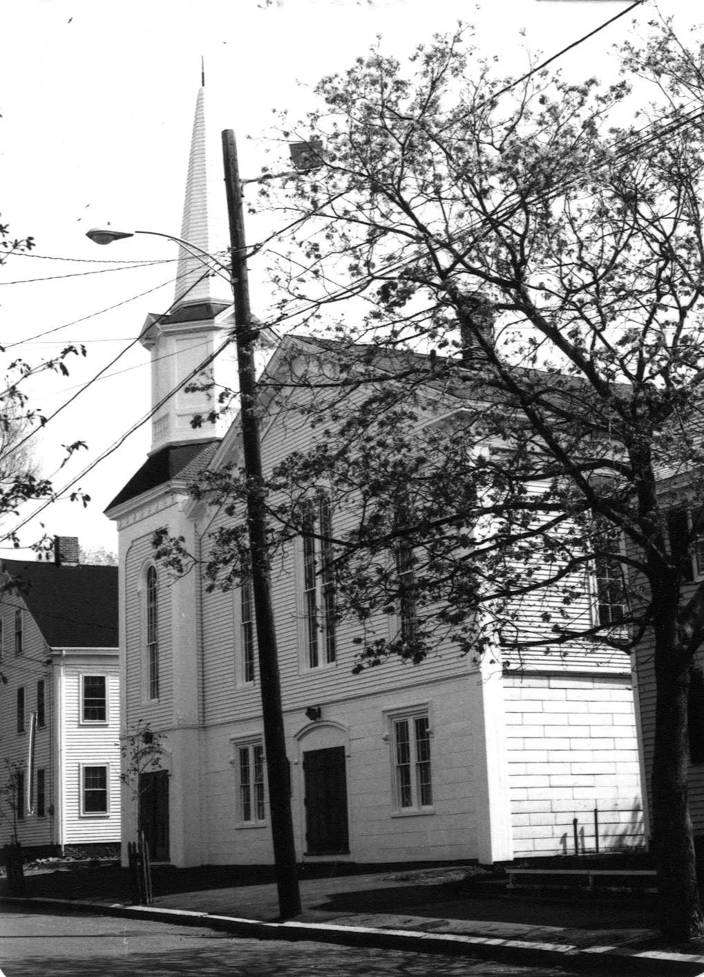
Stop 8 · c. 1825
64 Purchase Street
People's United Methodist Church
Photo: Massachusetts Historical Commission, MACRIS inventory
Currier's History of Newbury of 1902 says the Reverend John Adams, “commonly called ‘Reformation John,’” a Methodist, came to Newbury in 1819, made many converts, and preached week after week in a schoolhouse on Marlborough Street. In 1825 Newbury was made a station of the Salisbury Conference, land was bought, and a meeting house was built “in a field on the northwesterly side of Marlborough street, midway between that street and South street, now Bromfield street,” dedicated on October 5, 1825. It stood in a field because there was no street: Currier's 1906 History says Adelphi Street, now this end of Purchase Street, was laid out by the town of Newbury in 1825 from Bromfield Street “to the first Methodist Episcopal meeting house in Newbury,” and that the Purchase Street name took over the whole length in 1852. On March 5, 1827, John Adams and Benjamin Brown of Newburyport, Cutting Pettingale, John P. Noyes and John Thurlo of Newbury, and Elias French and Caleb Pike of Salisbury were incorporated as trustees, and Emery lists the first pew-holders: Pettingells, Plummers, Hunts, Goodwins, Lunts and Thurlows, the Joppa names. When the meeting house came into the city with the annexation of 1851 it was renamed the People's Methodist Episcopal Church. Currier records the rebuildings: remodelled and enlarged from 1869 and re-dedicated on March 25, 1871; enlarged again in 1888, when the tower was put up for nearly three thousand dollars; painted and frescoed in 1901. The state inventory form dates the building to about 1825 and calls its present style Renaissance Revival, which is the 1871 and 1888 work talking.
Sources: Currier, History of Newbury (1902), pp. 387–388 · Currier, History of Newburyport, vol. 1 (1906), pp. 294–296, 351, 355 · Emery, Reminiscences of a Nonagenarian (1879), p. 321 · Hurd, History of Essex County, vol. 2 (1888) · MACRIS inventory form
Walk · 240 yardsContinue along Purchase Street about 30 yards to where the Clipper City Rail Trail crosses, and turn left onto the trail, away from the river. Follow it about 200 yards, then turn right onto Chestnut Street. The site of the factory is just ahead, at what was 28 Chestnut Street.
Stop 9 · 1879 · Lost
W. H. Noyes and Company Comb Factory
Nothing is left of it, but Currier's 1906 History gives the whole story, and a photograph. Comb-making began in Newbury in 1759, he says, when Enoch Noyes made horn buttons and combs, and took off in 1778 when Noyes hired William Cleland, a deserter from Burgoyne's army and a comb-maker by trade; by 1831 there were twenty comb shops in West Newbury and three in Newburyport. William Noyes Jr. and his son William Herbert Noyes began making combs in Prince Place in 1871. After a partnership as Noyes & Vine ended in 1873 the son worked from a shop on Water Street near the Custom House, then a large building near the foot of Pike Street, until 1879, when, with his brother Davis F. Noyes, as William H. Noyes & Co., “he built a more commodious factory on Chestnut street.” The firm became William H. Noyes & Bro. in 1884 and was incorporated in 1899; in 1904 it bought the stock and machinery of Somerby C. Noyes & Co. of West Newbury and moved them here, and Currier, writing in 1906, says the company was by then the only comb maker left in Newbury, West Newbury or Newburyport. Our research for this site says the factory ran until the 1930s and was torn down soon after.
Sources: Currier, History of Newburyport, vol. 1 (1906), pp. 178–180 · oldnbpt.com research
Walk · 360 yardsWalk along Chestnut Street about 140 yards to Bromfield Street and turn right. Follow Bromfield Street about 200 yards, back toward the river, and turn left onto Purchase Street. Stop a few steps in, where you can look along the blocks between Bromfield, Marlboro and Chestnut Streets. look: The long, narrow lots running between the streets here are the footprints of the walks.
Stop 10 · Lost
The Joppa ropewalks
A ropewalk was a shed a quarter of a mile long, and these streets held several. Emery's list is the fullest. Robert Gardner moved a walk to South Street, which is Bromfield Street, where he and a Mr. Laskey “did a large business at the time of the great fire”; “Messrs. Eleazer Johnson, and Young, and Pettingell had walks extending from South to Marlborough streets”; a Mr. Cummings and a Mr. Akerman ran one from South to Marlborough; “E. & I. Swett built a walk south of Marlborough street”; Deacon Amos Pettingell built one near the Gardner walk, later Pettingell and Donnell's, and Eleazer Johnson another beside it, afterward Wormstead and son's. Mrs. Smith's chronology has a rope-walk in South Street struck by lightning in July 1800. Currier's 1906 History says that after Captain John Crocker's first walk near Frog Pond in 1748 “several others were erected between Cottle's lane, now Bromfield street, and Ordway's lane, now Market street,” and that the cordage factories, with twenty-five to fifty hands apiece, turned out two to three hundred tons a year “of white lines and tarred cordage.” The fish lines went down the hill to the boats; the flakes, Emery says, stood on the uplands just below the walks. Our research for this site says the sheds stood on Bromfield, Marlboro and Chestnut Streets and that the last of them closed in 1894.
Sources: Emery, Reminiscences of a Nonagenarian (1879), pp. 227–228 · Smith, History of Newburyport (1854), p. 396 · Currier, History of Newburyport, vol. 1 (1906), p. 28 · oldnbpt.com research
Back to the start · 580 yardsWalk down Purchase Street, away from Bromfield Street, for about 180 yards and turn left into Harrison Street. Follow Harrison Street about 235 yards down to Water Street and turn right. The park is about 85 yards along on your right, about a third of a mile in all.
On the way down Harrison Street you are walking the route the fish took in the other direction, from the river to the flakes. Currier's History of Newbury says that when the Belleville and Joppa yards were annexed in 1851 “ship-building ceased to be one of the industries of Newbury,” and the Woodwells launched their last schooners two years later. The clams outlasted the cod, and the one shack at Flatiron Point outlasted the row. What is left of Joppa is the shape of it: the landings, the flats, the lots that run from the water up to Purchase Street, and the names on the rolls.
Sources for this walk
The script paraphrases and quotes these works, all of them out of copyright, and names each one as it goes. Page numbers are from the editions linked here. Where the script says “our research for this site,” the facts are from the building page it links to.
- John J. Currier, History of Newburyport, Mass., 1764–1905, vol. 1 (Newburyport: the author, 1906). archive.org/details/historyofnewbury01curr
- John J. Currier, History of Newburyport, Mass., 1764–1905, vol. 2 (Newburyport: the author, 1909). archive.org/details/historyofnewbury04curr
- John J. Currier, “Ould Newbury”: Historical and Biographical Sketches (Boston: Damrell & Upham, 1896). archive.org/details/ouldnewburyhisto00curr
- John J. Currier, History of Newbury, Mass., 1635–1902 (Boston: Damrell & Upham, 1902). archive.org/details/historyofnewbury1902curr
- E. Vale Smith, History of Newburyport; from the Earliest Settlement of the Country to the Present Time (Newburyport, 1854). archive.org/details/historyofnewbury00blake
- Sarah Anna Emery, Reminiscences of a Nonagenarian (Newburyport: William H. Huse, 1879). archive.org/details/reminiscencesofn00emer
- D. Hamilton Hurd, comp., History of Essex County, Massachusetts, vol. 2 (Philadelphia: J. W. Lewis & Co., 1888). archive.org/details/historyofessexco02hurd
- Albert E. Pillsbury, Newburyport and City Government: An Address Delivered at the Celebration of the Fiftieth Anniversary of the City (Newburyport, 1901). archive.org/details/newburyportcityg00pill
- Massachusetts Historical Commission, Massachusetts Cultural Resource Information System (MACRIS), Newburyport inventory forms. mhc-macris.net
- Biff Bouse, oldnbpt.com building pages (own research from deeds, Sanborn maps and newspapers). oldnbpt.com
More walks: State Street and Market Square · Green Street, Brown Square and Pleasant Street · High Street: Down Along and the Ridge · Federal, Spring and Middle Streets · The Water Street Waterfront · Joppa: The Oldest Houses · Along the River: The North End Shipyards · The Rail Trail: Mills, Ropewalks and Old Hill · Newburyport in the Civil War · Churchyards and Burying Grounds