Walking tours · Rail trail · 12 stops
The Rail Trail: Mills, Ropewalks and Old Hill
A loop of about a mile and three quarters that starts where the old Eastern Railroad came off its bridge, follows Merrimac Street past the sites of a steam cotton mill, an iron foundry and the Caldwell rum distillery, climbs Strong Street to the house of Lord Dexter's wood-carver, and then takes the rail trail itself, past the ground where John Tracy spun rope and the Quakers buried their dead, under High Street to the edge of the Old Hill Burying Ground.
- Length
- About 1.8 mi, a loop
- Time
- About 65 min, with the reading
- Start and finish
- The rail trail at Merrimac Street, by the river
Before you set off
The railroad made this corner of town. John J. Currier's History of Newburyport, published in 1906, says that in February 1836 the inhabitants voted to approve a petition for a railroad through the town, to run “across the Pond to Greenleaf's field,” over Union, Titcomb, Market and Summer Streets and “thence across Merrimack street over the Newburyport Bridge,” and instructed their representatives to see, if possible, that the cars ran through the streets at a speed “not exceeding four miles per hour.” After long debate the charter of the Eastern Railroad was amended to carry the line “west of the jail and under High street by a suitable tunnel,” and trains were running from Boston by June 1840. The walk follows that line, from the river to the tunnel under High Street, and the streets beside it.
Before the railroad, this was the industrial end of Merrimac Street. Caleb Cushing's History and Present State of the Town of Newburyport, published in 1826, says the town had local advantages for two manufactures, “the distillation of rum, and ship-building,” which the citizens themselves had put at the head of their business in a memorial to Congress in 1774. Currier counts ten distilleries in the town in 1790 and four by the census of 1820, all of them on Merrimac Street, at the foot of Warren Street, the foot of Kent Street, the corner of Williams Court and the corner of Strong Street, and he names John Tracy's ropewalk near the Quaker burying ground, there before Washington Street was laid out. Sarah Anna Emery, who was born in 1787 and wrote her Reminiscences of a Nonagenarian at ninety, remembered the distilleries, the bakeries and the ropewalks of this neighborhood by name. The steam mills and the foundry came after the railroad, and the rail trail came after them all.
Numbers follow the walk. The line is the route along the streets, back to where you started.
Read it aloud as you go: each stop begins with where to walk and where to stand, then what the old histories say about the place. The sources are named as you read and listed in full at the end.
StartThe loop begins at the Merrimac Street end of the Clipper City Rail Trail, by the river, where Boardman Street meets Merrimac Street a short way downstream of the Route 1 bridge. There is parking along Merrimac Street and in the lots by the trailhead. Stand at the head of the trail with your back to the river and the trail running away from you, up through the city.
Stop 1 · 1827
Newburyport–Salisbury railroad bridge
The railroad bridge that the trail now uses had a life before the trains. Currier's History of 1906 says the Newburyport Bridge to Salisbury, a suspension bridge built under the direction of Thomas Haven of Portsmouth, was far enough along in October 1827 that the stage coaches could cross its upper section, and both driveways were open six weeks later. In March 1840 the Eastern Railroad Company bought all the iron, timber and plank of the old bridge for five thousand dollars and paid the proprietors eight thousand more for the right to build on its four stone piers and two abutments “a new bridge with two road-beds, one above the other,” carts, carriages and foot passengers below and the railroad above. On October 28, 1840, Currier says, the first train of cars crossed from Newburyport to Salisbury, and twelve days later the road was open to Portsmouth. The strain of the trains told: in 1865 a more substantial railroad bridge went up a short distance above the old one, the old bridge was laid out as a public highway in 1868, and the whole crossing was rebuilt in 1903 at a cost of three hundred and twenty-five thousand dollars. Our research for this site calls this the second bridge across the Merrimack at Newburyport, after the Chain Bridge upstream. The first passenger station, Currier adds, was a one-storey wooden building on Washington Street with big swinging doors, left open for trains to pass, and a bell rung on their arrival and departure.
Sources: Currier, History of Newburyport, vol. 1 (1906), pp. 373–376, 399–400 · oldnbpt.com research
Walk · 90 yardsWalk the thirty-odd yards up Boardman Street to Merrimac Street and turn left, upstream, with the river on your right. After about sixty yards the condominiums on the river side, River's Edge, stand on the old wharf.
Stop 2 · Lost
Pearson’s Wharf
The histories have nothing on this wharf under its later name, so what we know comes from our own research for this site: this was the last home of Pearson's Bakery, and from 1934 the home of a new Caldwell distilling company, which moved here from the foot of Kent Street, where this walk is going next. The Pearsons were bakers in Newburyport long before that. Emery, listing the shops of her girlhood in the 1790s, says that “Messrs. Theodore and John Pearson's bakeries were on Centre street,” and that Ebenezer Pearson had another on Middle Street; whether the firm that ended up on this wharf descends from them the histories do not say. The river's edge here, between the two bridges, is the water the railroad crossed and the distillers and bakers shipped from.
Sources: oldnbpt.com research · Emery, Reminiscences of a Nonagenarian (1879), p. 228
Walk · 160 yardsTurn round and walk back down Merrimac Street, downstream, with the river now on your left, for about a hundred and sixty yards, past the trailhead and under the Route 1 bridge, to the foot of Strong Street. The wharf on the river side here held the cotton mill.
Stop 3 · 1836 · Lost
Newburyport Steam Cotton Mill
Newburyport tried steam-driven cotton before it tried anything else with steam. The second volume of Currier's History, published in 1909, says a factory for making cotton cloth was put up in 1835 near the foot of Strong Street, “on the wharf next above the Newburyport bridge,” a building a hundred and thirteen feet long, forty feet wide and three storeys high, with a forty-horsepower engine to drive three thousand spindles. It was ready to run in the spring of 1836, and on March 11 of that year Enoch S. Williams, Samuel T. DeFord and Richard Stone were incorporated as the Newburyport Steam Cotton Company, with Stephen W. Marston as president. The company was dissolved and the property sold in 1843; the Essex Steam Mills, incorporated in February 1844 by James Read, George Gardner and Edmund L. Le Breton, bought the factory and made cotton cloth here until March 6, 1856, when the building burned. Mrs. E. Vale Smith's History of Newburyport of 1854, written while the mill was still running, lists the Essex Steam Mill among the town's corporations with George Gardner as president. The bigger mills that followed, the Bartlet, James and Globe mills, were built elsewhere in town, and nothing of this one is left on the wharf.
Sources: Currier, History of Newburyport, vol. 2 (1909), pp. 148–149 · Smith, History of Newburyport (1854), p. 285 · oldnbpt.com research
Walk · a few stepsWalk on a few steps, about fifteen yards, along Merrimac Street. The foundry stood here at 129 Merrimac Street, on the corner of what was Williams Court.
Stop 4 · 1860 · Lost
Albert Russell and Sons Foundry
Currier's History of 1906 traces the iron founders of the town to this corner. Robert Russell and Eleazer R. Walker set up an iron foundry in 1840 on Brown's wharf at the foot of Green Street, and by 1854 Albert Russell had charge of it. In 1857 the firm of Holmes & Nichols leased a brick building on the corner of Merrimac Street and Williams Court and turned it into an iron foundry and machine shop, and in 1860 Albert Russell bought their stock and goodwill and moved his foundry from Brown's wharf to the westerly end of this building. In 1872 more space was added and his sons Edward P. and Albert Jr. joined him as Albert Russell & Sons; in 1906 the works were still running under William F. Runnells. The second volume of Currier's History says the city's steam fire engine No. One was rebuilt here by the Albert Russell and Sons Company in 1902. Our research for this site says the foundry cast fences, ship fittings and Grand Army grave markers into the early 1900s, and Mrs. Smith, walking up Merrimac Street in 1854, passed “on Brown's wharf, the iron foundry,” Mr. Lesley's machine shop and a marble yard before she reached the railroad bridge.
Sources: Currier, History of Newburyport, vol. 1 (1906), p. 182 · Currier, History of Newburyport, vol. 2 (1909), p. 41 · Smith, History of Newburyport (1854), p. 270 · oldnbpt.com research
Walk · 310 yardsTurn round again and walk back up Merrimac Street, upstream, with the river on your right, for about three hundred yards, past the trailhead and Boardman Street, to the foot of Kent Street, which comes down from your left. The distillery stood on the river side here.
Stop 5 · 1772 · Lost
Caldwell’s Distillery
This was the last rum distillery in Newburyport and for a long time the best known. Currier's History of 1906 says that of the four distilleries counted in 1820, one was at the foot of Kent Street, and that in his own day “the distillery at the foot of Kent street, owned by Messrs. Alexander and George J. Caldwell, is the only one in operation within the limits of Newburyport.” Emery, remembering the trade of her girlhood, says that “Caldwell's on Merrimac street was even then noted, for its rum, anise and other cordials.” Mrs. Smith, walking this way in 1854, found “a little beyond the railroad bridge, the distillery of Mr. Caldwell.” Our research for this site puts the founding at 1772 by Alexander Caldwell, who is buried in the Old Hill Burying Ground at the end of this walk, and says the family business closed with Prohibition in 1918, a new company opening on Pearson's Wharf in 1934.
Hurd's History of Essex County, published in 1888, gives the distillery its fullest notice. The old works had come down in the family and been run by them for a hundred years, he says, keeping the reputation of producing “the best liquor of its kind in the United States,” which he credits chiefly to the water: the south bank of the Merrimack is full of springs, and the well that fed the still was one of them, so inexhaustible that a steam fire engine made little impression on it. The works covered an acre, with a bonded warehouse, and in 1873 paid the federal government more than three hundred thousand dollars in tax, “more than a thousand dollars a day for every working day of that year.” The firm of Alexander & George J. Caldwell, Hurd says, stood first on the list of taxpayers in the city, and Alexander Caldwell had put his money into ships, cotton, paper, carpets, hats and silver as well as rum.
Sources: Currier, History of Newburyport, vol. 1 (1906), pp. 145–147 · Emery, Reminiscences of a Nonagenarian (1879), p. 228 · Smith, History of Newburyport (1854), p. 270 · Hurd, History of Essex County, vol. 2 (1888) · oldnbpt.com research
Walk · 440 yardsTurn back downstream once more and walk about three hundred and fifty yards along Merrimac Street, past Boardman Street and the trailhead, to Strong Street, and turn right, up the hill away from the river. About ninety yards up, the two-storey hip-roofed house with the five-window front is number 9. look: The hipped roof, which the inventory form says is uncommon on Newburyport's Georgian houses, and the Greek Revival doorway with sidelights that was put on later.
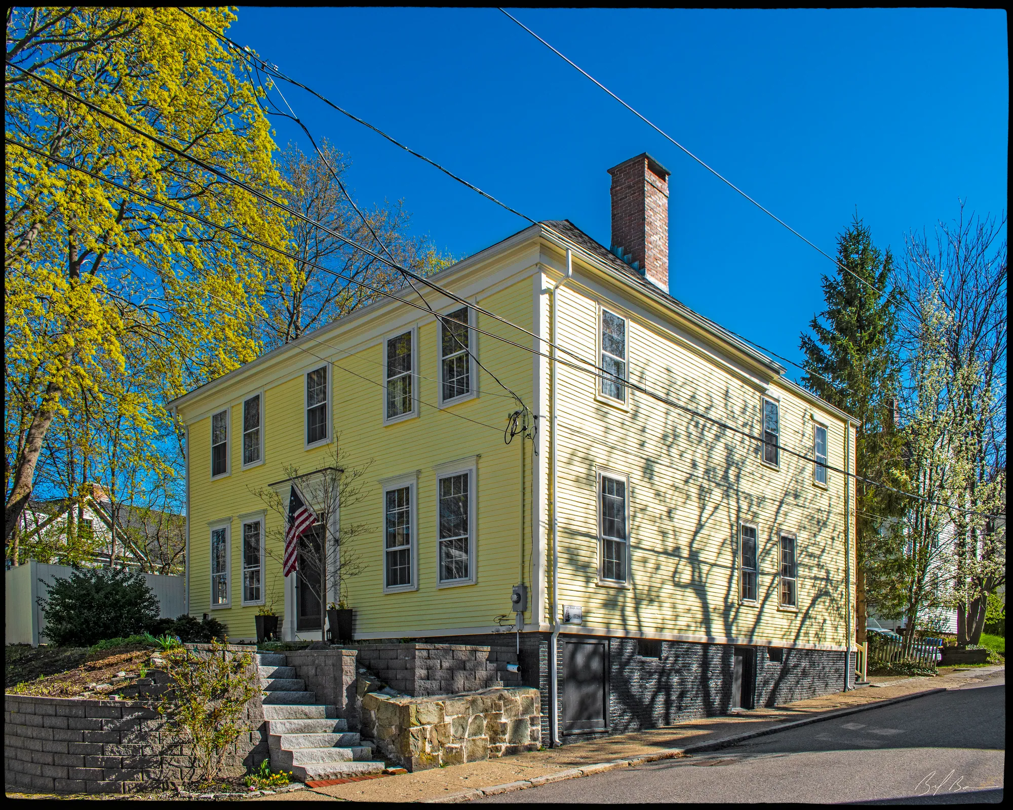
This is the oldest house on the walk, and it was built before Strong Street existed. The second volume of Currier's History says that after his first wife died, Captain Joseph Atkins bought about an acre and a half of land “at the foot of what is now Strong street,” running from the river to the land of Hathorn Coker, part of the homestead of Richard Bartlet, “and on this land he built a spacious dwelling house.” On April 7, 1730, he married Mary, widow of Francis Wainwright of Boston and daughter of Joseph Dudley, governor of the province. Emery says the house “is still standing on the lower side of Strong street,” and that when it was built it stood in grounds reaching to High Street: “a garden handsomely laid out stretched in front to the river, and a broad avenue shaded by trees led to the mansion.” Currier gives the rest of him: born at Sandwich in England, a sea commander, granted liberty in 1738, with sixty-four others according to Joshua Coffin's Sketch of the History of Newbury of 1845, to build a wharf at the foot of Market Street, and the giver, in 1741, of the land under St. Paul's Church, where he was buried after his death on January 21, 1773, in his ninety-third year. Currier's 1906 History says the street itself was accepted in March 1819 and named Strong Street, a century after the house.
The state inventory form carries it on: James M. Cooper, a house carpenter, owned it from before 1851, and his heirs kept it until 1919. The form calls the house Georgian with Greek Revival alterations, but dates it to about 1790 to 1803 while also crediting Atkins with building it about 1730; the histories are on the side of the earlier date.
Sources: Currier, History of Newburyport, vol. 2 (1909), pp. 198–200 · Emery, Reminiscences of a Nonagenarian (1879) · Coffin, Sketch of the History of Newbury (1845), p. 404 · Currier, History of Newburyport, vol. 1 (1906), p. 359 · MACRIS inventory form
Walk · 180 yardsBefore you leave number 9, look across Strong Street at number 12, the house opposite, and at its doorway. Then walk back down Strong Street toward the river about sixty yards and turn right onto the short path that leads to the rail trail; turn right onto the trail, heading away from the river, and after about ninety yards you are behind the same house, which sits between the trail and Strong Street on your right. look: The carved doorway on the Strong Street front is said by our research for this site to be the carver's own work.
Our research for this site makes this the home of Joseph Wilson, ship carver, who lived from 1779 to 1857 and carved the statues for Timothy Dexter. The histories put him on this street at the right moment. The second volume of Currier's History says that early in 1801 Dexter had wooden statues of Washington, Jefferson and Adams set on an arch over his front door on High Street, and then filled his grounds with pedestals fifteen feet high carrying statues of philosophers, statesmen and politicians, one of them of himself, inscribed “I am the first in the East, the first in the West, and the greatest philosopher in the known world.” All of them, Currier says, with four lions, a unicorn and other objects, “came from the workshop of Joseph Wilson, a young ship-carver, then living on Strong street, Newburyport.” Currier's “Ould Newbury” of 1896 adds that they were gaudily painted and had little merit as art and less as likenesses, but drew crowds. William C. Todd's sketch of Dexter, published in 1886, says Knapp had the images costing fifteen thousand dollars, but that an old gentleman who remembered Dexter and knew the artist told him “the price was $100 for each, and that Dexter made as sharp a bargain as he could with the artist, as he did with everyone.” Emery, who calls the carver James Wilson, thought better of the work than Currier did: “In this work Mr. Wilson displayed the power of a sculptor; it is a pity he never aspired to works of greater durability.”
Sources: oldnbpt.com research · Currier, History of Newburyport, vol. 2 (1909), p. 423 · Currier, “Ould Newbury” (1896), ch. "Dexter House" · Todd, Timothy Dexter (1886) · Emery, Reminiscences of a Nonagenarian (1879), p. 251
Walk · 200 yardsFollow the rail trail on, away from the river, for about a hundred and thirty yards to Washington Street. Cross with care, turn right along Washington Street for about thirty yards, and turn right again into the upper end of Strong Street; stop about thirty-five yards in. The ropewalk ran across this ground.
Stop 8 · 1764 · Lost
John Tracy’s Ropewalk
Rope was spun in long sheds, and this corner was one of them. Currier's History of 1906, describing the trade of the town in its early years, says cordage factories employing twenty-five to fifty hands made two to three hundred tons of white lines and tarred cordage a year, and that “John Tracy was a manufacturer of cordage near the Quaker burying ground, before Washington street was laid out between Winter and Boardman streets”; his bill-heads, Currier says, were engraved on copper, and he reproduces one. Emery is more exact about the lie of it: “In 1785, before Washington street was laid out, Mr. John Tracy had a rope-walk running from the Quaker burying ground to the river.” She thought a later walk of Mr. Green Pearson, from Washington to Water Street, was the same one. Mrs. Smith's History of 1854 agrees, and says this land, with its neighborhood, “was formerly called Quaker field.” Our research for this site dates the walk to 1764 and calls it one of the town's two early ropewalks.
John Tracy was no mere ropemaker. “Ould Newbury” says he was the son of the merchant Patrick Tracy, born in 1753, lived in the Lowell house on High Street next to the Dexter House, which his father bought for him, and served in Rhode Island as aide-de-camp to General Glover; with his brother Nathaniel he sent out privateers, and Emery says the Tracys' ships took a hundred and twenty prizes. Currier's 1906 History says Washington Street, from Winter Street to Boardman Street, was accepted in May 1800, which is when the ropewalk's ground became a street.
Sources: Currier, History of Newburyport, vol. 1 (1906), pp. 27, 357–358 · Emery, Reminiscences of a Nonagenarian (1879), pp. 176, 227–228 · Smith, History of Newburyport (1854), p. 47 · Currier, “Ould Newbury” (1896), ch. "Patrick Tracy" · oldnbpt.com research
Walk · 60 yardsWalk back down Strong Street the thirty yards to Washington Street and turn right. About twenty yards along, the ground on the far side of Washington Street, opposite the head of Strong Street, was the burying ground. There is nothing to cross for; look from this side.
Stop 9 · 1744 · Lost
Quaker Burying Ground
This was a family burying ground that the town called the Quakers'. Emery says Samuel Coker, son of Hathorne Coker, owned a large tract at the north end of the town and joined the Society of Friends, as did his son Thomas, who built several houses here, and that “The family burial place was in a lot on Washington, nearly opposite the head of Strong street.” Currier's History of Newbury, published in 1902, traces the lot to a bequest of 1695 by Richard Bartlett to his daughter Tirzah, who married Hathorn Coker, and to an agreement of 1768 among the Coker heirs, when they divided the Coker field, that nine square rods at its northwest corner should be kept “for a Burying Place for them and their heirs forever.” The entrance, Currier says, was from the southwesterly side of Washington Street, and a low granite monument put up in June 1865 read, in capitals, the family cemetery of Hathorn Coker, who with many of his descendants lie buried here. Mrs. Smith, in 1854, says some of the Quakers “were buried in a lot of land in the rear of the westerly side of Washington street, between the railroad crossing and Boardman street.”
The Friends' own meeting house was not here but on High Street. Currier's History of Newbury says it was built in 1743 on land Stephen Sawyer gave that June to Robert Rogers, Daniel Sawyer, Samuel Coker, Hathorn Coker Jr. and others, between what are now Woodland and Ashland Streets, a plain building about thirty by forty feet and two storeys high; Mrs. Smith dates it 1744. In 1825 the society sold the lot to Josiah Little and built anew near Turkey Hill. Our research for this site says the old building was moved and survives at 36 Ferry Road, and that the stones here could still be seen in the early 1900s.
Sources: Emery, Reminiscences of a Nonagenarian (1879), p. 86 · Currier, History of Newbury (1902), pp. 389–392 · Smith, History of Newburyport (1854), p. 47 · oldnbpt.com research
Walk · 110 yardsCarry on along Washington Street, away from Strong Street, for about a hundred and ten yards, to where the Route 1 bypass crosses it. Stop short of the junction, on the pavement.
Stop 10 · 1934
Route One bypass
The road roaring across in front of you is the newest thing on the walk, and the only one the old histories cannot describe. Our research for this site says the Washington Street bypass for Route 1 was begun in 1930 and finished in 1934, and that houses were moved or torn down to make way for it on Winter, Summer, High, Vernon and Railroad Streets. The street you are standing on is older than the one it crosses by more than a century: Currier's History of 1906 says the stretch of Washington Street from Winter Street to Boardman Street was accepted in May 1800, that Adams Street carried it on toward Olive Street in 1823, and that in 1852 the whole run from Green Street to Olive Street was given the one name. The railroad crossed Washington Street just behind you, where the trail does now; Mrs. Smith in 1854 used “the railroad crossing” as a landmark for the Quaker lot. Within a century of the first train the highway builders cut through the same neighborhood again.
Sources: oldnbpt.com research · Currier, History of Newburyport, vol. 1 (1906), pp. 357–358 · Smith, History of Newburyport (1854), p. 47
Walk · 290 yardsContinue along Washington Street about seventy yards and carry straight on into Winter Street, which climbs away from the river for about a hundred and forty yards to High Street. Turn right onto High Street and walk about eighty yards. The three-storey house on your right, behind its cast-iron fence, is number 182. look: The medallion cornice and the small square third-floor windows are Federal; the two-storey projecting central bay and the iron fence, the inventory form says, were added in the mid-1800s.
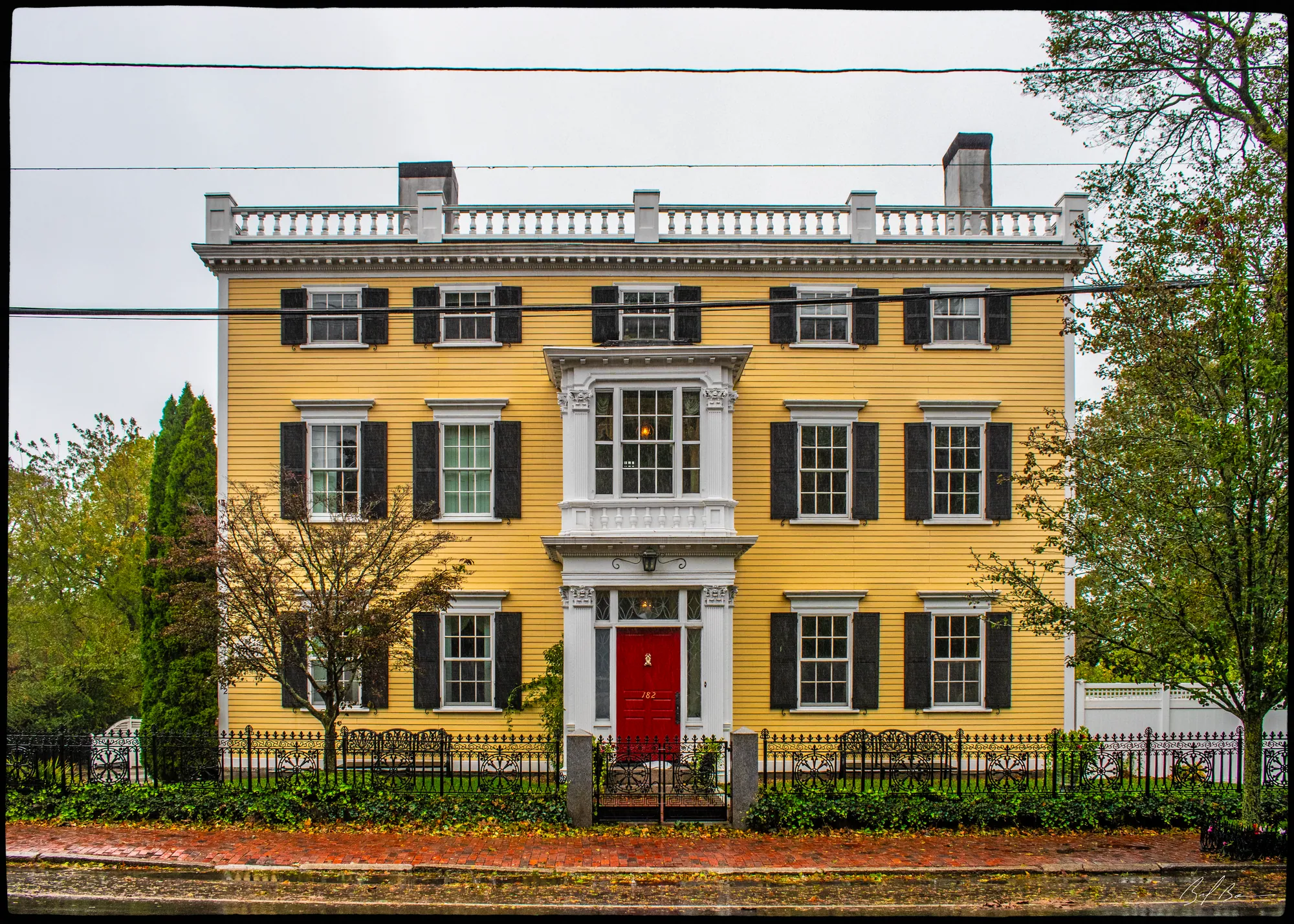
Albert Hale's Old Newburyport Houses, a 1912 collection of photographs, says the land was bought in 1792 by Abner Wood, who then built this house, “similar in appearance to the Pike-Coffin House,” and that in 1819 it was bought from Wood by Ebenezer Moseley; in Hale's day it was the home of Moseley's descendant Charlotte, Mrs. Arthur C. Nason, and he photographed the hallway. The state inventory form adds Wood's losses: three of his vessels, the brig Sally Ann, the schooner Speedwell and the brig Minerva, were taken by the French, and he claimed compensation from the government. The appendix to the second volume of Currier's History has him on the board of selectmen from 1801.
Moseley is the name the house keeps. The second volume of Currier's History says he was born in Windham, Connecticut, in 1781, graduated from Yale in 1802, came to Newburyport in 1805 and opened a law office that soon had a large practice; he was colonel of the sixth regiment of militia from 1813, a vigorous opponent of the embargo and the War of 1812, representative to the General Court from 1815 to 1819 and senator in 1821 and 1822, and he “made the address of welcome to General LaFayette when he visited Newburyport in August, 1824.” Currier's 1906 volume says that address was delivered in the Tracy house on State Street, because heavy rain had wrecked the procession; Moseley had done the same office for President Monroe in 1817. He was a presidential elector for Henry Clay in 1832, presided at the two-hundredth anniversary of Newbury in 1835, and was Daniel Webster's associate in the Goodridge robbery trial of 1816. He died on August 28, 1854. The inventory form carries the house to his son Edward S. Moseley, president of the Mechanics' Bank, and then to Mrs. Nason.
Sources: Hale, Old Newburyport Houses (1912), p. 12 · MACRIS inventory form · Currier, History of Newburyport, vol. 2 (1909), pp. 272–274 · Currier, History of Newburyport, vol. 1 (1906), pp. 415–416
Walk · 400 yardsWalk on along High Street, away from Winter Street, for about eighty yards to where the rail trail crosses. Cross High Street there; the way down onto the trail is on the far side, a few steps back toward Winter Street. Turn right onto the trail, heading away from the river, and follow it about three hundred yards through the cut. The Old Hill Burying Ground is on the slope above you to your left; stop where you can see its stones through the trees.
Stop 12 · 1729
Old Hill Burying Ground
You are in the railroad's own cut here. Currier's History of 1906 says the Eastern Railroad's charter was amended in 1836 to carry the line “west of the jail and under High street by a suitable tunnel,” the jail then standing near Frog Pond, and that is the route the trail follows. The burying ground above you is older than anything else on the walk. Currier's “Ould Newbury” of 1896 says the Third Parish of Newbury chose a committee in November 1729 to find a burying place, and in March 1730 the assessors were told to fence “the lot of land in the rear of Frog Pond, then known as Snelling's hill,” after Dr. William Snelling, a physician in Newbury in 1650. Currier's 1906 History says the ground was enlarged in 1790 to Pond Street on the west and Auburn Street on the north, and that a brick powder house built beside it in 1754 gave the hill its other name.
“Ould Newbury” walks the stones: the Reverend John Lowell, first minister of the parish; Daniel Farnham the loyalist; Nathaniel Tracy, John Tracy's brother; and Timothy Dexter, “The Lord of the East, Lord of the West, and the greatest philosopher in the known world,” who died October 26, 1806, which brings this walk back to the carver on Strong Street. The 1906 History adds the French refugees from Guadeloupe and Santo Domingo buried on the northwesterly side, and the seven seamen of the brig Pocahontas, wrecked on Plum Island in December 1839. Our research for this site adds Alexander Caldwell, the distiller from the foot of Kent Street, and Fortune, enslaved in the Dalton household on State Street, whose stone the Daltons set up. Currier's warning of 1896, that many stones “show signs of age, and need to be carefully repaired and relettered,” still holds. The gate is on Greenleaf Street, on the far side of the hill, for another day.
Sources: Currier, History of Newburyport, vol. 1 (1906), pp. 212–215, 399–400 · Currier, “Ould Newbury” (1896), ch. "Old Hill Burying Ground" · oldnbpt.com research
Back to the start · 910 yardsTurn round and follow the rail trail back the way you came, toward the river, for about seven hundred yards: under High Street, across Washington Street at the crossing, past the back of the Wilson house, to the trail's end at Strong Street. Turn right down Strong Street for forty yards to Merrimac Street, turn left along Merrimac Street for about a hundred and twenty yards, and turn left into Boardman Street; the trailhead where you started is just ahead, about half a mile in all.
The trail you are walking back on is the line the town argued over in 1836 and rode for a century and more. Currier says the first trains left Boston for Newburyport at seven in the morning, noon and half past three, and came back at half past seven, ten and four. The mills, the foundry and the distillery that grew up along the line are gone, and the railroad has become the quietest way through the North End.
Sources for this walk
The script paraphrases and quotes these works, all of them out of copyright, and names each one as it goes. Page numbers are from the editions linked here. Where the script says “our research for this site,” the facts are from the building page it links to.
- John J. Currier, History of Newburyport, Mass., 1764–1905, vol. 1 (Newburyport: the author, 1906). archive.org/details/historyofnewbury01curr
- John J. Currier, History of Newburyport, Mass., 1764–1905, vol. 2 (Newburyport: the author, 1909). archive.org/details/historyofnewbury04curr
- John J. Currier, “Ould Newbury”: Historical and Biographical Sketches (Boston: Damrell & Upham, 1896). archive.org/details/ouldnewburyhisto00curr
- John J. Currier, History of Newbury, Mass., 1635–1902 (Boston: Damrell & Upham, 1902). archive.org/details/historyofnewbury1902curr
- Joshua Coffin, A Sketch of the History of Newbury, Newburyport, and West Newbury, from 1635 to 1845 (Boston: Samuel G. Drake, 1845). archive.org/details/sketchofhistoryo00coff_0
- E. Vale Smith, History of Newburyport; from the Earliest Settlement of the Country to the Present Time (Newburyport, 1854). archive.org/details/historyofnewbury00blake
- Sarah Anna Emery, Reminiscences of a Nonagenarian (Newburyport: William H. Huse, 1879). archive.org/details/reminiscencesofn00emer
- Albert Hale, comp., Old Newburyport Houses (Boston: W. B. Clarke Co., 1912). archive.org/details/cu31924015356714
- William C. Todd, Timothy Dexter, Known as “Lord Timothy Dexter,” of Newburyport, Mass.: An Inquiry into His Life and True Character (Boston, 1886). archive.org/details/timothydexterkno00todd
- D. Hamilton Hurd, comp., History of Essex County, Massachusetts, vol. 2 (Philadelphia: J. W. Lewis & Co., 1888). archive.org/details/historyofessexco02hurd
- Massachusetts Historical Commission, Massachusetts Cultural Resource Information System (MACRIS), Newburyport inventory forms. mhc-macris.net
- Biff Bouse, oldnbpt.com building pages (own research from deeds, Sanborn maps and newspapers). oldnbpt.com
More walks: State Street and Market Square · Green Street, Brown Square and Pleasant Street · High Street: Down Along and the Ridge · Federal, Spring and Middle Streets · The Water Street Waterfront · Joppa: The Oldest Houses · Joppa: The Fishing Village · Along the River: The North End Shipyards · Newburyport in the Civil War · Churchyards and Burying Grounds